Beech Grove, McLean County, Kentucky

Last updated

Beech Grove, Kentucky
Beech Grove, McLean County, Kentucky.jpg
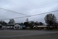
Intersection of KY 56 and KY 136 in Beech Grove
USA Kentucky location map.svg
Red pog.svg
Beech Grove
Usa edcp location map.svg
Red pog.svg
Beech Grove
Coordinates: 37°36′58″N87°23′47″W / 37.61611°N 87.39639°W / 37.61611; -87.39639
Country United States
State Kentucky
County McLean
Area
[1]
  Total1.86 sq mi (4.81 km2)
  Land1.84 sq mi (4.78 km2)
  Water0.01 sq mi (0.03 km2)
Elevation
410 ft (120 m)
Population
 (2020) [2]
  Total282
  Density152.85/sq mi (59.02/km2)
Time zone UTC-6 (Central (CST))
  Summer (DST) UTC-5 (CDT)
ZIP code
42322
Area codes 270 & 364
FIPS code 21-04978
GNIS feature ID486710 [3]

Beech Grove is an unincorporated community and census-designated place in McLean County, Kentucky, United States. Its population was 282 as of the 2020 census. [2] Beech Grove has a post office with ZIP code 42322, which opened on April 29, 1878. [4] [5]

Contents

Geography

Beech Grove is in northwestern McLean County.

According to the U.S. Census Bureau, the Beech Grove CDP has an area of 1.858 square miles (4.81 km2); 1.845 square miles (4.78 km2) of its area is land, and 0.013 square miles (0.034 km2) is water. [1]

Transportation

Kentucky Routes 56, 136, and 256 pass through the community. [6] KY 136 leads southeast 10 miles (16 km) to Calhoun, the county seat, and west 8 miles (13 km) to Sebree. KY 56 leads west to Sebree with KY 136 but turns northeast in Beech Grove to lead 22 miles (35 km) to Owensboro. KY 256 leads southeast to Calhoun by a more southerly route.

Notable Citizens

None

Demographics


Historical population
CensusPop.Note
2010 243
2020 28216.0%
U.S. Decennial Census [7]

Related Research Articles

<span class="mw-page-title-main">McLean County, Kentucky</span> County in Kentucky, United States

McLean County is a county located in the U.S. state of Kentucky. As of the 2020 census, the population was 9,152. Its county seat is Calhoun and its largest city is Livermore. McLean is a prohibition or dry county. McLean County is part of the Owensboro, KY Metropolitan Statistical Area, which has a population of some 114,752.

<span class="mw-page-title-main">Clifton, Colorado</span> Census-designated place in Mesa County, Colorado, United States

Clifton is a census-designated place (CDP) and post office in and governed by Mesa County, Colorado, United States. It is part of the Grand Junction, CO Metropolitan Statistical Area. The Clifton post office has the ZIP Code 81520. As of the 2020 census, the population of the Clifton CDP was 20,413.

<span class="mw-page-title-main">Calhoun, Kentucky</span> City in Kentucky, United States

Calhoun is a home rule-class city in McLean County, Kentucky, United States. The population was 725 at the 2020 census. It is the county seat of McLean County. It is included in the Owensboro, Kentucky Metropolitan Statistical Area.

<span class="mw-page-title-main">Sacramento, Kentucky</span> City in Kentucky, United States

Sacramento is a home rule-class city in McLean County, Kentucky, in the United States. The population was 429 as of the 2020 census. It is included in the Owensboro metropolitan area.

<span class="mw-page-title-main">Attica, Michigan</span> Census-designated place & unincorporated community in Michigan, United States

Attica is an unincorporated community and census-designated place in Attica Township, Lapeer County, Michigan, United States. Its population was 994 as of the 2010 census. Attica has a post office with ZIP code 48412.

<span class="mw-page-title-main">Orchard, Colorado</span> Unincorporated community in Colorado, United States

Orchard is an unincorporated town, a post office, and a census-designated place (CDP) located in and governed by Morgan County, Colorado, United States. The CDP is a part of the Fort Morgan, CO Micropolitan Statistical Area. The Orchard post office has the ZIP Code 80649. As of the 2020 census, the population of the Orchard CDP was 76.

<span class="mw-page-title-main">Dola, Ohio</span> Census-designated place in Ohio, United States

Dola is a census-designated place in central Washington Township, Hardin County, Ohio, United States. As of the 2020 United States Census it had a population of 143. It has a post office with the ZIP code 45835.

Ezel is an unincorporated community and census-designated place (CDP) in Morgan County, Kentucky, United States. As of the 2020 census, it had a population of 209. It has a small post office, with the ZIP code 41425.

<span class="mw-page-title-main">South Boardman, Michigan</span> Census-designated place & unincorporated community in Michigan, United States

South Boardman is an unincorporated community and census-designated place (CDP) in Kalkaska County in the U.S. state of Michigan. At the 2010 census, the CDP had a population of 536. South Boardman is located within Boardman Township.

Sarah Ann is a census-designated place (CDP) in Logan County, West Virginia, United States. The CDP includes the unincorporated community of Sarah Ann, plus the neighboring communities of Crystal Block and part of Stirrat. As of the 2010 census, the population of the CDP was 345.

<span class="mw-page-title-main">Amherstdale, West Virginia</span> Census-designated place in West Virginia, United States

Amherstdale is a census-designated place (CDP) in Logan County, West Virginia, United States, situated along Buffalo Creek. The CDP includes the unincorporated communities of Amherstdale, Becco, Fanco, and Braeholm. The CDP population was 350 as of the 2010 census.

Dwale is an unincorporated community and census-designated place in Floyd County, Kentucky, United States. The 2010 United States Census reported that Dwale's population was 329, of which 312 persons were white and 9 persons were Asian.

Kino Springs is a census-designated place (CDP) in Santa Cruz County, Arizona, United States. The population was 136 at the 2010 census.

<span class="mw-page-title-main">Kentucky Route 136</span> State highway in Kentucky, United States

Kentucky Route 136 is a 32.342-mile-long (52.049 km) state highway in northwestern Kentucky. It has two disconnected sections, one that goes from the Ohio River near Sloughs Wildlife Management Area to the Green River near Rangers Landing via Henderson, and the other that runs from KY 56 in Beech Grove west of Sebree to U.S. Route 231 (US 231) north of Hartford via Calhoun and Livermore.

Tonto Village is a census-designated place (CDP) in Gila County, Arizona, United States. The population was 256 at the 2010 United States Census.

<span class="mw-page-title-main">Mayking, Kentucky</span> Unincorporated community in Kentucky, United States

Mayking is an unincorporated community and census-designated place in Letcher County, Kentucky, United States. Its population was 475 as of the 2020 census. Mayking has a post office with ZIP code 41837, which opened on January 25, 1894. U.S. Route 119 passes through the community.

Garrison is an unincorporated community and census-designated place in Lewis County, Kentucky, United States. Its population was 731 as of the 2020 census. Garrison has a post office with ZIP code 41141, which opened on February 26, 1886. The community is located along the Ohio River and Kentucky Route 8.

Scottsburg is a hamlet and census-designated place (CDP) in Livingston County, New York, United States. Its population was 117 as of the 2010 census. New York State Route 256 passes through the community.

Jetson is an unincorporated community in Butler County, Kentucky, United States.

North Hyde Park is an unincorporated village and census-designated place (CDP) in the towns of Hyde Park and Johnson, Lamoille County, Vermont, United States. The CDP was first drawn for the 2020 census. North Hyde Park has a post office with ZIP code 05665, which opened on May 29, 1839.

References

  1. 1 2 "2022 U.S. Gazetteer Files: Kentucky". United States Census Bureau. Retrieved May 11, 2023.
  2. 1 2 "P1. Race – Beech Grove CDP, Kentucky: 2020 DEC Redistricting Data (PL 94-171)". U.S. Census Bureau. Retrieved May 11, 2023.
  3. "Beech Grove". Geographic Names Information System . United States Geological Survey, United States Department of the Interior.
  4. United States Postal Service. "USPS - Look Up a ZIP Code" . Retrieved April 15, 2017.
  5. "Postmaster Finder - Post Offices by ZIP Code". United States Postal Service. Archived from the original on April 28, 2019. Retrieved April 15, 2017.
  6. DeLorme (2010). Kentucky Atlas & Gazetteer (Map). 1:150000. Yarmouth, ME: DeLorme. p. 45. § F7. ISBN   0-89933-340-0.
  7. "Census of Population and Housing". Census.gov. Retrieved June 4, 2016.