Halton, Runcorn

Last updated

Halton
Halton Castle.jpg
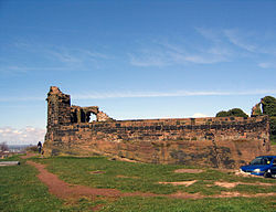
Part of the ruins of Halton Castle
Cheshire UK location map.svg
Red pog.svg
Halton
Location within Cheshire
Unitary authority
Ceremonial county
Region
Country England
Sovereign state United Kingdom
List of places
UK
England
Cheshire
53°19′52″N2°41′38″W / 53.331°N 2.694°W / 53.331; -2.694

Halton, formerly a separate village, is now part of the town of Runcorn, Cheshire, England. The name Halton has been assumed by the Borough of Halton, which includes Runcorn, Widnes, and some outlying parishes.

Contents

History

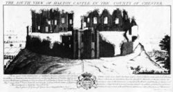
Halton Castle in 1727. Engraving by the Buck brothers Halton Castle engraving.jpg
Halton Castle in 1727. Engraving by the Buck brothers

There is evidence of human occupation in the Stone Age and during the Roman era. [1] The village [2] is recorded in the Domesday Book (1086) in the hundred of Tunendune [3] . Towards the end of the 11th century, the first castle, which became the seat of the Barons of Halton, was built on the hill. [4] The Tunendune hundred court was absorbed into Bucklow hundred by 1260 so government statistics for Halton over many later centuries are indexed by Bucklow hundred.

During the medieval period, a deer park measuring 100 acres (40 ha) lay to the south and the west of the village. At this time, Halton had a weekly market and annual fair. [5] The village held a court leet and the castle was used as a prison. [6] During the Civil War, the castle was held by the Royalists and twice besieged by Parliamentary forces. Following this the castle fell into ruin. [7] The importance of Halton declined with the coming of the Industrial Revolution and the development of the chemical and other industries in Runcorn. [8]

Halton was formerly a township and chapelry in the parish of Runcorn. [9] In 1866, Halton became a separate civil parish. [10] On 1 April 1967, the parish was abolished and merged with Runcorn. [11]

Geography

The village stands in an elevated position at 240 feet (73 m) compared with the surrounding area which lies at about 100 feet (30 m). At its centre is an outcrop of sandstone which rises to a height of 252.6 feet (77 m). [12] On the summit of the outcrop are the ruins of Halton Castle. The major road, Main Street, passes below the castle, to its west and south, and Castle Road leads up to the castle.

Demography

Population statistics were recorded separately for the parish of Halton until the village was incorporated into its larger neighbour under the Runcorn New Town (Designation) Order 1964.

The population of Halton Village in 1664 has been estimated as 375. [13] In 1961, the parish had a population of 1,467.

Population growth of Halton Village since 1801 [13] [14]
1801181118211831184118511861187118811891190119111921193119511961
6288941,0661,3221,3971,5701,5051,6201,4391,5551,2381,2941,5081,6941,4901,467

Today

St Mary's Church St Mary's Halton 2.jpg
St Mary's Church
Halton Trinity Methodist Church Halton Trinity Methodist Church - geograph.org.uk - 1200498.jpg
Halton Trinity Methodist Church

The village is now entirely residential, surrounded to the west and north by the estates of Runcorn New Town. To the south is Halton Lea, a shopping mall, and other retail and entertainment outlets. To the east is Town Park. The castle is a Grade I listed building and a scheduled ancient monument, and there are a number of other listed buildings in the village. There are two public houses, the Castle Hotel, which is incorporated into the structure of the castle and which contains the former courthouse, and the Norton Arms. In the village are two active churches, the Anglican Church of St Mary and Trinity Methodist Church. The Village has a Millennium Green, one of a series of 245 charity-run public green spaces created at the turn of the millennium.

See also

Related Research Articles

<span class="mw-page-title-main">Cheshire</span> County of England

Cheshire is a ceremonial county in North West England. It is bordered by Merseyside to the north-west, Greater Manchester to the north-east, Derbyshire to the east, Staffordshire to the south-east, and Shropshire to the south; to the west it is bordered by the Welsh counties of Flintshire and Wrexham, and has a short coastline on the Dee Estuary. Warrington is the largest settlement, and the city of Chester is the county town.

<span class="mw-page-title-main">Runcorn</span> Town in England

Runcorn is an industrial town and cargo port in the Borough of Halton, Cheshire, England. Its population in 2021 was 62,100. Runcorn is on the southern bank of the River Mersey, where the estuary narrows to form the Runcorn Gap. It lies on the southern shore of the River Mersey 15 miles upstream from the port of Liverpool.

<span class="mw-page-title-main">Daresbury</span> Village in Cheshire, England

Daresbury is a village and civil parish in the Borough of Halton, Cheshire, England. At the 2011 census, it had a population of 246.

<span class="mw-page-title-main">History of Cheshire</span> Overview of history of Cheshire

The history of Cheshire can be traced back to the Hoxnian Interglacial, between 400,000 and 380,000 years BP. Primitive tools that date to that period have been found. Stone Age remains have been found showing more permanent habitation during the Neolithic period, and by the Iron Age the area is known to have been occupied by the Celtic Cornovii tribe and possibly the Deceangli.

<span class="mw-page-title-main">Civil parishes in Cheshire</span>

A civil parish is a country subdivision, forming the lowest unit of local government in England. There are 333 civil parishes in the ceremonial county of Cheshire, most of the county being parished. Cheshire East unitary authority is entirely parished. At the 2001 census, there were 565,259 people living in 332 parishes, accounting for 57.5 per cent of the county's population.

<span class="mw-page-title-main">Antrobus, Cheshire</span> Human settlement in England

Antrobus is a civil parish and village in Cheshire, England, about 7 mi (11 km) south of Warrington. It lies within the unitary authority of Cheshire West and Chester, and had a population of 832, reducing to 791 at the 2011 Census, and to 767 in the 2021 Census. The parish is the most northeasterly point of Cheshire West and Chester, and as such borders both Warrington and Cheshire East. As well as Antrobus village centre itself, the parish includes other large hamlets at Frandley, about 1 mi (1.6 km) south-west from the main village, and Crowley, about 2 mi (3.2 km) to the north-east.

<span class="mw-page-title-main">Aston-by-Sutton</span> Human settlement in England

Aston is a village and civil parish in the unitary authority area of Cheshire West and Chester and the ceremonial county of Cheshire, England. According to the 2001 census it had a population of 111, reducing slightly to 106 at the 2011 census. The village is just outside the Runcorn urban area. From 1974 to 2009 it was in Vale Royal district.

<span class="mw-page-title-main">Wheelock, Cheshire</span> Human settlement in England

Wheelock is a large village in the civil parish of Sandbach which is in the unitary authority of Cheshire East and the ceremonial county of Cheshire, England. It is south of Sandbach on the road to Crewe. It was named after the River Wheelock.

<span class="mw-page-title-main">Barony of Halton</span>

The Barony of Halton, in Cheshire, England, comprised a succession of 15 barons and hereditary Constables of Chester under the overlordship of the Earl of Chester. It was not an English feudal barony granted by the king but a separate class of barony within the County Palatine of Chester.

<span class="mw-page-title-main">Halton Castle</span> Castle ruins in Cheshire, England

Halton Castle is a castle in the village of Halton, part of the town of Runcorn, Cheshire, England. The castle is on the top of Halton Hill, a sandstone prominence overlooking the village. The original building, a motte-and-bailey castle began in 1071, was replaced with the current sandstone castle in the 13th century. Building alterations continued until at least 1609, when the structure is recorded as in disrepair. The castle is recorded in the National Heritage List for England as a designated Grade I listed building, and a scheduled monument.

<span class="mw-page-title-main">Listed buildings in Runcorn (urban area)</span>

Runcorn is an industrial town in Halton, Cheshire, England, on the south bank of the River Mersey where it narrows at Runcorn Gap. In the town are the 61 buildings that are recorded in the National Heritage List for England as designated listed buildings in the current urban area of Runcorn, including the districts of Runcorn, Halton, Weston, Weston Point, and Norton. Two of these are classified as being in Grade I, nine in Grade II*, and 51 in Grade II.

<span class="mw-page-title-main">All Saints' Church, Daresbury</span> Church in Cheshire, England

All Saints' Church is in the village of Daresbury, Cheshire, England. It is known for its association with Lewis Carroll who is commemorated in its stained glass windows depicting characters from Alice's Adventures in Wonderland. It is recorded in the National Heritage List for England as a designated Grade II* listed building. The church is an active Church of England parish church in the diocese of Chester, the archdeaconry of Chester and the deanery of Great Budworth. The author Lewis Carroll was born in All Saints' Vicarage in 1832 when his father, Charles Dodgson, was perpetual curate at the church. This was commemorated in March 2012 when the Lewis Carroll Centre, attached to the church, was opened.

<span class="mw-page-title-main">Listed buildings in Widnes</span>

Widnes is an industrial town in the Borough of Halton, Cheshire, England, on the north bank of the River Mersey where it narrows at Runcorn Gap. The town contains 24 buildings that are recorded in the National Heritage List for England as designated listed buildings. Of these, 5 are classified at Grade II*, and the rest are at Grade II; Widnes has no Grade I listed buildings. In the United Kingdom, the term "listed building" refers to a building or other structure officially designated as being of special architectural, historical, or cultural significance. Listed buildings are categorised in three grades: Grade I consists of buildings of outstanding architectural or historical interest; Grade II* includes particularly significant buildings of more than local interest; Grade II consists of buildings of special architectural or historical interest. Buildings in England are listed by the Secretary of State for Culture, Media and Sport on recommendations provided by English Heritage, which also determines the grading.

<span class="mw-page-title-main">St John the Evangelist's Church, Weston</span> Church in Cheshire, England

St John the Evangelist's Church is in Weston, once a separate village and now part of the town of Runcorn, Cheshire, England. The church is recorded in the National Heritage List for England as a designated Grade II* listed building. It is an active Anglican parish church in the diocese of Chester, the archdeaconry of Chester and the deanery of Frodsham. Its design has been described as "bold and original".

<span class="mw-page-title-main">St Mary's Church, Halton</span> Church in Cheshire, England

St Mary's Church is in Halton, which was formerly a separate village, but is now part of the town of Runcorn, Cheshire, England. It is an active Anglican parish church in the diocese of Chester, the archdeaconry of Chester and the deanery of Frodsham. The church is recorded in the National Heritage List for England as a designated Grade II listed building.

<span class="mw-page-title-main">All Saints' Church, Runcorn</span> Church in Cheshire, England

All Saints' Church is the parish church of Runcorn, Cheshire, England, sited on the south bank of the River Mersey overlooking Runcorn Gap. There is a tradition that the first church on the site was founded by Ethelfleda in 915. That was replaced, probably in about 1250, by a medieval church that was altered and extended in the 14th and 15th centuries. By the 19th century the building's structure had deteriorated and become dangerous, and it was replaced by a new church, built between 1847 and 1849 to the designs of Anthony Salvin.

<span class="mw-page-title-main">Millington, Cheshire</span> Human settlement in England

Millington is a former civil parish, now in the parishes of Millington and Rostherne and Little Bollington with Agden, in the Cheshire East district, in the ceremonial county of Cheshire, England. The parish was 8 miles (13 km) from Warrington and 3 miles (5 km) from Altrincham. Its name is a "relic of Saxon clanship – the ton or town of the Millings". The parish is primarily agricultural, with a number of farms including Moss House Farm, Newhall Farm, Mereside Farm, Boothbank Farm and Stonedelph Farm. Millington has been recently described on Britain Streets as a "hamlet or isolated settlement in the inhabited countryside". Millington is situated within the market town Macclesfield. The M56 motorway was close to the parish, which allows travel into areas of Warrington and Manchester, 13 miles (21 km) and 14 miles (23 km) away respectively. In 2011 the parish had a population of 234.

<span class="mw-page-title-main">Norton, Runcorn</span> Human settlement in England

Norton is an area in the eastern part of the town of Runcorn, in the Halton district, in the ceremonial county of Cheshire, England. It was originally a separate village 3 miles (5 km) to the east of Runcorn, but in the 1970s and 1980s became absorbed within Runcorn by the expansion of its new town.

<span class="mw-page-title-main">Weston, Runcorn</span> Human settlement in England

Weston or Weston Village is a settlement in the Halton district, in the ceremonial county of Cheshire, England. Formerly a separate village, it is now part of the town of Runcorn.

There are over 9,000 Grade I listed buildings and 20,000 Grade II* listed buildings in England. This page is a list of these buildings in the borough of Halton in Cheshire.

References

Notes

  1. Starkey 1990 , pp. 1–4.
  2. "Halton | Domesday Book". Archived from the original on 2 February 2015. Retrieved 2 February 2015. Domesday Map Online: Halton
  3. Domesday Map Online: Tunendune Hundred
  4. Starkey 1990 , pp. 7–8.
  5. Starkey 1990 , pp. 19–21.
  6. Starkey 1990 , pp. 25–28.
  7. Starkey 1990 , pp. 57–58.
  8. Starkey 1990 , pp. 147ff.
  9. "History of Halton in Cheshire". A Vision of Britain through Time . Retrieved 2 May 2024.
  10. "Relationships and changes Halton CP/Ch through time". A Vision of Britain through Time. Retrieved 2 May 2024.
  11. "Runcorn Registration District". UKBMD. Retrieved 2 May 2024.
  12. Height, EarthTools, archived from the original on 1 April 2012, retrieved 6 November 2008
  13. 1 2 "Cheshire Historic Towns Survey - Runcorn and Halton Archaeological Assessment" (PDF). Cheshire County Council and English Heritage. Retrieved 12 July 2020.
  14. "Halton Ch/CP through time - Population Statistics". University of Portsmouth. Retrieved 13 July 2020.

Bibliography

  • Starkey, H. F. (1990), Old Runcorn, Halton: Halton Borough Council