| Halton | |
|---|---|
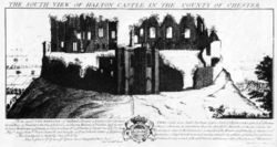
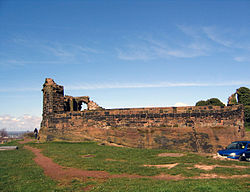 Part of the ruins of Halton Castle | |
 Halton Location within Cheshire | |
| Unitary authority | |
| Ceremonial county | |
| Region | |
| Country | England |
| Sovereign state | United Kingdom |
Halton, formerly a separate village, is now part of the town of Runcorn, Cheshire, England. The name Halton has been assumed by the Borough of Halton, which includes Runcorn, Widnes, and some outlying parishes.