Runcorn is an industrial town in Halton, Cheshire, England, on the south bank of the River Mersey where it narrows at Runcorn Gap. In the town are the 61 buildings that are recorded in the National Heritage List for England as designated listed buildings in the current urban area of Runcorn, including the districts of Runcorn, Halton, Weston, Weston Point, and Norton. Two of these are classified as being in Grade I, nine in Grade II*, and 51 in Grade II.
In the United Kingdom, the term "listed building" refers to a building or other structure officially designated as being of special architectural, historical or cultural significance. These buildings are in three grades: Grade I consists of buildings of outstanding architectural or historical interest; Grade II* includes particularly significant buildings of more than local interest; Grade II consists of buildings of special architectural or historical interest. Buildings in England are listed by the Secretary of State for Culture, Media and Sport on recommendations provided by English Heritage, which also determines the grading. [1]
Before the Industrial Revolution, the area contained the separate settlements of Runcorn, Higher Runcorn, Halton, Weston, Weston Point, and Norton. The administrative functions of the area were initially concentrated in Halton, [2] which contained a castle and a court, while the parish church was in Runcorn. [3] The population increase associated with industrialisation resulted in considerable expansion, so that the formerly discrete settlements were absorbed into the current urban area, much of which dates from the 19th and 20th centuries. [4] The listed buildings are concentrated in Halton Village, which has 20, and Runcorn Town Centre, which has 16.
The listed buildings can be divided by date into three groups: ancient structures, structures built during the two centuries before the Industrial Revolution, and those built during or after it.
Halton Castle and Norton Priory date from the 11th and 12th centuries, and are now in ruins. Structures built before the Industrial Revolution reflect society as it was at that time, and the main occupations of farming and fishing. They include farmhouses, such as the building known as the Seneschal's House, which dates from 1598 and is the oldest standing building in the urban area; buildings relating to stately homes, such as the loggia and ice house in the grounds of Norton Priory; domestic buildings, such as Halton Old Hall, and buildings relating to the church, such as Halton Vicarage and the adjacent Chesshyre Library.
The diversity of Runcorn's buildings increased during the Industrial Revolution. Structures such as Bridgewater House were associated with industry, while large domestic buildings such as Halton Grange were financed by the new wealth created. The enlarged town required new civic buildings such as the Old Police Station (originally a Town Hall) and transport infrastructure such as the railway bridge and the tide dock, while the needs of the growing population were met by structures such as Norton Water Tower. All of the listed churches were built in the 19th century; architects include John Douglas, Anthony Salvin, Sir George Gilbert Scott, and Edmund Sharpe. The most recent listed structure is the Silver Jubilee Bridge, constructed in 1961.
Except for the iron or steel included in the bridges and the water tower, the structures are built in brick or stone. The stone is almost invariably red sandstone, obtained from local quarries in the Runcorn, Weston, and Halton areas. [5] Unless stated otherwise, the buildings (except the bridges and the water tower) are constructed in local red sandstone with slate roofs. Their locations can be found on the map of all coordinates.
Grade | Criteria [6] |
---|---|
I | Buildings of exceptional interest, sometimes considered to be internationally important |
II* | Particularly important buildings of more than special interest |
II | Buildings of national importance and special interest |
Name | Photograph | Grade | Date | Location | Description |
---|---|---|---|---|---|
Halton Castle | I | 1070 and later | Halton 53°20′00″N2°41′45″W / 53.3332°N 2.6957°W | Built after the Norman Conquest, the castle became the seat of the Barons of Halton. It was besieged twice during the Civil War and subsequently fell into ruin. In about 1800, additional walls were built on its east side to improve its appearance from Norton Priory. It is a scheduled monument, owned by the Duchy of Lancaster and managed by the Norton Priory Museum Trust. [7] [8] [9] [10] [11] [12] [13] | |
Norton Priory | I | 1115 and later | Norton Priory 53°20′33″N2°40′47″W / 53.3424°N 2.6796°W | This former Augustinian Priory, later an abbey, was reduced to a ruin following the dissolution of the monasteries. A Tudor mansion house was built on the site by Richard Brooke; this was replaced by a Georgian house in 1730. The latter house was demolished in 1928. The site is now a museum which consists of the remains of the priory, including a Norman undercroft with a doorway of 1180 and a Victorian copy, and two blind Norman arcades. It is a scheduled monument and is managed by the Norton Priory Museum Trust. [14] [15] [16] [17] [18] [19] | |
Seneschal's House | II* | 1598 | Halton 53°20′06″N2°41′45″W / 53.3350°N 2.6957°W | This is the oldest standing building in Runcorn. The house is E-shaped and its gables have corbels, moulded copings and sandstone ridges with ball finials. [20] [21] It was latterly a farmhouse although originally built and inhabited by the judge John King in the late 16th century in recognition of which Geoffrey Barraclough renamed the property The Seneschal's House.[ citation needed ] | |
Halton Old Hall | II* | 1693 | Halton 53°19′56″N2°41′36″W / 53.3322°N 2.6933°W | This is a house which was rebuilt after having been damaged in the English Civil War. A two-storey wing was later added to the north. The house has mullion windows and a studded door. [22] | |
Tricorn Public House, formerly Hallwood | II* | c. 1710 | Palacefields 53°19′19″N2°41′28″W / 53.3219°N 2.6910°W | Now a public house, this was formerly a wing of a mansion house called Hallwood, the birthplace and home of Sir John Chesshyre. It is in brown brick and stone with a slate roof. [23] [24] [25] [26] | |
Chesshyre Library | II* | 1730 | Halton 53°19′55″N2°41′44″W / 53.3319°N 2.6956°W | The library was built for the incumbent of St Mary's Church by Sir John Chesshyre. Its doorcase is surrounded by Ionic columns with a triangular pediment. The roof has a cornice, a solid parapet, stone gables, and a chimney. Since 1975, it has been linked to the church hall and used as a meeting room. [20] [27] [28] [29] | |
Castle Hotel | II* | 1737 | Halton 53°19′59″N2°41′45″W / 53.3330°N 2.6957°W | This building was originally integrated into the walls of the castle and used as a court house. The court room was on the first floor and prisoners were housed in the cellars. The entrance to the court room is approached by an external stone staircase, and its doorcase is surmounted by the Royal Arms. It is now a public house. [20] [30] [31] | |
Halton Vicarage | II* | 1739 | Halton 53°19′55″N2°41′44″W / 53.3320°N 2.6956°W | The vicarage was paid for by Sir John Chesshyre. On its front are pilasters and a Doric porch. The windows are sash windows. The eaves consist of a cornice with a solid parapet, which is pedimented over the centre bay. It is still in use as a vicarage. [20] [32] [33] | |
All Saints Church | II* | 1849 | Runcorn Town Centre 53°20′37″N2°44′12″W / 53.3435°N 2.7366°W | Built on the site of an earlier medieval church, the parish church of Runcorn was designed in Early English style by Anthony Salvin. It consists of a five-bay nave with aisles, a chancel which is reduced in both width and height, and a tower with a spire at the southwest corner of the nave. [34] [35] [36] | |
Runcorn Railway Bridge | II* | 1868 | Runcorn Town Centre 53°20′48″N2°44′18″W / 53.3468°N 2.7383°W | Spanning the River Mersey to provide a more direct rail connection between London and Liverpool, the bridge is constructed of iron girders on sandstone piers. It is approached on each side by arched viaducts. At both ends of the bridge are square towers with crenellations and machicolations. The structure was designed by William Baker and now carries the Liverpool branch of the West Coast Main Line. [37] [38] [39] [40] | |
St John's Church | II* | 1897 | Weston 53°19′08″N2°44′20″W / 53.3190°N 2.7388°W | St John's Church has a short broach spire, a nave, and a chancel at a higher level, with the vestry below. It was designed by John Douglas. Some of the money for its construction was raised by the choirboys, who wrote appeal letters; it is therefore sometimes known as "the choirboys' church". St John's became a separate parish in 1931. [41] [42] [43] | |
Weston Cross | II | Medieval | Weston 53°19′09″N2°44′23″W / 53.31919°N 2.73967°W | This contains the former steps to a market cross. It consists of a square base, two steps high, to which a third modern step was added when the present Celtic-style cross was erected in 1960. [44] | |
Weston Old Hall and barn | II | 1607 | Weston 53°19′03″N2°44′18″W / 53.3176°N 2.7383°W | This former farmhouse and the barn sited behind it are listed separately as Grade II. The house has four bays; the outer bays project forwards and the third bay contains the porch. The windows have mullions. The roof of the barn has gable copings and a blue-tile ridge. [45] [46] [47] | |
Cavendish Farm House | II | c. 1622 | Weston 53°19′05″N2°44′14″W / 53.31817°N 2.73709°W | This former farmhouse is built on an L-plan. The wing has a ten-light double chamfered mullion window on both storeys. The windows elsewhere are mostly of three lights. [48] | |
125 and 127 Main Street | II | Early 17th century | Halton 53°19′50″N2°41′34″W / 53.33042°N 2.69286°W | This was a pair of two-storey cottages that has been combined into one house. Its lower storey is in sandstone, while the upper storey is timber-framed with rendered infill. [49] | |
Manor Farm House | II | Early 17th century | Weston 53°19′05″N2°44′20″W / 53.31818°N 2.73895°W | This former farmhouse has a single stone-mullioned window in the attic. [50] | |
Village Farm House, 45 Main Street | II | Early 17th century | Halton 53°19′58″N2°41′51″W / 53.3329°N 2.6975°W | This was formerly a farmhouse. It has mullion windows that contain leaded lights. At the first-floor level and above the first-floor window are string courses. A later section to the north is in random rubble. [51] | |
Rock Farm House | II | 17th century | Halton 53°19′52″N2°41′42″W / 53.33098°N 2.69497°W | This former farmhouse has mullion windows. A newer addition to its east is in brick on old sandstone foundations. [52] | |
Brookfield Farm, 2 Weston Road | II | 1691 | Higher Runcorn 53°20′01″N2°44′22″W / 53.3337°N 2.7395°W | This farmhouse is in stone with a brick gable and has a machine-tile roof. An original stone mullion window is still present on the ground floor on the west front. The original entrance has been filled in and a new entrance built. [53] | |
Borrow's Bridge and crane | II | c. 1700 | Norton 53°19′45″N2°39′34″W / 53.32921°N 2.65957°W | The bridge is an accommodation bridge, and is bridge No. 69 over the Bridgewater Canal. It is in red brick with gritstone dressings, and consists of a single segmental arch. The bridge has voussoirs, a sandstone band, and splayed abutments. Adjacent to the bridge is a hand-cranked crane in cast iron that has a moulded framed and panelled side plates, external cog wheels, a cable drum, and a tubular jib ending in a pulley wheel. [54] | |
Former stables of Hallwood | II | c. 1710 | Palacefields 53°19′20″N2°41′27″W / 53.3223°N 2.6909°W | This building was formerly the stables of Hallwood. Its façade includes five giant Doric pilasters and two pedimented doorways. On the lower floor are five sash windows, and on the upper floor the windows are round. It is now used as a function room for the adjacent public house. [26] [55] | |
6, 8 and 10 Castle Road | II | Early 18th century | Halton 53°19′54″N2°41′42″W / 53.3317°N 2.6951°W | This row of three cottages has sash windows. One chimney stack is in stone. [56] | |
53 and 55 High Street | II | Early 18th century | Runcorn Town Centre 53°20′29″N2°43′59″W / 53.3413°N 2.7330°W | This is a town house in Georgian style. It is in red brick with stone dressings and has a slate roof. In the 19th century, it was the home of Thomas Hazlehurst, a soap and alkali maker, and is now used by the adjoining bank and as a solicitors' office. [57] [58] [59] | |
Hollybank House, 51 Main Street | II | Early 18th century | Halton 53°19′56″N2°41′51″W / 53.33231°N 2.69745°W | This house is in rendered brick with a slate roof. It has a moulded stone plinth and rusticated quoins. The stone doorcase has Ionic pilasters, a pulvinated frieze, and a swan-neck pediment with a cartouche in the tympanum. [60] | |
Norton Lodge | II | Early 18th century | Norton 53°20′00″N2°40′05″W / 53.33326°N 2.66795°W | This house is in brown brick on a stone plinth. It has a timber doorcase with a rectangular fanlight, a pulvinated frieze and a pediment. [61] | |
Gates of Chesshyre Library | II | c. 1730 | Halton 53°19′55″N2°41′44″W / 53.3319°N 2.6956°W | The gate piers in the wall fronting the entrance to the Chesshyre Library consist of squared sandstone blocks with ball finials. The piers are set in an ashlar wall. [62] | |
The Elms, 4 Weston Road | II | Mid 18th century | Higher Runcorn 53°20′03″N2°44′24″W / 53.3341°N 2.7401°W | This town house in red brick with a slate roof is in the Georgian style. It has a moulded plinth and rusticated quoins. The segmental pedimented Doric doorcase has fluted pilasters and triglyphs. [63] | |
The Nook, 5 Weston Road | II | Mid 18th century | Higher Runcorn 53°20′02″N2°44′27″W / 53.3338°N 2.7409°W | This house is constructed in roughcast stone and brickwork, under a slate roof with a sandstone ridge. The stone doorcase has a moulded architrave and a stone arch with a keystone. [64] | |
Ice House, Norton Priory | II | 18th century | Norton Priory 53°20′48″N2°40′54″W / 53.3467°N 2.6817°W | This ice house stands adjacent to the walled garden of Norton Priory. It is in brick under an earth mound. It is beehive-shaped and is approached along a short tunnel, which leads into a circular domed chamber. [65] | |
Norton Arms Public House | II | 1758 | Halton 53°20′05″N2°41′44″W / 53.3346°N 2.6956°W | This is a public house built in roughcast brickwork on a stone moulded plinth with rusticated quoins and a slate roof. The stone doorcase has plain pilasters, moulded caps, and an archivolt with a keystone. [66] | |
Bridgewater House | II | 1760s | Runcorn Dock 53°20′33″N2°44′45″W / 53.3424°N 2.7459°W | This was originally a mansion house built to provide accommodation for the Duke of Bridgewater when he was supervising the construction and administration of the Bridgewater Canal. It is in brown brick with a slate roof and has a stone Doric doorcase. It has been converted into use as offices. [57] [67] [68] [69] | |
Weston Grange | II | 1766 | Weston 53°19′10″N2°44′23″W / 53.31943°N 2.73986°W | This house is in roughcast brick with a slate roof on a stone plinth, and it has rusticated quoins. The stone pedimented doorcase has a pulvinated frieze and a decorative inscribed tympanum. There are stone copings to the roof gables. [70] | |
Tide dock and lock | II | c. 1772 | Runcorn Dock 53°20′36″N2°44′44″W / 53.3432°N 2.7455°W | This structure consists of a tide dock together with the retaining walls of a lock. The opening was originally into the River Mersey but following the construction of the Manchester Ship Canal it now opens into the canal. It is in sandstone blocks and there have since been some repairs in brick and concrete. [71] | |
31 Main Street | II | Late 18th century | Halton 53°20′02″N2°41′48″W / 53.33392°N 2.69673°W | This building was formerly the stables to Halton House. Its ground floor has three Gothic windows with rendered surrounds, stone sills, and cast iron lattice casement windows. At the first-floor level there is a square pitch hole. The roof was raised in the 1960s and the building is now used as a dwelling. [72] | |
58 High Street | II | Late 18th century | Runcorn Town Centre 53°20′29″N2°44′06″W / 53.3414°N 2.7351°W | This was originally a cottage built in brown brick with a slate roof. The doorcase has stone Tuscan columns and an open pediment. The building has been converted into use as a shop. [73] | |
71 High Street | II | Late 18th century | Runcorn Town Centre 53°20′29″N2°44′02″W / 53.3413°N 2.7340°W | This town house is in red brick and has a slate roof. It stands on a stone plinth and has a stone Tuscan doorcase with an open pediment and a patterned arched fanlight above. It has been converted for business use. [74] | |
Garden Loggia, Norton Priory | II | Late 18th century | Norton Priory 53°20′30″N2°40′48″W / 53.34162°N 2.68012°W | The loggia is in yellow sandstone, with some brickwork, in the former garden of Norton Priory house. It has two Doric columns and antae at the front of the side walls. [75] | |
Rockfield, 7 Weston Road | II | Late 18th century | Higher Runcorn 53°20′02″N2°44′30″W / 53.3338°N 2.7416°W | This house is constructed in rendered brickwork with a slate roof. The stone Doric doorcase has an open pediment and a radial bar fanlight. [76] | |
Royal Hotel | II | Late 18th century | Runcorn Town Centre 53°20′32″N2°43′49″W / 53.3422°N 2.7303°W | This hotel at the east end of High Street was formerly known as the White Hart, and was a meeting place for members of local government before a town hall was built. It is in brown brick and has a slate roof. [77] [78] | |
53 Holloway | II | 1779 | Higher Runcorn 53°20′04″N2°44′25″W / 53.3344°N 2.7404°W | This brown-brick house has a slate roof, a stone plinth and quoins. The pedimented stone doorcase has an architrave and a frieze. Its entrance door is studded. [79] | |
Halton House, 33 Main Street | II | 1779 | Halton 53°20′02″N2°41′49″W / 53.33384°N 2.69695°W | This house is in brown brick with a sandstone slate roof. The walls have rusticated stone quoins. The doorcase is in stone with eared architraves, a pulvinated frieze, and a pediment with an inscribed tympanum. [80] | |
12, 14 and 16 Castle Road | II | Early 19th century | Halton 53°19′54″N2°41′42″W / 53.3318°N 2.6951°W | This row of three cottages is in brown brick with slate roofs. The cottages are on a stone plinth; they have quoins, and horizontal-sliding sash windows. [81] | |
59, 61 and 63 Main Street | II | Early 19th century | Halton 53°19′51″N2°41′45″W / 53.33096°N 2.69579°W | This row of three houses is in red brick with a slate roof on a stone plinth. The doorcases have Tuscan columns with elliptical fanlights and rubbed arches. [82] | |
88, 90, 92 and 94 Main Street | II | 1827 | Halton 53°19′50″N2°41′35″W / 53.33066°N 2.69319°W | This row of four cottages is in red brick on a sandstone plinth and has a slate roof. [83] | |
Waterloo Bridge | II | 1828 | Runcorn Town Centre 53°20′26″N2°44′19″W / 53.3405°N 2.7387°W | This road bridge over the Bridgewater Canal has three arches. A sidewalk and a parapet were added in 1886. The bridge is constructed in red sandstone with a cast iron balustraded parapet. [84] [85] | |
Old Police Station | II | 1831 | Runcorn Town Centre 53°20′32″N2°43′47″W / 53.3423°N 2.7298°W | This was Runcorn's first town hall. It later became a police station, with cells in the basement, and a magistrates' court. The façade is of red sandstone and the rest of the building is in brick with a slate roof. Its entrance is flanked by Ionic pilasters carrying a frieze and a pediment. It has been converted into use as offices. [86] [87] | |
Hearse House | II | c. 1833 | Runcorn Town Centre 53°20′35″N2°44′09″W / 53.3430°N 2.7359°W | The building stands in the grounds of the parish church and was used to house hearses. It has been converted into use as an electrical substation. [88] | |
Norton Priory Lodge, 120 Main Street | II | Early–mid 19th century | Halton 53°19′49″N2°41′26″W / 53.33037°N 2.69050°W | Originally a lodge to Norton Priory, this is now a private dwelling. It has two-light mullion windows flanking a built-up door opening. The eaves cornice rests on large stone brackets and the roof is hipped. [89] | |
Holy Trinity Church | II | 1838 | Runcorn Town Centre 53°20′32″N2°43′42″W / 53.3422°N 2.7282°W | This church was built in 1838 and the chancel was added in 1857. It consists of a five-bay nave with a narrower chancel, and there is a tower at the west end. [90] [91] [92] | |
Christ Church and railings, Weston Point | II | 1841 | Weston Point 53°19′43″N2°45′40″W / 53.3287°N 2.7611°W | A church, now redundant, that was built by the Trustees of the Weaver Navigation for its employees. It is designed in Early English style and has a broach spire. The railings surrounding the church are included in the listing. The architect was Edmund Sharpe. The church is now situated in the Port of Runcorn and is inaccessible to the public. [91] [93] [94] [95] | |
St Mary's Church | II | 1851 | Halton 53°19′55″N2°41′47″W / 53.3320°N 2.6963°W | St Mary's Church was built to replace an ancient chapel. It was designed by Sir George Gilbert Scott, and stands in a prominent position on Halton Hill near the castle. The church has a four-bay nave with aisles, and its chancel is at a lower level. There is an octagonal bell turret above the junction of the nave and chancel. St Mary's became a separate parish in 1860. [13] [96] [97] | |
Town Hall, formerly Halton Grange | II | 1856 | Runcorn Heath Road 53°20′01″N2°43′26″W / 53.3336°N 2.7238°W | This was built as a mansion house, Halton Grange, for Thomas Johnson, a local soap and alkali manufacturer, in the style of an Italianate villa with a belvedere tower. Its exterior is rendered and it has a slate roof. At its entrance is a Tuscan portico with an open balustrade above. It now forms part of Runcorn Town Hall. [98] [99] [100] | |
Red Lodge, Manor Farm Road | II | 1870 | Norton 53°20′56″N2°40′03″W / 53.34894°N 2.66740°W | The lodge was at the northeast approach to Norton Priory. It was built for Sir Richard Brooke, 7th Baronet of Norton Priory, and has since been converted into a private house. The lodge is in Tudor Revival style. It has an irregular cruciform plan and two storeys, the lower storey being in red sandstone, and the upper in painted brick and timber framing. On each side is a gabled bay with a jettied upper floor. The boundary fencing, the gates, and the gate piers are included in the listing. [101] | |
NatWest Bank, High Street | II | Late 19th century | Runcorn Town Centre 53°20′29″N2°43′58″W / 53.3414°N 2.7328°W | The bank is in red brick with polished granite columns flanking the entrance. It has a parapeted roof. [102] | |
Walls, piers and railings, St Paul's Health Centre, High Street | II | Late 19th century | Runcorn Town Centre 53°20′29″N2°43′57″W / 53.3414°N 2.7325°W | These stone and cast iron structures originally formed the entrance to a Methodist chapel, which has been replaced by a health centre. [103] | |
Norton Water Tower | II | 1892 | Norton 53°19′46″N2°40′17″W / 53.3294°N 2.6714°W | This is a cylindrical balancing reservoir on the water pipeline from Lake Vyrnwy to Liverpool. Ten pilasters on its outer surface rise to a frieze which carries a Latin inscription. The tower is surmounted by a decorated iron tank. [104] [105] [106] | |
Old Quay Bridge | II | c. 1894 | Runcorn Town Centre 53°20′39″N2°43′19″W / 53.3441°N 2.7220°W | This swing bridge over the Manchester Ship Canal links Runcorn with Wigg Island. It is operated from the south bank of the canal by means of a hydraulic system. This is operated from machinery in a group of three slate-roofed red-brick buildings, an engine house, an accumulator tower and the control building. [107] | |
Carnegie Library | II | 1906 | Runcorn Town Centre 53°20′31″N2°44′15″W / 53.3420°N 2.7374°W | This purpose-built library in Egerton Street was constructed with a grant from Andrew Carnegie. It includes Mackintosh-style stained glass windows. Inside is an ornate cast iron spiral staircase. It was listed in 2007. [108] [109] | |
War Memorial | II | 1920 | Higher Runcorn 53°20′00″N2°44′20″W / 53.33343°N 2.73882°W | The war memorial was built to commemorate those lost in the First World War, and the names of those lost in later conflicts were subsequently added. It stands in a small garden, and consists of a Latin cross in white granite on a pedestal and steps. Behind it is a wall containing plaques with inscriptions and the names of those lost. [110] | |
Runcorn signal box | II | 1940 | Runcorn Town Centre 53°20′14″N2°44′19″W / 53.3373°N 2.7387°W | The signal box is at the south end of Runcorn railway station. It was built for the London, Midland and Scottish Railway early in the Second World War, and was designed to minimise blast damage from aerial bombing. It is constructed in brick with steel-framed windows set in concrete, and has a reinforced concrete roof. It was listed in 2013. [111] | |
Silver Jubilee Bridge | II | 1961 | Runcorn Town Centre 53°20′47″N2°44′16″W / 53.3463°N 2.7379°W | This road bridge crosses the River Mersey and links Runcorn with Widnes, replacing the Widnes–Runcorn Transporter Bridge. It is a through arch bridge which carries a four-lane carriageway and a cantilevered footway to the east. Its span is 1,082 feet (330 m) and its total length is 1,628 feet (496 m). [4] [112] [113] [114] | |
Runcorn is an industrial town and cargo port in the Borough of Halton, Cheshire, England. Its population in 2021 was 62,100. Runcorn is on the southern bank of the River Mersey, where the estuary narrows to form the Runcorn Gap.
Halton, formerly a separate village, is now part of the town of Runcorn, Cheshire, England. The name Halton has been assumed by the Borough of Halton, which includes Runcorn, Widnes and some outlying parishes.
The Abbey of St. Mary at Stanlaw, was a Cistercian foundation situated on Stanlaw - now Stanlow Point, on the banks of the River Mersey in the Wirral Peninsula, Cheshire, England, near Ellesmere Port, 11 km north of Chester Castle and 12 km south-west of Halton Castle.
Norton Priory is a historic site in Norton, Runcorn, Cheshire, England, comprising the remains of an abbey complex dating from the 12th to 16th centuries, and an 18th-century country house; it is now a museum. The remains are a scheduled ancient monument and are recorded in the National Heritage List for England as a designated Grade I listed building. They are considered to be the most important monastic remains in Cheshire.
The Barony of Halton, in Cheshire, England, comprised a succession of 15 barons and hereditary Constables of Chester under the overlordship of the Earl of Chester. It was not an English feudal barony granted by the king but a separate class of barony within the County Palatine of Chester.
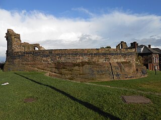
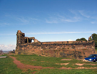
Halton Castle is a castle in the village of Halton, part of the town of Runcorn, Cheshire, England. The castle is on the top of Halton Hill, a sandstone prominence overlooking the village. The original building, a motte-and-bailey castle began in 1071, was replaced with the current sandstone castle in the 13th century. Building alterations continued until at least 1609, when the structure is recorded as in disrepair. The castle is recorded in the National Heritage List for England as a designated Grade I listed building, and a scheduled ancient monument.
All Saints' Church is in the village of Daresbury, Cheshire, England. It is known for its association with Lewis Carroll who is commemorated in its stained glass windows depicting characters from Alice's Adventures in Wonderland. It is recorded in the National Heritage List for England as a designated Grade II* listed building. The church is an active Church of England parish church in the diocese of Chester, the archdeaconry of Chester and the deanery of Great Budworth. The author Lewis Carroll was born in All Saints' Vicarage in 1832 when his father, Charles Dodgson, was perpetual curate at the church. This was commemorated in March 2012 when the Lewis Carroll Centre, attached to the church, was opened.
Widnes is an industrial town in the Borough of Halton, Cheshire, England, on the north bank of the River Mersey where it narrows at Runcorn Gap. The town contains 24 buildings that are recorded in the National Heritage List for England as designated listed buildings. Of these, 5 are classified at Grade II*, and the rest are at Grade II; Widnes has no Grade I listed buildings. In the United Kingdom, the term "listed building" refers to a building or other structure officially designated as being of special architectural, historical, or cultural significance. Listed buildings are categorised in three grades: Grade I consists of buildings of outstanding architectural or historical interest; Grade II* includes particularly significant buildings of more than local interest; Grade II consists of buildings of special architectural or historical interest. Buildings in England are listed by the Secretary of State for Culture, Media and Sport on recommendations provided by English Heritage, which also determines the grading.
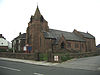
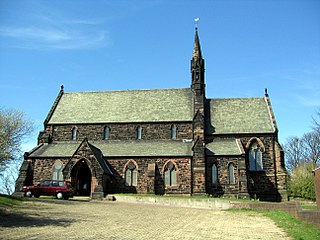
St John the Evangelist's Church is in Weston, once a separate village and now part of the town of Runcorn, Cheshire, England. The church is recorded in the National Heritage List for England as a designated Grade II* listed building. It is an active Anglican parish church in the diocese of Chester, the archdeaconry of Chester and the deanery of Frodsham. Its design has been described as "bold and original".
St Mary's Church is in Halton, which was formerly a separate village, but is now part of the town of Runcorn, Cheshire, England. It is an active Anglican parish church in the diocese of Chester, the archdeaconry of Chester and the deanery of Frodsham. The church is recorded in the National Heritage List for England as a designated Grade II listed building.
All Saints' Church is the parish church of Runcorn, Cheshire, England, sited on the south bank of the River Mersey overlooking Runcorn Gap. There is a tradition that the first church on the site was founded by Ethelfleda in 915. That was replaced, probably in about 1250, by a medieval church that was altered and extended in the 14th and 15th centuries. By the 19th century the building's structure had deteriorated and become dangerous, and it was replaced by a new church, built between 1847 and 1849 to the designs of Anthony Salvin.
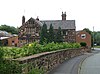
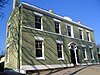
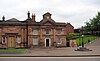
Runcorn Town Hall is in Heath Road, Runcorn, Cheshire, England. It is recorded in the National Heritage List for England as a designated Grade II listed building. It was originally built as Halton Grange, a mansion for Thomas Johnson, a local industrialist. After passing through the ownership of two other industrialists, it was purchased in the 1930s by Runcorn Urban District Council and converted into their offices. Since 1974, it has been the meeting place for Halton Borough Council.
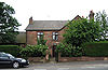
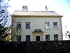
Bridgewater House is in the Old Coach Road, Runcorn, Cheshire, England. It is recorded in the National Heritage List for England as a designated Grade II listed building. Originally built for the use of the Duke of Bridgewater, it has since has been used for various purposes and has now been converted into offices.
Christ Church is a former Anglican parish church, now redundant, at Weston Point Docks, Runcorn, Cheshire, England. It is recorded in the National Heritage List for England as a designated Grade II listed building.
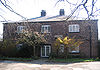
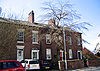
Hallwood is a former mansion house in Runcorn, Cheshire, England. One wing of the house remains and was a public house called the Tricorn until its closure in 2017. Its former stables were converted into a function room for the public house. The remaining wing of Hallwood is recorded in the National Heritage List for England as a designated Grade II* listed building; the former stables are listed at Grade II.
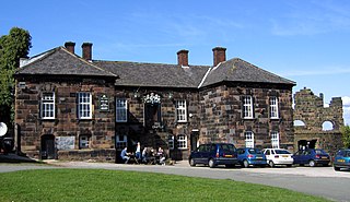
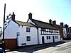
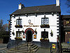
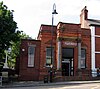
The Castle, formerly known as The Castle Hotel, is a public house and former Georgian courthouse on Halton Hill in Halton, Runcorn, Cheshire, England. Its side walls are continuous with the curtain walls of the ruins of Halton Castle. It is recorded in the National Heritage List for England as a designated Grade II* listed building.
Runcorn is an industrial town in the borough of Halton, Cheshire, England. This list contains the 27 buildings that are recorded in the National Heritage List for England as designated listed buildings in the part of the borough lying to the south of the River Mersey outside the urban area of Runcorn. The area covered includes the villages of Clifton, Daresbury, Preston Brook, Preston on the Hill, and Moore. Three of the buildings in the area are classified as Grade II*, and the others are at Grade II; there are no buildings in Grade I. In the United Kingdom, the term listed building refers to a building or other structure officially designated as being of special architectural, historical, or cultural significance. These buildings are in three grades: Grade I consists of buildings of outstanding architectural or historical interest; Grade II* includes particularly significant buildings of more than local interest; Grade II consists of buildings of special architectural or historical interest. Buildings in England are listed by the Secretary of State for Culture, Media and Sport on recommendations provided by English Heritage, which also determines the grading.
There are over 9,000 Grade I listed buildings and 20,000 Grade II* listed buildings in England. This page is a list of these buildings in the borough of Halton in Cheshire.
There are over 9,000 Grade I listed buildings in England. This page is a list of these buildings in the unitary authority of Cheshire West and Chester.
Citations
Sources