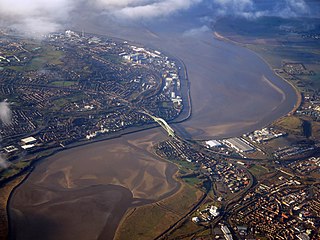
Halton is a unitary authority district with borough status in Cheshire, North West England. It was created in 1974 as a district of the non-metropolitan county of Cheshire, and became a unitary authority area on 1 April 1998 under Halton Borough Council. Since 2014, it has been a member of the Liverpool City Region Combined Authority. The borough consists of the towns of Runcorn and Widnes and the civil parishes of Daresbury, Hale, Halebank, Moore, Preston Brook, and Sandymoor. The district borders Merseyside, the Borough of Warrington and Cheshire West and Chester.

Congleton was, from 1974 to 2009, a local government district with borough status in Cheshire, England. It included the towns of Congleton, Alsager, Middlewich and Sandbach. The headquarters of the borough council were located in Sandbach.

A civil parish is a country subdivision, forming the lowest unit of local government in England. There are 333 civil parishes in the ceremonial county of Cheshire, most of the county being parished. Cheshire East unitary authority is entirely parished. At the 2001 census, there were 565,259 people living in 332 parishes, accounting for 57.5 per cent of the county's population.

A civil parish is a subnational entity, forming the lowest unit of local government in England. There are 101 civil parishes in the ceremonial county of West Yorkshire, most of the county being unparished. At the 2001 census, there were 557,369 people living in the parishes, accounting for 26.8 per cent of the county's population.
In England, an unparished area is an area that is not covered by a civil parish. Most urbanised districts of England are either entirely or partly unparished. Many towns and some cities in otherwise rural districts are also unparished areas and therefore no longer have a town council or city council, and are instead directly managed by a higher local authority such as a district or county council.

Hale is a village and civil parish in the Borough of Halton, Cheshire, England with a population of 1,800. The village is north of the River Mersey, and just to the east of the boundary with Merseyside. It is 3 miles east of Speke in Liverpool, and 4 miles south-west of Widnes. The nearby village of Halebank is to the north-east.

Northaw and Cuffley is a civil parish in the Welwyn Hatfield borough of Hertfordshire, England. Located approximately 13.5 miles (21.7 km) north of central London and adjacent to the Greater London boundary, it is a partly urbanised parish with large sections of open land. Northaw and Cuffley is a recent renaming of the ancient parish of Northaw, covering the settlements of Northaw and Cuffley. The local council is Northaw and Cuffley Parish Council.
Halton Borough Council elections are generally held three years out of every four, with a third of the council being elected each time. Halton Borough Council is the local authority for the unitary authority of Halton in Cheshire, England. Since the last boundary changes in 2020, 54 councillors have been elected from 18 wards.

Cheshire West and Chester is a borough with unitary authority status in Cheshire, England. It was established on 1 April 2009 as part of the 2009 local government changes, by virtue of an order under the Local Government and Public Involvement in Health Act 2007. It superseded the boroughs of Ellesmere Port and Neston, Vale Royal and the City of Chester; its council assumed the functions and responsibilities of the former Cheshire County Council within its area. The remainder of ceremonial Cheshire is composed of Cheshire East, Halton and Warrington.

Ingol is an electoral ward and suburb of Preston, Lancashire, England. The population of the Ward as taken at the 2011 census was 7,369. The ward also includes the district of Tanterton. The ward is coterminous with the civil parish of Ingol and Tanterton, created in 2012.

Paythorne is a small village and civil parish in Ribble Valley, Lancashire, England. It is situated alongside the River Ribble, north-east of Clitheroe, and on the boundary with North Yorkshire. Other parishes adjacent to Paythorne are Halton West, Nappa, Newsholme, Horton, Gisburn, Sawley, Bolton-by-Bowland and Gisburn Forest. The nearest town is Barnoldswick, situated 7 kilometres (4.3 mi) south-east of the village. Paythorne is on the edge of the Forest of Bowland Area of Outstanding Natural Beauty, although only a small area in the west of the parish is within the area's boundary. The Ribble Way long-distance walk passes through the village.

Sandymoor is a civil parish in Runcorn, Halton, Cheshire, England, with a population of approximately 3,700. The majority of housing in Sandymoor was built post-1990 and the parish was formed in 2008 by the Halton Order 2008. Sandymoor lies approximately 3 miles east of Runcorn town centre, 4 miles south-west from Warrington town centre and 2 miles north of the M56 motorway.
Llanwern is the name of an electoral ward for Newport City Council in south Wales. It covers several rural communities to the east of the city. It is represented by one city councillor.

