Hamilton Township, Ontario

Last updated

Hamilton
Township of Hamilton
Hamilton Twp ON.JPG
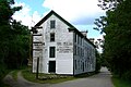
Countryside near Baltimore
Motto(s): 
By land and water we flourish
Northumberland locator map 2021.svg
Red pog.svg
Hamilton
Canada Southern Ontario location map 2.png
Red pog.svg
Hamilton
Coordinates: 44°03′N78°13′W / 44.050°N 78.217°W / 44.050; -78.217
Country Canada
Province Ontario
County Northumberland
Settled1791
Incorporated1850
Government
  TypeTownship
  MayorScott Jibb
  Federal riding Northumberland—Peterborough South
  Prov. riding Northumberland—Peterborough South
Area
[1]
  Land256.08 km2 (98.87 sq mi)
Population
 (2016) [1]
  Total10,942
  Density42.7/km2 (111/sq mi)
Time zone UTC-5 (EST)
  Summer (DST) UTC-4 (EDT)
Area code(s) 905, 289, 365, and 742
Website www.hamiltontownship.ca
Hamilton Township, Ontario
Map of Rice Lake and environs

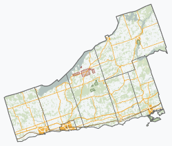
Hamilton Township is a rural township located in Northumberland County in central Ontario. It surrounds the Town of Cobourg.

Contents

The township was named after Henry Hamilton, Lieutenant-Governor of Quebec from 1782 to 1785.

Communities

Demographics

In the 2021 Census of Population conducted by Statistics Canada, Hamilton Township had a population of 11,059 living in 4,281 of its 4,685 total private dwellings, a change of 1.1% from its 2016 population of 10,942. With a land area of 256.03 km2 (98.85 sq mi), it had a population density of 43.2/km2 (111.9/sq mi) in 2021. [2]

Canada census – Hamilton Township community profile
2021 2016 2011
Population11,059 (+1.1% from 2016)10,942 (+2.2% from 2011)10,702 (-2.5% from 2006)
Land area256.03 km2 (98.85 sq mi)256.08 km2 (98.87 sq mi)256.12 km2 (98.89 sq mi)
Population density43.2/km2 (112/sq mi)42.7/km2 (111/sq mi)41.8/km2 (108/sq mi)
Median age49.6 (M: 49.2, F: 50.0)49.1 (M: 49.0, F: 49.2)
Private dwellings4,685 (total)  4,281 (occupied)4,677 (total) 4,377 (total) 
Median household income$106,000$88,124
References: 2021 [3] 2016 [4] 2011 [5] earlier [6] [7]
Hamilton Township population history
YearPop.±%
19919,616    
1996 10,140+5.4%
2001 10,785+6.4%
2006 10,972+1.7%
2011 10,702−2.5%
2016 10,942+2.2%
[8] [1]
1996 population would have been 9,982 using 2001 boundaries

Mother tongue: [9]

See also

Related Research Articles

<span class="mw-page-title-main">Adjala-Tosorontio</span> Township in Ontario, Canada

Adjala–Tosorontio is a township in south-central Ontario, Canada, in the County of Simcoe.

<span class="mw-page-title-main">Tweed, Ontario</span> Municipality in Ontario, Canada

Tweed is a municipality located in central-eastern Ontario, Canada, in Hastings County.

<span class="mw-page-title-main">Central Frontenac</span> Township in Ontario, Canada

Central Frontenac is a township in eastern Ontario, Canada in the County of Frontenac.

<span class="mw-page-title-main">Centre Hastings</span> Municipality in Ontario, Canada

The Municipality of Centre Hastings is a township in Eastern Ontario, Canada, in Hastings County. It was formed on January 1, 1998, through the amalgamation of Huntingdon Township with the Village of Madoc.

<span class="mw-page-title-main">Black River-Matheson</span> Township in Ontario, Canada

Black River-Matheson is a township in the Cochrane District of the Canadian province of Ontario. The municipality is astride the Black River, for which it is partly named. The Matheson railway station was serviced by the Northlander until 2012.

<span class="mw-page-title-main">South Frontenac</span> Township in Ontario, Canada

South Frontenac is a township in Frontenac County in eastern Ontario, Canada. It was amalgamated in 1998 from the former townships of Bedford, Loughborough, Portland, and Storrington.

<span class="mw-page-title-main">Brockton, Ontario</span> Municipality in Ontario, Canada

Brockton is a municipality in the Canadian province of Ontario, located in Bruce County. As of 2016, the population was 9,461.

<span class="mw-page-title-main">Minden Hills</span> Township in Ontario, Canada

Minden Hills is a township in and the county seat of Haliburton County, Ontario, Canada. It is an amalgam of the townships of Snowdon, Lutterworth, Anson, Hindon and Minden. It is usually referred to as Minden, after its largest community.

<span class="mw-page-title-main">Limerick, Ontario</span> Township in Ontario, Canada

Limerick is a small township in Hastings County, Ontario, Canada, near Limerick Lake. It is located 80 kilometres (50 mi) north of Belleville between Madoc and Bancroft and served by Ontario Highway 62 and Township Road 620. The Township is bordered by the Town of Bancroft, Township of Wollaston and the joined Townships of Tudor and Cashel. The township is heavily forested, as is the shoreline of the Limerick Lake, the main industry in the township being forestry and logging. The population of Limerick Township is approx. 300 full-year residents, and another 1000 seasonal residents.

<span class="mw-page-title-main">Alnwick/Haldimand</span> Township in Ontario, Canada

The Township of Alnwick/Haldimand is a township in central Ontario, Canada, in Northumberland County, situated between Lake Ontario and Rice Lake. It was formed in 2001 by the merger of Alnwick Township in the north and Haldimand Township in the south. Alderville First Nation is an autonomously governed First Nation contained within the township boundaries, in two non-contiguous sections along County Roads 45 and 18.

<span class="mw-page-title-main">Evanturel</span> Township in Ontario, Canada

Évanturel is a township in Timiskaming District, Ontario, Canada. It almost completely surrounds the town of Englehart. The main settlement in Évanturel is the community of Heaslip.

<span class="mw-page-title-main">Cramahe, Ontario</span> Township in Ontario, Canada

Cramahe is a rural township located in Northumberland County in southern Ontario, Canada. It is situated just off Ontario Highway 401 approximately 140 km East of Toronto. It was named for Hector Theophilus de Cramahé, who was Lieutenant-Governor of the Province of Quebec. The township's seat and largest town is Colborne.

<span class="mw-page-title-main">Billings, Ontario</span> Township in Ontario, Canada

Billings is a township in the Canadian province of Ontario, as well as the name of a community within that township.

<span class="mw-page-title-main">Stirling-Rawdon</span> Township in Ontario, Canada

Stirling-Rawdon is a township in the Canadian province of Ontario, located in Hastings County. It was formed on January 1, 1998, through the amalgamation of Rawdon Township with the Village of Stirling. Stirling was named the 2012 Kraft Hockeyville winner, after gaining more than 3.9 million votes.

<span class="mw-page-title-main">Front of Yonge</span> Township in Ontario, Canada

Front of Yonge is a township found in the United Counties of Leeds and Grenville in Ontario, Canada. It is the location of the Thousand Islands National Park and Brown's Bay Provincial Park, as well as a number of private campgrounds, the Jones Creek walking trail system, and the 1000 Islands Waterfront Trail’s walking/bike path which runs from just beyond the township’s eastern boundary to neighbouring towns. The predominance of the Canadian Shield produces scenic and diverse landscapes which include exposed rock formations and heavy tree cover, as well as wide fields and beaches.

<span class="mw-page-title-main">Gauthier, Ontario</span> Township municipality in Ontario, Canada

Gauthier is a township municipality in Timiskaming District the Northeastern Ontario, Canada. The township had a population of 138 in the Canada 2016 Census. Its main population centre is Dobie, located just north of Ontario Highway 66, 18.5 kilometres (11.5 mi) east of Kirkland Lake.

<span class="mw-page-title-main">Tudor and Cashel</span> Township in Ontario, Canada

Tudor and Cashel is a township in the Canadian province of Ontario, located in Hastings County.

<span class="mw-page-title-main">Algonquin Highlands</span> Township in Ontario, Canada

Algonquin Highlands is a township located in Haliburton County, Ontario, Canada. It has a population of 2,351. The northeastern section of the township is included in Algonquin Provincial Park.

<span class="mw-page-title-main">Faraday, Ontario</span> Township in Ontario, Canada

Faraday is a township in the Canadian province of Ontario, located within Hastings County adjacent to the town of Bancroft.

<span class="mw-page-title-main">Gordon/Barrie Island</span> Municipality in Ontario, Canada

The Municipality of Gordon/Barrie Island is a township in Manitoulin District in north central Ontario, Canada. It was formed on January 1, 2009, upon the amalgamation of the townships of Gordon and Barrie Island.

References

  1. 1 2 3 "Census Profile, 2016 Census: Hamilton, Township". Statistics Canada. 8 February 2017. Retrieved June 25, 2019.
  2. "Population and dwelling counts: Canada, provinces and territories, census divisions and census subdivisions (municipalities), Ontario". Statistics Canada. February 9, 2022. Retrieved April 2, 2022.
  3. "2021 Community Profiles". 2021 Canadian Census . Statistics Canada. February 4, 2022. Retrieved 2023-10-19.
  4. "2016 Community Profiles". 2016 Canadian Census . Statistics Canada. August 12, 2021. Retrieved 2019-06-25.
  5. "2011 Community Profiles". 2011 Canadian Census . Statistics Canada. March 21, 2019. Retrieved 2012-03-15.
  6. "2006 Community Profiles". 2006 Canadian Census . Statistics Canada. August 20, 2019.
  7. "2001 Community Profiles". 2001 Canadian Census . Statistics Canada. July 18, 2021.
  8. Statistics Canada: 1996, 2001, 2006, 2011 Census
  9. Statistics Canada 2006 Census - Hamilton community profile Retrieved 2016-03-27