Hartley, Kent

Last updated

Hartley
Hartley Church - geograph.org.uk - 326758.jpg
All Saints Church
Kent UK location map.svg
Red pog.svg
Hartley
Location within Kent
Population5,359 (2011 Census) [1]
OS grid reference TQ605675
Civil parish
  • Hartley
District
Shire county
Region
Country England
Sovereign state United Kingdom
Post town LONGFIELD
Postcode district DA3
Dialling code 01474
Police Kent
Fire Kent
Ambulance South East Coast
UK Parliament
List of places
UK
England
Kent
51°23′13″N0°18′13″E / 51.386812°N 0.303691°E / 51.386812; 0.303691 Coordinates: 51°23′13″N0°18′13″E / 51.386812°N 0.303691°E / 51.386812; 0.303691

Hartley is a village and civil parish in the Sevenoaks District of Kent, England. It is located 7 miles south west of Gravesend and the same distance south east of Dartford.

Contents

History

The village of Hartley is recorded as Erclei in the Domesday Book of 1086. [2] with a population of 15 families and 3 slaves. [3] The name Hartley means "place in the wood where the deer are". The parish church of All Saints dates from the early 12th century, although it probably replaced an earlier Anglo-Saxon building. [4]

On 28 January 1554, during Wyatt's Rebellion against Queen Mary, a rebel force of about 500 men led by Henry Isley clashed with a similar-sized loyal force led by Lord Abergavenny and Sir Robert Southwell, at Wrotham Hill. After a running battle over about four miles, the rebels made their last stand at Hartley Wood, where they were defeated. [5]

By 1872, there were 47 houses in Hartley with a population of 244. Some local farms specialised in hop growing. [6] A National School was built in the village in 1841; it was rebuilt in 1960 on a new site.

The opening nearby of Longfield railway station in 1872 began the evolution of the village from an agricultural to a commuter community. Just before World War I, two agricultural estates were purchased by a property developer and sold off in small plots for new houses and bungalows. Major housing developments at New Ash Green in the 1960s and Wellfield in the 1970s continued the trend. [7]

The parish was part of Axstane Hundred and later Dartford Rural District. It is part of the parliamentary constituency of Dartford. [8]

Places of worship

All Saints Church, the Anglican parish church, is Grade I-listed and dates from the 12th century. [9] [10] It is supplemented by the All Saints Church Centre in the centre of the village, which is used as a church hall and for worship. [11] St Francis de Sales' Roman Catholic church, a Grade II-listed building, is a 17th-century former barn with timber framing and a thatched roof. [10] [12] Hartley United Reformed Church (formerly Congregational) was registered for worship in 1936 [10] [13] but has closed and was put up for sale, [14] before being demolished and turned into housing.

Sports

Hartley Country Club cricket section were the Kent Cricket League Premier Champions in 2008, 2011-2013 and 2015. This is a league that is fought at an extremely high level against well known and respected clubs such as Bromley and Bexley. 2011 was a very successful year-the years accolades include-1st XI champions, 2nd XI champions, 5th XI champions and 20/20 champions.

The Pétanque section membership at Hartley Country Club currently numbers about ninety players, split equally between men and women. The playing standard varies from casual club play to International level, with the majority of players being of good average club standard.

Transport

Rail

Hartley is served by Longfield station with National Rail services to London Victoria via Bromley South, Ramsagate via Chatham and Dover Priory via Chatham & Canterbury East.

Buses

Hartley is served by Arriva Kent Thameside routes 423, 433 & 489. These connect it with Bluewater, Dartford & Gravesend.

See also

Related Research Articles

Borough of Dartford Borough & Non-metropolitan district in England

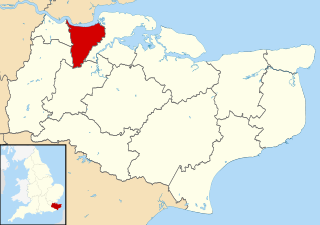
The Borough of Dartford is a local government district in the north-west of the county of Kent, England. Its council is based in the town of Dartford. It is part of the contiguous London urban area. It borders the borough of Gravesham to the east, Sevenoaks District to the south, the London Borough of Bexley to the west, and the Thurrock unitary authority in Essex to the north, across the River Thames. The borough was formed on 1 April 1974 by the merger of the Municipal Borough of Dartford, the Swanscombe Urban District, and part of the Dartford Rural District. According to the 2011 Census, its population was 97,365.

Otford Human settlement in England

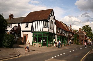
Otford is a village and civil parish in the Sevenoaks District of Kent, England. It lies on the River Darent, 3 miles (5 km) north of Sevenoaks. Otford's four churches are the Anglican Church of St Bartholomew in the village centre, the Otford Methodist Church, the Most Holy Trinity Roman Catholic Church, and the Otford Evangelical Church. By the village pond, also a roundabout, there are pubs, cafes and shops. The village has two schools, Otford Primary School and Russell House.

Gravesham Borough & Non-metropolitan district in England

Gravesham is a local government district with borough status in north-west Kent, England. Its administrative centre and largest town is Gravesend, which was known as Gravesham in ancient times.

Swanley Human settlement in England

Swanley is a town and civil parish in the Sevenoaks District of Kent, England. It is located approximately 15 miles (24 km) southeast of central London, adjacent to the Greater London boundary and within the M25 motorway periphery. The population at the 2011 census was 16,226. The local council is Swanley Town Council.

West Kingsdown Human settlement in England

West Kingsdown is a village and civil parish in the Sevenoaks district of Kent, England, on the A20 5 miles (8 km) southeast of Swanley, 5.5 miles (9 km) northeast of Sevenoaks and 22.5 miles (36.2 km) from London.

Longfield Human settlement in England

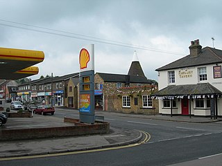
Longfield is a village in the Dartford, Kent, England. It is located 6 miles south east of Dartford and the same distance south-west of Gravesend.

The Chatham main line is a railway line in England that links London Victoria and Dover Priory / Ramsgate, travelling via Medway.

Longfield railway station station in north Kent, England

Longfield railway station is on the Chatham Main Line in England, serving the villages of Longfield, Hartley, and New Ash Green. It is 23 miles 30 chains (37.6 km) down the line from London Victoria and is situated between Farningham Road and Meopham.

Dartford (UK Parliament constituency) Parliamentary constituency in the United Kingdom, 1885 onwards

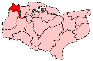
Dartford is a constituency represented in the House of Commons of the UK Parliament since 2010 by Gareth Johnson of the Conservative Party. The constituency is currently the longest-valid 'bellwether' constituency in the country as the party of the winning candidate has gone on to form the government in every General Election since 1964. Candidates for the largest two parties nationally have polled first and second since 1923 in Dartford.

Fawkham Junction

Fawkham Junction is a railway junction that currently connects High Speed 1 with the Kent Rail Network.

Farningham Human settlement in England

Farningham is a village and civil parish in the Sevenoaks District of Kent, England. It is located 3 miles (5 km) south-east of Swanley. It has a population of 1,314.

Fawkham Human settlement in England

Fawkham is a village and civil parish in the Sevenoaks District of Kent, England. Fawkham is defined as a hamlet by Sevenoaks District Council, with a population of 429. Fawkham is a low density, linear settlement along the bottom of a dry chalk valley some three miles in length, with secondary lanes intersecting. There is no discernible village centre, although clusters of buildings occur near the Church/junction with Castle Hill, and around the village green and public house at the junction with Fawkham Green Road. There are around 220 houses.

Dartford Rural District was a rural district with an area of 34,037 acres (138 km2) in the county of Kent, England. In 1971 it had a population of 64,561 and an electorate of 43,911. At dissolution it was the most populous rural district council in Kent, but had once been larger, having lost territory when Crayford Urban District was created in 1920, and Swanscombe Urban District in 1926.

New Barn Human settlement in England

New Barn is a compact residential area surrounded by open fields which lies four miles southwest of Gravesend in Kent, England. It is in the local government district of Dartford. The villages of New Barn and Longfield are within and give their names to the civil parish of Longfield and New Barn. New Barn is larger in population than Longfield, although has little in the way of services, being a recent development and purely residential in nature

Sutton-at-Hone Human settlement in England

Sutton-at-Hone is a village in the civil parish of Sutton-at-Hone and Hawley in the Borough of Dartford in Kent, England. It is located 3.5 miles south of Dartford & 3.6 miles north east of Swanley.

Ridley, Kent Human settlement in England

Ridley is a place and former civil parish in the county of Kent, England. It lies between Sevenoaks and Chatham, and is within the Sevenoaks local government district. It is part of the Ash-cum-Ridley civil parish.

Axstane Hundred human settlement in United Kingdom

Axstane was a hundred in the county of Kent, England. The Hundred of Axstane lay south-east of Dartford and Wilmington Hundred. It is called Achestan in Domesday Book, but by the reign of Edward I it was called Axstane.

References

  1. "Civil Parish population 2011". Neighbourhood Statistics. Office for National Statistics. Retrieved 19 September 2016.
  2. "The Domesday Book Online - Kent F-N". domesdaybook.co.uk.
  3. Chris Mavricos, SevenSpark. "Hartley Kent: History Index". hartley-kent.org.uk.
  4. "All Saints Church". fawkhamandhartley.org.uk.
  5. Taylor, James D. (2006). The Shadow of the White Rose: Edward Courtenay, Earl of Devon, 1526-1556. Algora Publishing. pp. 89–90. ISBN   978-0-87586-474-7.
  6. "History of Hartley, in Sevenoaks and Kent - Map and description". visionofbritain.org.uk.
  7. Hartley Parish Council - History
  8. "Who should YOU vote for at the General Election?". whoshallivotefor.com. Retrieved 29 November 2016.
  9. Historic England. "Details from listed building database (1238242)". National Heritage List for England . Retrieved 22 November 2012.
  10. 1 2 3 "Hartley Churches". Peter Mayer (hartley-kent.org.uk). 2012. Archived from the original on 11 November 2012. Retrieved 22 November 2012.
  11. "All Saints Church Centre, Hartley. Parish of Fawkham and Hartley, Hartley". A Church Near You website. Archbishops' Council. 2010. Archived from the original on 24 January 2013. Retrieved 22 November 2012.
  12. Historic England. "Details from listed building database (1274097)". National Heritage List for England . Retrieved 22 November 2012.
  13. "No. 34292". The London Gazette . 9 June 1936. p. 3705.
  14. "Hartley United Reformed Church, Ash Road, Hartley, Longfield, Kent DA3 8EL" (PDF). Caxtons Chartered Surveyors. October 2011. Archived from the original (PDF) on 11 November 2012. Retrieved 22 November 2012.