
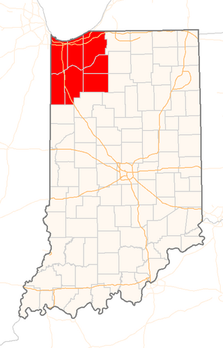
Lake County is a county located in the U.S. state of Indiana. In 2020, its population was 498,700, making it Indiana's second-most populous county. The county seat is Crown Point. The county is part of Northwest Indiana and the Chicago metropolitan area, and contains a mix of urban, suburban and rural areas. It is bordered on the north by Lake Michigan and contains a portion of the Indiana Dunes. It includes Marktown, Clayton Mark's planned worker community in East Chicago.
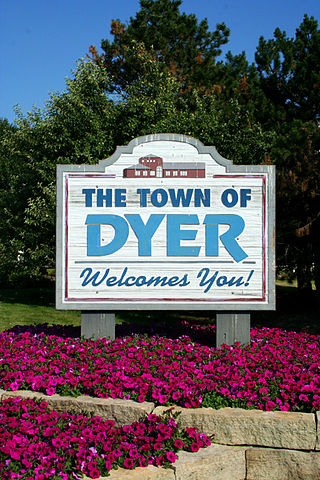
Dyer is a town in St. John Township, Lake County, Indiana, United States. The population was 16,517 at the 2020 census. It is a southeastern suburb of Chicago.

Griffith is a town in North and St. John townships in Lake County, Indiana, United States. It is a part of the Chicago metropolitan area. The population was 16,420 in 2020. The town's population is currently declining at a rate of 0.69% annually. Griffith is the town with the 11th largest population and 17th largest town by area in the State of Indiana.

Schererville is a town in St. John Township, Lake County, Indiana, United States. The population was 29,646 at the 2020 census It is a suburb of Chicago, located 30 miles south of the city.

The Calumet River is a system of heavily industrialized rivers and canals in the region between the south side of Chicago, Illinois, and the city of Gary, Indiana. Historically, the Little Calumet River and the Grand Calumet River were one, the former flowing west from Indiana into Illinois, then turning back east to its mouth at Lake Michigan at Marquette Park in Gary. Now the system is part of the Chicago Area Waterway System and through the use of locks flows away from Lake Michigan to the Cal-Sag Channel.

Indiana Dunes National Park is a United States national park located in northwestern Indiana managed by the National Park Service. It was authorized by Congress in 1966 as the Indiana Dunes National Lakeshore and was redesignated as the nation's 61st national park on February 15, 2019. The park runs for about 20 miles (32 km) along the southern shore of Lake Michigan and covers 15,349 acres (6,212 ha). Along the lakefront, the eastern area is roughly the lake shore south to U.S. 12 or U.S. 20 between Michigan City, Indiana, on the east and the Cleveland-Cliffs steel plant on the west. This area's conservation scheme is enhanced by the older Indiana Dunes State Park. To the west of the steel plant lies West Beach and a small extension south of the steel mill continues west along Salt Creek to Indiana 249. The western area is roughly the shoreline south to U.S. 12 between the Burns Ditch west to Broadway in downtown Gary, Indiana. In addition, there are several outlying areas, including Pinhook Bog, in LaPorte County to the east; the Heron Rookery in Porter County, the center of the park; and the Calumet Prairie State Nature Preserve and the Hobart Prairie Grove, both in Lake County, the western end of the park.

The Elgin, Joliet and Eastern Railway was a Class II railroad, making a roughly circular path between Waukegan, Illinois and Gary, Indiana. The railroad served as a link between Class I railroads traveling to and from Chicago, although it operated almost entirely within the city's suburbs, only entering Chicago where it served the U.S. Steel South Works on the shores of Lake Michigan. Nicknames for the railroad included "The J" and "The Chicago Outer Belt Line". At the end of 1970, the EJ&E operated 164 miles of track and carried 848 million ton-miles of revenue freight in that year alone.
The Calumet Region is the geographic area drained by the Grand Calumet River and the Little Calumet River of northeastern Illinois and northwestern Indiana in the United States. It is part of the Great Lakes Basin, which eventually reaches the Atlantic Ocean. It is a sub-region of the greater Northwest Indiana region and the even larger Great Lakes region.
Northwest Indiana, nicknamed The Region after the Calumet Region, is an unofficial region of northern Indiana, United States that is located at the northwestern corner of the state. Though there is no official definition of the region, it is based on the Gary, Indiana Metropolitan Division, which comprises Jasper, Lake, Porter and Newton counties in Indiana, and the Michigan City-La Porte, IN Metropolitan Statistic Area, which comprises LaPorte, with unofficial definitions also including Starke and Pulaski counties. This region neighbors Lake Michigan and parts of it are in the Chicago metropolitan area. According to the 2020 Census, the largest definition of Northwest Indiana has a population of 866,965 and is the state's second largest urban area after the Indianapolis Metropolitan Area. It is also the home of the Indiana Dunes, parts of which have been preserved through conservation efforts. The town of Ogden Dunes houses the Hour Glass, a museum showcasing the ecological and conservation efforts of O. D. Frank.

U.S. Route 12 (US 12) is a part of the United States Numbered Highway System that runs from Aberdeen, Washington, to Detroit, Michigan. In the U.S. state of Indiana, it is part of the state road system. US 12 enters the state concurrent with US 20 and US 41 in Whiting. The 46.258 miles (74.445 km) of US 12 that lie within Indiana serve as a major conduit. Some of the highway is listed on the National Highway System (NHS). Various sections are rural two-lane highway, urbanized four-lane undivided highway, and one-way streets. The easternmost community along the highway is Michiana Shores at the Michigan state line.

Hammond–Whiting station is an Amtrak intercity train station in Hammond, Indiana. The station is along the former Pennsylvania Railroad Fort Wayne Line, now owned by Norfolk Southern Railway. North of the station lies the former Baltimore and Ohio and Elgin, Joliet and Eastern Railroad tracks. The station building and parking lot lies on the former New York Central Railroad mainline. Hammond–Whiting opened on September 11, 1982. Until the early 2000s, it was served by all Amtrak service that ran east from Chicago; today, it is only served by two daily Wolverine round trips.
The Aurora, Elgin & Fox River Electric (AE&FRE), was an interurban railroad that operated freight and passenger service on its line paralleling the Fox River. It served the communities of Carpentersville, Dundee, Elgin, South Elgin, St. Charles, Geneva, Batavia, North Aurora, Aurora, Montgomery, and Yorkville in Illinois. It also operated local streetcar lines in both Aurora and Elgin.

The Valparaiso Moraine is a recessional moraine that forms an immense U around the southern Lake Michigan basin in North America. It is a band of hilly terrain composed of glacial till and sand. The Valparaiso Moraine defines part of the continental divide known as the Saint Lawrence River Divide, bounding the Great Lakes Basin. It begins near the border of Wisconsin and Illinois and extends south through Lake, McHenry, Cook, DuPage and Will counties in Illinois, and then turns southeast, going through northwestern Indiana. From this point, the moraine curves northeast through Lake, Porter, and LaPorte counties of Indiana into Michigan. It continues into Michigan as far as Montcalm County.
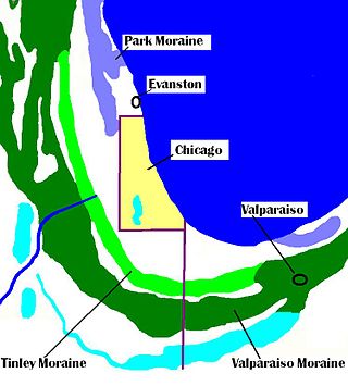
The Tinley Moraine is a moraine around the Lake Michigan basin in North America. It was formed during the Wisconsin Glaciation and is younger than the higher and wider terminal moraine called the Valparaiso Moraine, which is located farther from the lake than the Tinley Moraine. Compared to the Valparaiso Moraine, the Tinley Moraine is much narrower and occupies a similar swath, about 6 miles (10 km) closer to Lake Michigan, and passes through the communities of Flossmoor, Western Springs, and Arlington Heights. The moraine was named after the village of Tinley Park, a village southwest of Chicago that lies on the moraine.

The Calumet Shoreline is an ancient shoreline of Lake Michigan located in the Lake Michigan Basin. It can be clearly seen as a sand ridge along Ridge Road south of Chicago. Closer to the lake from the Calumet Shoreline, there are the Tolleston shorelines and farther from the lake are the Glenwood Shoreline, the Tinley Moraine, and the Valparaiso Moraine. The shoreline is named after the Calumet Region of Northern Indiana.

The Glenwood Shoreline is an ancient shoreline of the precursor to Lake Michigan, Lake Chicago. It is named after the town of Glenwood, Illinois. The shoreline was formed when the lake was higher during the last ice age, while ice blocked the Straits of Mackinac. After the straits were freed, the lake receded and left behind a sand ridge at an elevation of about 640 feet (200 m) where the shore resided. This ridge can be seen clearly in Glenwood, Illinois, Dyer, Indiana, and Schererville, Indiana, all south of Chicago.

Hobart, also known as The Pennsy Depot, is a disused train station in Hobart, Indiana. It was built in 1911 and listed on the National Register of Historic Places in 1984 as the Pennsylvania Railroad Station.
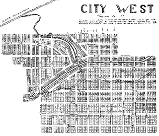
City West was a village in Porter County, Indiana, US, located on the shore of Lake Michigan approximately 10 miles west of Michigan City, Indiana. It was situated near the mouth of Fort Creek, now known as Dunes Creek, which empties into Lake Michigan near the Indiana Dunes State Park swimming beach. It was located near the former site of Petit Fort.

