Hartshorne, Derbyshire

Last updated

Hartshorne
Hartshorne church.jpg
St Peter's church
Derbyshire UK location map.svg
Red pog.svg
Hartshorne
Location within Derbyshire
Population3,888 (2011)
OS grid reference SK320213
District
Shire county
Region
Country England
Sovereign state United Kingdom
Post town Swadlincote
Postcode district DE11
Police Derbyshire
Fire Derbyshire
Ambulance East Midlands
List of places
UK
England
Derbyshire
52°47′20″N1°31′34″W / 52.789°N 1.526°W / 52.789; -1.526

Hartshorne is a village and civil parish in the English county of Derbyshire. The population of the civil parish at the 2011 census was 3,888. [1] It is north of the town of Swadlincote.

Contents

The name is pronounced "Harts-horn"; the sh is not a digraph, as this is a compound.

Etymology

The name of the village is first attested in the Domesday Book of 1086, where it appears in the spelling Heorteshorne. This comes from the Old English word heorot ('hart, adult male red deer') in the genitive case, compounded with the word horn ('horn'), and once meant 'hart's antler'. It appears that the name originally denoted not the village itself but the neighbouring hill to the south-east of the village, now called Horn Hill, which was thought to resemble a stag's antler. [2]

History

Hartshorne was mentioned in the Domesday book as belonging to Henry de Ferrers [3] and being worth ten shillings. [4] It passed to the Ireland family in the 14th century, and subsequently to the family of the Foljambe baronets.

The Rector of Hartshorne, William Dethick, founded a free school for local children in 1626.

In 1800, the owner of the Manor, William Bailey Cant, left it to the lawyer Thomas Erskine, in recognition of his role in the case of John Horne Tooke. [5]

Amenities

Local pubs include the Admiral Rodney, named after the 1st Baron Rodney (1719–1792); the Mill Wheel (with an 18th-century mill wheel measuring 20 feet (6.1 m) in diameter); the Bulls Head; and the Greyhound. "he Chesterfield Arms was demolished in September 2009. The Snooty Fox (formerly the Dominoes) was demolished in 2009. The New Inn closed in the 1960s and was then used as a hairdressing salon before being demolished in 1975 to make a car park extension for the Admiral Rodney.

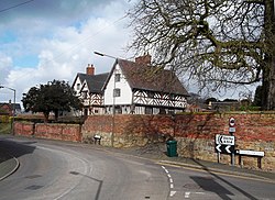
The Old Manor House in the northern part of the village is a Grade II* listed 17th-century timbered building on Main Street. [6] It was built for one John Benskin in 1629 according to parish rate records. [7] Situated south west of St Peter's Church in the southern part of the village, it is distinct from The Manor House (also known as the Old Hall) in the northern part of the village. [8] [9]

Transport

The local bus service is the No.2 maintained by Arriva Midlands between Derby and Swadlincote via Melbourne, this was previously a Trent route 168 & Arriva route No.69.

Notable residents

See also

Related Research Articles

<span class="mw-page-title-main">Bretby</span> Human settlement in England

<span class="mw-page-title-main">South Derbyshire</span> Non-metropolitan district in England

South Derbyshire is a local government district in Derbyshire, England. The council is based in the town of Swadlincote. The district also contains numerous villages and surrounding rural areas. About a third of the National Forest lies within the district.

<span class="mw-page-title-main">Normanton, Derby</span> Human settlement in England

Normanton is an inner city suburb and ward of the city of Derby in Derbyshire, England, situated approximately 2 miles (3.2 km) south of the city centre. Neighbouring suburbs include Littleover, Pear Tree, Rose Hill and Sunny Hill. The original village of Normanton-by-Derby, which now forms the southern part of the suburb, dates back to the medieval period. As the Normanton area became rapidly urbanised in the 19th century, the New Normanton area to the north was developed for housing, linking the old village to Derby, into which it was eventually absorbed. The area is characterised by high density late 19th century terraced housing in New Normanton and mid-20th century housing estates elsewhere, and has the most ethnically diverse population in Derby. The Normanton ward had a population of 17,071 in 2011.

<span class="mw-page-title-main">Markeaton</span> Human settlement in England

Markeaton is a suburban village and former civil parish within Derby in the ceremonial county of Derbyshire, England. It is in the Mackworth Ward of Derby City Council.

<span class="mw-page-title-main">Swadlincote</span> Town in South Derbyshire district, Derbyshire, England

Swadlincote is a former mining town in the district of South Derbyshire, England, lying within The National Forest area. It borders the counties of Leicestershire and Staffordshire, 5 miles (8 km) south-east of Burton upon Trent and north-west of Ashby-de-la-Zouch, 24 miles (39 km) north-east of Birmingham and 12 miles (19 km) south-west of Derby. It also covers Newhall, Oversetts, Midway and the suburban villages of Church Gresley and Woodville, with the sub-district of Goseley. It has a population of some 36,000. Castle Gresley is 2 miles (3 km) to the south-west and Albert Village 1.5 miles (2 km) to the south.

<span class="mw-page-title-main">Aston-on-Trent</span> Human settlement in England

Aston-on-Trent is a village and civil parish in the South Derbyshire district, in the county of Derbyshire, England. The parish had a population of 1,682 at the 2011 Census. It is adjacent to Weston-on-Trent and near Chellaston, very close to the border with Leicestershire.

<span class="mw-page-title-main">Willington, Derbyshire</span> Human settlement in England

Willington is a village and civil parish in the South Derbyshire district of Derbyshire, England. The 2001 Census recorded a parish population of 2,604, increasing to 2,864 at the 2011 Census.

<span class="mw-page-title-main">Doveridge</span> Human settlement in England

Doveridge is a village and civil parish in Derbyshire, United Kingdom, near the border with Staffordshire and about 2 km (1.2 mi) east of Uttoxeter. Its name may come from its having a bridge over the river Dove, a tributary of the River Trent. The civil parish population as taken at the 2011 Census was 1,622.

<span class="mw-page-title-main">Melbourne, Derbyshire</span> Human settlement in England

Melbourne is a market town and civil parish in South Derbyshire, England. It was home to Thomas Cook, and has a street named after him. It is 8 miles (13 km) south of Derby and 2 miles (3 km) from the River Trent. The population of the civil parish at the 2021 Census was 5,264.

<span class="mw-page-title-main">Kedleston</span> Human settlement in England

Kedleston is a village and civil parish in the Amber Valley district of Derbyshire, approximately 4 miles (6.4 km) north-west of Derby. Nearby places include Quarndon, Weston Underwood, Mugginton and Kirk Langley. The population at the 2011 Census was less than 100. Details are included in the civil parish of Mackworth, Amber Valley.

<span class="mw-page-title-main">Temple Normanton</span> Village in Derbyshire, England

Temple Normanton is a village and a civil parish in the North East Derbyshire district in Derbyshire, England. The population of the civil parish at the 2011 census was 490.

<span class="mw-page-title-main">North Wingfield</span> Human settlement in England

North Wingfield is a large village and civil parish in the North East Derbyshire district in the county of Derbyshire, England. Located approximately 4½ miles south-east of Chesterfield, and 1 mile north-east of Clay Cross. The population of the civil parish as of the 2011 census was 6,505. The A6175 road from the M1 motorway to the A61 road runs through the village.

<span class="mw-page-title-main">Morley, Derbyshire</span> Human settlement in England

Morley is a village and civil parish within the Borough of Erewash in Derbyshire, England.

<span class="mw-page-title-main">Brimington</span> Human settlement in England

Brimington is a large village and civil parish in the Borough of Chesterfield in Derbyshire, England. The population of the parish taken at the 2011 census was 8,788. The town of Staveley is to the east, and Hollingwood is nearby. The parish includes Brimington Common along the Calow Road, and New Brimington, a late 19th-century extension towards the Staveley Iron Works.

<span class="mw-page-title-main">Church Gresley</span> Village and former civil parish in Derbyshire

Church Gresley is a large village and former civil parish in the South Derbyshire district of Derbyshire, England. The village is situated between Castle Gresley and the town of Swadlincote, with which it is contiguous. By the time of the 2011 Census the village was a ward of Swadlincote, of which it is now effectively a suburb, and the population of Church Gresley ward was 6,881. The village forms part of the border with Leicestershire to the southeast. Nearby villages include Albert Village, Linton and Overseal.

<span class="mw-page-title-main">Foremark</span> Human settlement in England

Foremark is a hamlet and civil parish in the South Derbyshire district of Derbyshire, England. It contains Foremarke Hall, a medieval manor house which now houses Repton Preparatory School; and part of Foremark Reservoir.

<span class="mw-page-title-main">Linton, Derbyshire</span> Human settlement in England

Linton is a settlement and civil parish in South Derbyshire, England, 5 miles south east of Burton-on-Trent. The population of the civil parish taken at the 2011 Census was 2,303.

<span class="mw-page-title-main">Smisby</span> Human settlement in England

Smisby is an ancient manor, civil parish and small village in South Derbyshire, England. It is 4 miles (6.4 km) from Melbourne and near the Leicestershire border and the town of Ashby-de-la-Zouch. The village including the outlying farms and houses has a population just over 200 that occupies some 110 properties. The population at the 2011 Census had increased to 260.

<span class="mw-page-title-main">Boundary, Derbyshire</span> Human settlement in England

Boundary is a large hamlet and as The Boundary a former civil parish, in South Derbyshire situated between the towns of Swadlincote and Ashby-de-la-Zouch on the A511 route. It is west of the village of Smisby and forms part of the county border with Leicestershire, hence its name. Residences on the north side of the A511 lie in Derbyshire and those on the south side lie within Leicestershire. The hamlet now falls within the civil parishes of Smisby, Derbyshire and Ashby-de-la-Zouch, Leicestershire. In 1931 the parish had a population of 87.

The Hundreds of Derbyshire were the geographic divisions of the historic county of Derbyshire for administrative, military and judicial purposes. They were established in Derbyshire some time before the Norman conquest. In the Domesday Survey of 1086 AD the hundreds were called wapentakes. By 1273 the county was divided into 8 hundreds with some later combined, becoming 6 hundreds over the following centuries. The Local Government Act 1894 replaced hundreds with districts. Derbyshire is now divided into 8 administrative boroughs within the Derbyshire County Council area.

References

  1. "Civil Parish population 2011". Neighbourhood Statistics. Office for National Statistics. Retrieved 25 March 2016.
  2. The Cambridge Dictionary of English Place-Names, Based on the Collections of the English Place-Name Society, ed. by Victor Watts (Cambridge: Cambridge University Press, 2004), s.v. Hartshorne.
  3. Henry was given a large number of manors in Derbyshire including Doveridge, Linton, Pilsbury and Cowley.
  4. Domesday Book: A Complete Translation. London: Penguin. 2003. p. 745. ISBN   0-14-143994-7.
  5. "Parishes: Kirk-Hallam – Hault-Hucknall". Magna Britannia. London: T Cadell and W Davies. 1817. pp. 172–192. Retrieved 19 August 2023 via British History Online.
  6. "Hartshorne Circular Walk" (PDF). South Derbyshire District Council. Retrieved 19 August 2023.
  7. Williams 2010.
  8. Bulmer 1895, p. 754.
  9. Cameron 1876, p. 57.

Bibliography