Harua

Last updated

Harua
Village
Nickname: 
Haroa
West Bengal location map.svg
Red pog.svg
Harua
Location in West Bengal, India
India location map.svg
Red pog.svg
Harua
Harua (India)
Coordinates: 24°31′33″N87°59′23″E / 24.5257°N 87.9898°E / 24.5257; 87.9898
CountryFlag of India.svg  India
State West Bengal
District Murshidabad
Population
 (2011)
  Total9,012
Languages
  Official Bengali, English
Time zone UTC+5:30 (IST)
PIN
731221
ISO 3166 code IN-WB
Lok Sabha constituency Jangipur
Vidhan Sabha constituency Suti.
Website murshidabad.nic.in

Harua is a village and gram panchayat in the Suti I CD block in the Jangipur subdivision of Murshidabad district in the state of West Bengal, India. [1]

Contents

Geography

Harua
Invisible Square.svg
Mapscaleline.svg
5km
3miles
B
A
N
G
L
A
D
E
S
H
Kherur Mosque
H
Invisible Square.svg
Bhagirathi River
Bansloi River
Farakka Feeder Canal
Padma River
Rajnagar
R
Invisible Square.svg
Nurpur
R
Invisible Square.svg
Sagardighi
R
Invisible Square.svg
Sadikpur
R
Invisible Square.svg
Raghunathganj
R
Invisible Square.svg
Morgram
R
Invisible Square.svg
Manigram
R
Invisible Square.svg
Harua
R
Bansabati
R
Invisible Square.svg
Ahiran
R
Invisible Square.svg
Jangipur
M
Invisible Square.svg
Sagardighi TPS
FV
Invisible Square.svg
AMU: Murshidabad Centre
F
Invisible Square.svg
Bara Jumla
CT
Invisible Square.svg
Krishna Sali
CT
Invisible Square.svg
Teghari
CT
Invisible Square.svg
Donalia
CT
Invisible Square.svg
Khodarampur
CT
Invisible Square.svg
Osmanpur
CT
Invisible Square.svg
Jot Kamal
CT
Invisible Square.svg
Mithipur
CT
Invisible Square.svg
Giria
CT
Invisible Square.svg
Mirzapur
CT
Invisible Square.svg
Ramnagar
CT
Invisible Square.svg
Dafarpur
CT
Invisible Square.svg
Charka
CT
Invisible Square.svg
Srikantabati
CT
Invisible Square.svg
Ghorsala
CT
Invisible Square.svg
Nayabahadurpur
CT
Invisible Square.svg
Madna
CT
Invisible Square.svg
Fatellapur
CT
Invisible Square.svg
Cities, towns and locations in the southern portion of Jangipur subdivision, Murshidabad district (including Suti I, Raghunathganj I, Raghunathganj II, and Sagardighi CD blocks)
M: municipal town, CT: census town, R: rural / urban centre, F: Facility
Abbreviation: TPS: Thermal Power Station, AMU: Aligarh Muslim University
Owing to space constraints in the small map, the actual locations in a larger map may vary slightly.

Location

Harua is located at 24°31′33″N87°59′23″E / 24.5257°N 87.9898°E / 24.5257; 87.9898 .

Area overview

Jangipur subdivision is crowded with 52 census towns. The subdivision is located in the Rarh region that is spread over from adjoining Santhal Pargana division of Jharkhand. The land is slightly higher in altitude than the surrounding plains and is gently undulating. [2] [3] The river Ganges, along with its distributaries, is prominent nearby. At the head of the subdivision is the 2,245 m long Farakka Barrage, one of the largest projects of its kind in the country. [4] Murshidabad district shares with Bangladesh a porous international border which is notoriously crime prone. [5] The subdivision has two large power plants—the 2,100 MW Farakka Super Thermal Power Station and the 1,600 MW Sagardighi Thermal Power Station. [6] [7] According to a 2016 report, there are around 1,000,000 (1 million / ten lakh) workers engaged in the beedi industry in Jangipur subdivision. 90% are home-based and 70% of the home-based workers are women. [8] [9] [10] As of 2013, an estimated 2.4 million people reside along the banks of the Ganges alone in Murshidabad district. Severe erosion occurs along the banks. [11]

Note: The two maps present some of the notable locations in the subdivision. All places marked in the maps are linked in the larger full screen maps.

Demographics

According to the 2011 census of India, Harua had a total population of 9,012, of which 4,613 (51%) were males and 4,399 (49%) were females. The population in the age range 0–6 years was 1,664. The total number of literate people in Harua was 3,382 (46.03% of the population over 6 years old). [12]

Economy

In this area, United Bank of India has Harua branch.

Education

Related Research Articles

Fatullapur is a census town in the Suti I CD block in the Jangipur subdivision of the Murshidabad district in the state of West Bengal, India.

<span class="mw-page-title-main">Jangipur subdivision</span> Subdivision in West Bengal, India

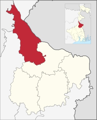
Jangipur subdivision is an administrative subdivision of Murshidabad district in the state of West Bengal, India.

Morgram is a village and gram panchayat in the Sagardighi CD block in the Jangipur subdivision of Murshidabad district in the Indian state of West Bengal.

Raghunathganj is a town, not identified in 2011 census as a separate place, with a police station and post office, in the Raghunathganj I CD block in the Jangipur subdivision of Murshidabad in the state of West Bengal, India.

Suti is a town, with a police station, not identified in 2011 census as a separate place, in the Suti II CD block in the Jangipur subdivision of Murshidabad district in the state of West Bengal, India.

<span class="mw-page-title-main">Ahiran</span> Village/City in West Bengal, India

Ahiran is a village in the Suti I CD block in the Jangipur subdivision of Murshidabad district in the state of West Bengal, India. It serves as the Headquarters of the Suti I administrative division.

Bansabati is a village and a gram panchayat in the Suti I CD block in the Jangipur subdivision of Murshidabad district in the state of West Bengal, India.

Sadikpur is a village and a gram panchayat in the Suti I CD block in the Jangipur subdivision of Murshidabad district in the state of West Bengal, India.

Nurpur is a village and gram panchayat in Murshidabad district in the state of West Bengal, India. Nurpur Gram panchayats in Suti I community development block.

Nayabahadurpur is a census town in the Suti I CD block in the Jangipur subdivision of the Murshidabad district in the state of West Bengal, India.

Madna is a census town in the Suti I CD block in the Jangipur subdivision of the Murshidabad district in the state of West Bengal, India.

Ramakantapur is a census town in the Suti I CD block in the Jangipur subdivision of the Murshidabad district in the state of West Bengal, India.

Nabarun is a neighbourhood of Farakka, not identified in 2011 census, with a post office, in Farakka CD Block in Jangipur subdivision of Murshidabad district in the state of West Bengal, India.

Mahesail is a village and a gram panchayat in the Suti II CD block in the Jangipur subdivision of Murshidabad district in the state of West Bengal, India.

Manigram is a village and a gram panchayat in the Sagardighi CD block in the Jangipur subdivision of Murshidabad district in the state of West Bengal, India.

Mahendrapur is a census town in the Suti II CD block in the Jangipur subdivision of the Murshidabad district in the state of West Bengal, India.

Ichhlampur is a census town in the Suti II CD block in the Jangipur subdivision of the Murshidabad district in the state of West Bengal, India.

Kakramari is a census town in the Suti II CD block in the Jangipur subdivision of the Murshidabad district in the state of West Bengal, India.

Khidirpur is a census town in the Suti II CD block in the Jangipur subdivision of the Murshidabad district in the state of West Bengal, India.

Rajnagar is a village in the Raghunathganj I CD block in the Jangipur subdivision of Murshidabad district in the state of West Bengal, India.

References

  1. Harua Population - Murshidabad, West Bengal. Census 2011. Retrieved 22 December 2015.
  2. "District Census Handbook: Murshidabad, Series 20 Part XII A" (PDF). Physiography, Page 13. Directorate of Census Operations, West Bengal, 2011. Retrieved 24 July 2017.
  3. "Murshidabad". Geography. Murshidabad district authorities. Retrieved 24 July 2017.
  4. "Farakka Barrage Project". FBP. Retrieved 12 September 2017.
  5. "Child labour, illness & lost childhoods, India's tobacco industry". Edge of Humanity Magazine, 27 December 2020. Retrieved 13 July 2021.
  6. "Power Generation". Farakka. NTPC. Retrieved 7 August 2016.
  7. "The West Bengal Power Development Corporation Limited". Sagardighi Thermal Power Project. WBPDCL. Archived from the original on 23 August 2017. Retrieved 15 August 2017.
  8. Kar, Sunirmal. "Child workers in household industry: a study of beedi industry in Murshidabad district of West Bengal" (PDF). Viswa Bharati University thesis, page 5. Shodhganga. Retrieved 28 August 2017.
  9. "The 'Poor man's cigarette'". Gurvinder Singh. The Statesman, 22 January 2017. Retrieved 28 August 2017.
  10. "Beedi workers of Jangipur hold key". Indrani Dutta. The Hindu, 1 May 2009. Retrieved 28 August 2017.
  11. "Types and sources of floods in Murshidabad, West Bengal" (PDF). Swati Mollah. Indian Journal of Applied Research, February 2013. Archived from the original (PDF) on 20 August 2017. Retrieved 5 September 2017.
  12. "C.D. Block Wise Primary Census Abstract Data(PCA)". West Bengal – District-wise CD Blocks. Registrar General and Census Commissioner, India. Retrieved 23 June 2018.