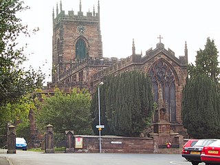
Penkridge is a large village and civil parish in South Staffordshire District in Staffordshire, England. It is to the south of Stafford, north of Wolverhampton, west of Cannock, east of Telford and south-east of Newport.

Gnosall is a village and civil parish in the Borough of Stafford, Staffordshire, England, with a population of 4,736 across 2,048 households. It lies on the A518, approximately halfway between the towns of Newport and the county town of Staffordshire, Stafford. Gnosall Heath lies immediately south-west of the main village, joined by Station Road and separated by Doley Brook. Other nearby villages include Woodseaves, Knightley, Cowley, Ranton, Church Eaton, Bromstead Heath, Moreton, and Haughton.

Penn is an area which is divided between the City of Wolverhampton and South Staffordshire district. The population of the Wolverhampton Ward taken at the 2011 census was 12,718. Originally, it was a village in the historic county of Staffordshire. There is considerable confusion about exactly which areas fall within Penn. In 19th century censuses, Merry Hill, Bradmore are understood to form part of Penn, although these areas are generally understood to be separate today. However, there has never been any doubt that the two historic settlements of Upper and Lower Penn form the core of the area.

Seisdon is a rural village in the parish of Trysull and Seisdon, Staffordshire approximately six miles west of Wolverhampton and the name of one of the five hundreds of Staffordshire. The population recorded at the 2011 census does not distinguish this hamlet from the rest of the parish, which had a population of 1,150.

Codsall is a large village in the South Staffordshire district of Staffordshire, England. It is situated 5 miles northwest of Wolverhampton and 13 miles east-southeast of Telford. It forms part of the boundary of the Staffordshire-West Midlands County border, along with Perton, the village is almost contiguous with Wolverhampton with very small amounts of greenbelt still separating the two settlements.

Wombourne is a village and civil parish located in the district of South Staffordshire, in the county of Staffordshire, England. It is 4 miles (6 km) south-west of Wolverhampton and just outside the county and conurbation of the West Midlands.

Shenstone is a village and civil parish in The Lichfield District, Staffordshire, England, located between Lichfield and Sutton Coldfield. The parish also contains the village of Stonnall.

Brewood is an ancient market town in the civil parish of Brewood and Coven, in the South Staffordshire district, in the county of Staffordshire, England. Located around grid reference SJ883088, Brewood lies near the River Penk, eight miles north of Wolverhampton city centre and eleven miles south of the county town of Stafford. A few miles to the west of Brewood is the border with the county of Shropshire.
Featherstone is a town in the district of South Staffordshire, England, near to the border with Wolverhampton.

Huntington is a civil parish and former mining village in Staffordshire, on the outskirts of Cannock Chase. It lies on the A34 road just north of Cannock and is surrounded by woodland. The village had an estimated population of 3,720 in 2004, increasing to 4,536 at the 2011 Census. The population in Huntington on the 2021 census was 4,715, a 3.94% increase from the decade before.

Tixall is a small village and civil parish in the Stafford district, in the English county of Staffordshire lying on the western side of the Trent valley between Rugeley and Stone, Staffordshire and roughly 4 miles east of Stafford. The population of the civil parish taken at the 2011 census was 239.
St. Peter's or similar terms may mean:

Rushall is a suburb in the Metropolitan Borough of Walsall in the West Midlands, England. It is centred on the main road between Walsall and Lichfield. It is mentioned in the Domesday Book but has mostly developed since the 1920s. Rushall was historically a part of the county of Staffordshire before it was incorporated with much of the old Aldridge-Brownhills Urban District into the modern-day Walsall district.

Hatherton is a hamlet and civil parish in the unitary authority of Cheshire East and the ceremonial county of Cheshire, England. The hamlet is on the B5071 at SJ687474, 2+3⁄4 miles (4.4 km) to the north east of Audlem and 3+3⁄4 miles (6.0 km) to the south east of Nantwich. The civil parish has an area of 673 hectares and also includes the small settlements of Birchall Moss, Broomlands and part of Artlebrook, with a total population of 360 in 2011. Nearby villages include Hankelow, Stapeley, Walgherton, Wybunbury, Blakenhall and Buerton. The A529 runs through the parish and the River Weaver forms the western boundary.

Trysull is a rural village in the county of Staffordshire, England approximately five miles south-west of Wolverhampton. With the adjacent village of Seisdon, it forms the civil parish of Trysull and Seisdon, within the South Staffordshire non-metropolitan district. Until 1974 it formed part of Seisdon Rural District. The 2011 census recorded a usually resident population for the parish of Trysull & Seisdon of 1,150 persons in 455 households.

Dunston is a small village in England lying on the west side of the A449 trunk road about 3 miles (4.8 km) south of Stafford, close to Junction 13 of the M6 motorway. The population of the village at the 2011 census was 281. It lies at roughly 300 feet above sea level.
The Calvary Wakefield Hospital, formerly Private Hospital, Wakefield Street (PHWS) and variants, Wakefield Street Private Hospital, Wakefield Memorial Hospital and Wakefield Hospital, referred to informally as "the Wakefield", was a private hospital founded in 1883 or 1884 on Wakefield Street in Adelaide, South Australia. In 1935, the hospital occupied new, purpose-built premises on the corner of Wakefield and Hutt Streets. In 2006 it was acquired by Little Company of Mary Health Care Ltd., known as Calvary Health Care, a Roman Catholic not-for-profit organisation. In 2020 it was vacated, being replaced by a newly constructed facility, the Calvary Adelaide Hospital. The hospital provided acute care with inpatient and outpatient facilities, orthopaedic, and neurosurgical services to patients. It specialised in cardiac care, and was the only private 24/7 accident and emergency unit in the city. It employed 600 staff.

Wakefield Street is a main thoroughfare intersecting the centre of the South Australian capital, Adelaide, from east to west at its midpoint. It crosses Victoria Square in the centre of the city, which has a grid street plan. It continues as Wakefield Road on its eastern side, through the eastern Adelaide Park Lands.
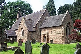
Stretton is a village and former civil parish, now in the parish of Lapley, Stretton and Wheaton Aston, in the South Staffordshire district, in the county of Staffordshire, England. It is just north of the A5 road. In 1961 the parish had a population of 176.
Alice Tibbits (1854–1932) was a South Australian nursing pioneer who was matron and owner of the Private Hospital, Wakefield Street in the 1880s. She was one of the first to train nurses in Australia and was known as the "Florence Nightingale of South Australia".
