
Mobile Bay is a shallow inlet of the Gulf of Mexico, lying within the state of Alabama in the United States. Its mouth is formed by the Fort Morgan Peninsula on the eastern side and Dauphin Island, a barrier island on the western side. The Mobile River and Tensaw River empty into the northern end of the bay, making it an estuary. Several smaller rivers also empty into the bay: Dog River, Deer River, and Fowl River on the western side of the bay, and Fish River on the eastern side. Mobile Bay is the fourth largest estuary in the United States with a discharge of 62,000 cubic feet (1,800 m3) of water per second. Annually, and often several times during the summer months, the fish and crustaceans will swarm the shallow coastline and shore of the bay. This event, appropriately named a jubilee, draws a large crowd because of the abundance of fresh, easily caught seafood.

Grand Bay is an unincorporated community and census-designated place (CDP) in Mobile County, Alabama, United States. It is part of the Mobile metropolitan area. The population was 3,460 at the 2020 census.

The Mobile River is located in southern Alabama in the United States. Formed out of the confluence of the Tombigbee and Alabama rivers, the approximately 45-mile-long (72 km) river drains an area of 44,000 square miles (110,000 km2) of Alabama, with a watershed extending into Mississippi, Georgia, and Tennessee. Its drainage basin is the fourth-largest of primary stream drainage basins entirely in the United States. The river has historically provided the principal navigational access for Alabama. Since construction of the Tennessee-Tombigbee Waterway, it also provides an alternative route into the Ohio River watershed.

The Tensaw River is a river in Baldwin County, Alabama.
Gaillard Island is an artificially created island located in Mobile Bay near Mobile, Alabama. It was built by the United States Army Corps of Engineers, using sand and mud dredged from the Mobile Bay ship channel and elsewhere. The island is an important site for colonial nesting seabirds and shore birds in coastal Alabama and has been the only nesting site for brown pelicans in Alabama - first discovered in 1983.

The Dog River is a river in Mobile County, Alabama. The Dog River watershed drains more than 90 square miles (230 km2). The river is about 8 miles (13 km) long and is influenced by tides. It originates at 30.64158°N 88.09666°W within the city of Mobile. It discharges into Mobile Bay, a tidal estuary on the northern Gulf of Mexico, at 30.56491°N 88.08833°W near Hollinger's Island. It was named by the original French colonists as the Riviere Au Chien, which can be translated into English as Dog River.

The Dauphin Island Bridge, formally the Gordon Persons Bridge, carries a 3-mile (4.8 km), two-lane section of Alabama State Route 193 from mainland Mobile County, Alabama across the Gulf Intracoastal Waterway to Dauphin Island. The natural channel followed by the Gulf Intracoastal Waterway at this location is Pass Aux Herons. The bridge separates the Mississippi Sound on the west from Mobile Bay on the east. It was named in honor of Seth Gordon Persons, the 46th governor of Alabama.

The Mobile Metropolitan Area comprises Mobile and Washington counties in the southwest corner of Alabama in the United States. As of the 2020 census the metropolitan area had a population of 430,197. The Mobile metropolitan area is the third-largest metropolitan area in the state of Alabama, after Birmingham and Huntsville.

USS Bittern (AM-36) was a Lapwing-class minesweeper in the United States Navy. She was named after the bittern, a bird of the heron family. The vessel was constructed by Alabama Dry Dock and Shipbuilding Co., in Mobile, Alabama, and launched on 15 February 1919 and commissioned on 28 May later that year. Initially operating in U.S. coastal waters, the vessel was reassigned to western Pacific operations in 1920, based in the Philippine Islands. Shortly after the U.S. entry into World War II, Bittern was scuttled to avoid capture after being severely damaged during a Japanese air raid on Cavite Navy Yard in December 1941.

Belle Fontaine is an unincorporated community and census-designated place (CDP) in Mobile County, Alabama, United States, on the western shore of Mobile Bay. It is located south of the city of Mobile, along the stretch of shore between the Deer River and the Fowl River. As of the 2020 census, its population was 613.
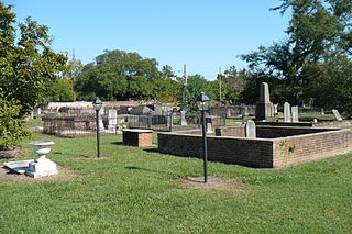
Church Street Graveyard is a historic city cemetery located in Mobile, Alabama. The cemetery is situated on 4 acres (1.6 ha) and is surrounded by a brick wall that dates to 1830. At the time that the cemetery was established it lay about a half mile away from most development, but it is now considered to be in downtown.
Mobile Point is the apex of a long, low, narrow, sandy peninsula between the Gulf of Mexico on the south and Bon Secour Bay and Navy Cove on the north. The point is the eastern limit of the entrance into Mobile Bay, which it partially encloses. It is located in Baldwin County, Alabama. At its western tip is Fort Morgan, which faces Fort Gaines sitting across the inlet to the Mobile Bay, on Dauphin Island. Along the point is the unincorporated community of Fort Morgan, Alabama.
St. Elmo is an unincorporated community in Mobile County, Alabama, United States. It is located approximately seven miles due north of Bayou La Batre and the Mississippi Sound and approximately 10 miles east of Grand Bay.
Mon Louis Island, originally known as Isle aux Maraguans, is an island on the coast of the U.S. state of Alabama, south of Mobile. Located in southeastern Mobile County, it has an average elevation of 7 feet (2.1 m). Roughly 2 miles (3.2 km) wide and 6 miles (9.7 km) long, it is bounded by Fowl River on the north and west, Mobile Bay on the east, and the Mississippi Sound on the south. Mon Louis is traversed by Alabama State Route 193, which travels in a north to south direction along the eastern edge of the island. The Gordon Persons Bridge on the southern end of Route 193 connects the island to Dauphin Island. The unincorporated communities of Alabama Port, Heron Bay, and Mon Louis are located on the island.

Alabama Port, also sometimes known as Port Alabama, is an unincorporated community on Mon Louis Island, in Mobile County, Alabama, United States.

CSS Huntsville was a Confederate ironclad floating battery built at Selma, Alabama, from 1862 to 1863 during the American Civil War.
CSS Phoenix was a Confederate ironclad floating battery built at Selma, Alabama, from 1863–64.

Blakeley Island is an island in the U.S. state of Alabama, within the city limits of Mobile. Located on the northwestern coast of Mobile Bay, it is bounded on the west by the Mobile River, on the south by Pinto Island and Mobile Bay, and on the east and north by the Spanish River. Blakeley serves as a vital road connection point between the Bankhead Tunnel, George Wallace Tunnel, and Cochrane–Africatown USA Bridge on its east side and the Battleship Parkway and Jubilee Parkway on its west side. The northern end is largely undeveloped, while the southern end is dedicated to industrial uses, primarily petrochemical storage and shipbuilding. The largest complex is the shipyards of Austal USA. Approximately 1.25 miles (2.01 km) at its widest and 6 miles (9.7 km) at its longest, it has an average elevation of 7 feet (2.1 m). It, along with downtown, forms District Two of Mobile's city council districts.

Pinto Island is an island in the U.S. state of Alabama, within the city limits of Mobile. Located on the northwestern coast of Mobile Bay, it is bounded on the west by the Mobile River, on the south by Mobile Bay, on the east by the Spanish River, and on the north by Pinto Pass and Blakeley Island. It is dedicated to industrial uses, primarily shipbuilding. The BAE Systems Southeast Shipyards was originally the site of the Alabama Drydock and Shipbuilding Company, and most recently Atlantic Marine, which was acquired by BAE in 2010. The Alabama State Port Authority operates a terminal on the southern end of the island for the ThyssenKrupp steel plant upriver in Calvert. Austal USA owns part of this Island chain taking up most of the central part with a stocking shop channel on the west bank. In June 2018 BAE Systems Southeast completed a total shutdown of all facilities on Pinto Island, selling all their land and ship yards to Austal USA, giving Austal USA 51% control of Pinto Island land area from center to South shore.
The Spanish River is a brackish distributary river that forms part of the border between Baldwin and Mobile counties in Alabama. It is approximately 8 miles (13 km) long and is influenced by tides. It begins at the northernmost tip of Blakeley Island, where it diverges from the Mobile River, at 30.772°N 88.0222°W. From there it flows along the eastern edge of Blakeley and Pinto islands, and discharges into Mobile Bay south of Pinto Island, at 30.665°N 88.021°W.


