Jackson County is a county located in the U.S. state of Mississippi. As of the 2020 census, the population was 143,252, making it the fifth-most populous county in Mississippi. Its county seat is Pascagoula. The county was named for Andrew Jackson, general in the United States Army and afterward President of the United States.

Prichard is a city in Mobile County, Alabama, United States. As of the 2020 census, the population of the city was 19,322, down from 22,659 at the 2010 census. It is a part of the Mobile metropolitan area. Prichard borders the north side of Mobile, as well as the Mobile suburbs of Chickasaw, Saraland, and the unincorporated sections of Eight Mile.

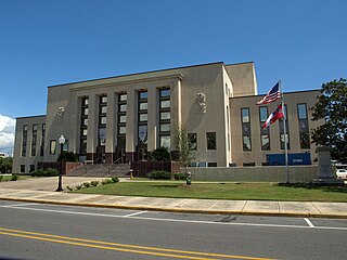
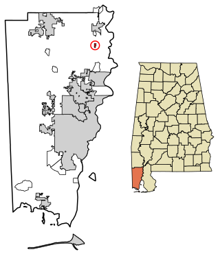
Gainesville is a town in Sumter County, Alabama, United States. Founded in 1832, it was incorporated in 1835. At the 2010 census the population was 208, down from 220. Confederate Lieutenant General Nathan Bedford Forrest surrendered his men near Gainesville on May 19, 1865, at the Civil War's end.

Coden is an unincorporated community coastal fishing village in southern Mobile County, Alabama, United States. Located near Bayou la Batre, it lies across the Mississippi Sound from Dauphin Island.

Toulminville is a neighborhood of Mobile, Alabama, United States. It began as a small settlement on the property of Harry Theophilus Toulmin, who served as Sheriff of Mobile County in the 1830s. During the American Civil War, Toulminville was mapped along the Mobile and Ohio Railroad as a significant settlement, northwest of Mobile. In 1945, the remainder of Toulminville was annexed into the city of Mobile. The area of Toulminville has varied over the past decades from being an upper-middle class suburb to having a serious crime problem during most of the 1980s and 1990s, although the trend has been reversed in recent years.

The Mobile Metropolitan Area comprises Mobile and Washington counties in the southwest corner of Alabama in the United States. As of the 2020 census the metropolitan area had a population of 430,197. The Mobile metropolitan area is the third-largest metropolitan area in the state of Alabama, after Birmingham and Huntsville.

Semmes is a city in western Mobile County, Alabama, in the Mobile metropolitan area. It was incorporated in 2011. As of the 2020 census, the population was 4,941.

Belle Fontaine is an unincorporated community and census-designated place (CDP) in Mobile County, Alabama, United States, on the western shore of Mobile Bay. It is located south of the city of Mobile, along the stretch of shore between the Deer River and the Fowl River. As of the 2020 census, its population was 613.

Langan Park, also known as Municipal Park, is a 720-acre (291 ha) municipal park in the Spring Hill neighborhood of Mobile, Alabama, USA. The park opened in 1957 and was named for Joseph N. Langan, a former Mobile mayor, state senator and city commissioner. It has lakes, natural spaces, tennis courts, children’s playgrounds and picnic areas. It is also the site of the Azalea City Golf Course, the Mobile Botanical Gardens, the Mobile Museum of Art and Playhouse in the Park.
Bucks is an unincorporated community and census-designated place (CDP) in Mobile County, Alabama, United States. As of the 2020 census, its population was 22, down from 32 at the 2010 census. It is located in the northeastern section of the county near the Mobile River, along U.S. Route 43. The James M. Barry Electric Generating Plant, a coal- and natural gas-fired power station operated by Alabama Power, is located in Bucks.
Mauvilla is an unincorporated community in Mobile County, Alabama, United States. A post office operated under the name Mauvilla in 1856 and from 1895 to 1912.
St. Elmo is an unincorporated community in Mobile County, Alabama, United States. It is located approximately seven miles due north of Bayou La Batre and the Mississippi Sound and approximately 10 miles east of Grand Bay.
Irvington is an unincorporated community located along U.S. Route 90, east of St. Elmo and north of Bayou La Batre in southwestern Mobile County, Alabama, United States. It has a post office utilizing the 36544 ZIP code and is home to the Mobile International Speedway and Silver King Golf Course.

Chunchula is an unincorporated community and census-designated place (CDP) in Mobile County, Alabama, United States. As of the 2020 census, its population was 195. It has a post office with the 36521 ZIP code. The community has one site listed on the Alabama Register of Landmarks and Heritage, the Chunchula School.

Axis is an unincorporated community and census-designated place (CDP) in Mobile County, Alabama, United States. As of the 2020 census, it had a population of 561, down from 757 at the 2010 census. It has a post office with the 36505 ZIP code. The community has one site listed on the Alabama Register of Landmarks and Heritage, the Kirk House.
Le Moyne is an unincorporated community in Mobile County, Alabama, United States. It was named in honor of the Le Moyne brothers, Pierre Le Moyne d'Iberville and Jean-Baptiste Le Moyne, Sieur de Bienville, founders of colonial Mobile. Twenty-Seven Mile Bluff, on the Mobile River, is located in Le Moyne. The bluff is the site of the former Fort Louis de La Louisiane, capital of French Louisiana from 1702 until 1711.
Mon Louis is an unincorporated community on Mon Louis Island, in Mobile County, Alabama, United States.

Alabama Port, also sometimes known as Port Alabama, is an unincorporated community on Mon Louis Island, in Mobile County, Alabama, United States.
Heron Bay is an unincorporated community on Mon Louis Island, in Mobile County, Alabama, United States.


