Bucks, Alabama

Last updated

Bucks, Alabama
Mobile County Alabama Incorporated and Unincorporated areas Bucks Highlighted 0110456.svg
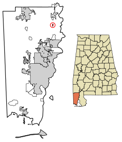
Location in Mobile County, Alabama
USA Alabama location map.svg
Red pog.svg
Bucks
Coordinates: 31°1′7.72″N88°1′27.07″W / 31.0188111°N 88.0241861°W / 31.0188111; -88.0241861
Country United States
State Alabama
County Mobile
Area
[1]
  Total0.42 sq mi (1.10 km2)
  Land0.39 sq mi (1.00 km2)
  Water0.04 sq mi (0.09 km2)
Elevation
49 ft (15 m)
Population
 (2020) [2]
  Total22
  Density56.85/sq mi (21.93/km2)
Time zone UTC-6 (Central (CST))
  Summer (DST) UTC-5 (CDT)
ZIP code
36512
Area code 251
FIPS code 01-10456

Bucks is an unincorporated community and census-designated place (CDP) in Mobile County, Alabama, United States. [3] As of the 2020 census, its population was 22, [2] down from 32 at the 2010 census. [4] It is located in the northeastern section of the county near the Mobile River, along U.S. Route 43. The James M. Barry Electric Generating Plant, a coal- and natural gas-fired power station operated by Alabama Power, is located in Bucks.

Contents

Demographics

Historical population
CensusPop.Note
2020 22
U.S. Decennial Census [5]

In 2010, Bucks had a population of 32. The racial and ethnic composition of the population was 59.4% white, 31.3% black or African American, 3.1% Native American, 6.3% from two or more races and 3.1% Hispanic or Latino of any race. [6]

Geography

Bucks is located at 31°1′7.72″N88°1′27.07″W / 31.0188111°N 88.0241861°W / 31.0188111; -88.0241861 . The elevation is 49 feet (15 m). [3] U.S. Route 43, the only highway through the community, leads south 23 miles (37 km) to Mobile and north 5 miles (8 km) to Mount Vernon.

According to the U.S. Census Bureau, the Bucks CDP has an area of 0.42 square miles (1.1 km2), of which 0.04 square miles (0.10 km2), or 8.51%, are water. [1] The Mobile River forms the eastern edge of the community.

Education

Residents are zoned to Mobile County Public School System campuses. [7] Residents are zoned to Citronelle High School. [8]

Related Research Articles

<span class="mw-page-title-main">Montgomery County, Alabama</span> County in Alabama, United States

Montgomery County is located in the State of Alabama. As of the 2020 census, its population was 228,954, making it the seventh-most populous county in Alabama. Its county seat is Montgomery, the state capital. Montgomery County is included in the Montgomery Metropolitan Statistical Area.

<span class="mw-page-title-main">Mobile County, Alabama</span> County in Alabama, United States

Mobile County is located in the southwestern corner of the U.S. state of Alabama. It is the third-most populous county in the state after Jefferson and Madison counties. As of the 2020 census, its population was 414,809. Its county seat is Mobile, which was founded as a deepwater port on the Mobile River. The only such port in Alabama, it has long been integral to the economy for providing access to inland waterways as well as the Gulf of Mexico.

<span class="mw-page-title-main">Citronelle, Alabama</span> City in the United States

Citronelle is a city on the northern border of Mobile County, Alabama, United States. At the 2020 census, the population was 3,946. It is included in the Mobile metropolitan statistical area and is about 34 miles (55 km) north of Mobile.

<span class="mw-page-title-main">Creola, Alabama</span> City in Alabama, United States

Creola is a city in Mobile County, Alabama, United States. Incorporated in 1978, the city had a population of 1,936 at the 2020 census. It is part of the Mobile metropolitan area.

<span class="mw-page-title-main">Grand Bay, Alabama</span> Census-designated place in Alabama, United States

Grand Bay is an unincorporated community and census-designated place (CDP) in Mobile County, Alabama, United States. It is part of the Mobile metropolitan area. The population was 3,460 at the 2020 census.

<span class="mw-page-title-main">Mount Vernon, Alabama</span> Town in Alabama, United States

Mount Vernon is a town in Mobile County, Alabama, United States. It is part of the Mobile metropolitan area. It incorporated in 1959. At the 2020 census the population was 1,354.

<span class="mw-page-title-main">Saraland, Alabama</span> City in Alabama, United States

Saraland is a city in Mobile County, Alabama, United States, and a suburb of Mobile. As of the 2020 census, the population of the city was 16,171, up from 13,405 at the 2010 census. Saraland, part of the Mobile metropolitan area, is the third largest city in Mobile County.

<span class="mw-page-title-main">Theodore, Alabama</span> Census-designated place in Alabama, United States

Theodore is an unincorporated area and census-designated place (CDP) in Mobile County, Alabama, United States. The population was 6,270 at the 2020 census. It is a part of the Mobile metropolitan area. Prior to 1900 this area was known as "Clements", but it is now named for William Theodore Hieronymous, a sawmill operator and postmaster.

<span class="mw-page-title-main">Tillmans Corner, Alabama</span> Unincorporated community in Alabama, United States

Tillmans Corner, or Tillman’s Corner, is an unincorporated community and census-designated place (CDP) in Mobile County, Alabama, United States. At the 2020 census, the population was 17,731. It is part of the Mobile metropolitan area, and is the largest census-designated place in Alabama.

Forest Lake is an unincorporated community and census-designated place (CDP) in Ela Township of Lake County, Illinois, United States. It is about 35 miles (56 km) northwest of downtown Chicago. Per the 2020 census, the population was 1,784. The community was founded in 1935 as a vacation community for Chicago residents.

<span class="mw-page-title-main">Concord, Missouri</span> CDP in Missouri, United States

Concord is a census-designated place (CDP) in St. Louis County, Missouri, United States. The population was 16,421 at the 2010 census. It should not be confused with Concord Township, which the CDP shares much land with, but these areas' boundaries are not identical.

<span class="mw-page-title-main">Westway, Texas</span> Census-designated place in Texas, United States

Westway is a census-designated place (CDP) in El Paso County, Texas, United States. The population was 4,188 at the 2010 census. It is part of the El Paso Metropolitan Statistical Area. It is located east of Interstate 10, approximately 2 miles (3 km) from the New Mexico - Texas state line. The ZIP Code encompassing the CDP area is 79835.

<span class="mw-page-title-main">Hillandale, Maryland</span> Census-designated place in Maryland, United States

Hillandale is an unincorporated area and census-designated place located in Montgomery and Prince George's counties, Maryland, United States. As of the 2020 census, it had a population of 5,774. Hillandale is contained between the Prince George's / Montgomery County line to the east, the Anacostia River to the west, McCeney Avenue to the north, and D.C.'s Capital Beltway to the south. It borders the communities of Adelphi, Avenel, White Oak and Beltsville.

Peppermill Village is an unincorporated community near Maryland Route 214 in Prince George's County, Maryland, United States. Per the 2020 census, the population was 5,264. FedExField, Metrorail's Blue Line, and Hampton Mall shopping center are all located nearby. Because it is not formally incorporated, it has no official boundaries, but the United States Census Bureau has defined a census-designated place (CDP) consisting of Peppermill Village and the adjacent community of Carmody Hills, for statistical purposes.

<span class="mw-page-title-main">Chunchula, Alabama</span> Census-designated place in Alabama, United States

Chunchula is an unincorporated community and census-designated place (CDP) in Mobile County, Alabama, United States. As of the 2020 census, its population was 195. It has a post office with the 36521 ZIP code. The community has one site listed on the Alabama Register of Landmarks and Heritage, the Chunchula School.

<span class="mw-page-title-main">Axis, Alabama</span> Unincorporated community in Alabama, United States

Axis is an unincorporated community and census-designated place (CDP) in Mobile County, Alabama, United States. As of the 2020 census, it had a population of 561, down from 757 at the 2010 census. It has a post office with the 36505 ZIP code. The community has one site listed on the Alabama Register of Landmarks and Heritage, the Kirk House.

<span class="mw-page-title-main">Calvert, Alabama</span> Census-designated place in Alabama, United States

Calvert is an unincorporated community and census-designated place (CDP) in Mobile and Washington counties, Alabama, United States. It is located in the extreme northeast corner of Mobile County and southeast corner of Washington County near the Tombigbee River, along U.S. Route 43. As of the 2020 census, the population of Calvert was 255.

<span class="mw-page-title-main">Gulfcrest, Alabama</span> Census-designated place in Alabama, United States

Gulfcrest is a census-designated place and unincorporated community in Mobile County, Alabama, United States. Its population was 142 as of the 2020 census.

<span class="mw-page-title-main">Movico, Alabama</span> Census-designated place in Alabama, United States

Movico is a census-designated place and unincorporated community in Mobile County, Alabama, United States. Its population was 291 as of the 2020 census. The town was heavily damaged by an EF2 tornado on January 12, 2023.

<span class="mw-page-title-main">Citronelle High School</span> Public school in Citronelle, Alabama, United States

Citronelle High School is a senior high school in Citronelle, Alabama. It is a part of the Mobile County Public School System.

References

  1. 1 2 "2021 U.S. Gazetteer Files". United States Census Bureau. Retrieved April 21, 2022.
  2. 1 2 "Bucks CDP, Alabama: 2020 DEC Redistricting Data (PL 94-171)". U.S. Census Bureau. Retrieved April 21, 2022.
  3. 1 2 "Bucks, Alabama". Alabama Home Town Locator. Retrieved March 9, 2008.
  4. "U.S. Census website". United States Census Bureau . Retrieved May 14, 2011.
  5. "Census of Population and Housing". Census.gov. Retrieved June 4, 2016.
  6. 2010 population by race and Hispanic or Latino by place report for Alabama from the US Census]
  7. "2010 CENSUS - CENSUS BLOCK MAP: Bucks CDP, AL." U.S. Census Bureau. Retrieved on November 27, 2018.
  8. "Citronelle High School Attendance Zone Archived 2021-07-25 at the Wayback Machine ." Mobile County Public School System. Retrieved on November 27, 2018.