
Mobile County is located in the southwestern corner of the U.S. state of Alabama. It is the second most-populous county in the state after Jefferson County. As of the 2020 census, its population was 414,809. Its county seat is Mobile, which was founded as a deepwater port on the Mobile River. The only such port in Alabama, it has long been integral to the economy for providing access to inland waterways as well as the Gulf of Mexico.

George County is a county located in the U.S. state of Mississippi. As of the 2010 census, the population was 22,578. Its county seat is Lucedale. The county is named for James Z. George, US Senator from Mississippi.

Coden is an unincorporated community coastal fishing village in southern Mobile County, Alabama, United States. Located near Bayou la Batre, it lies across the Mississippi Sound from Dauphin Island.

The Tombigbee River is a tributary of the Mobile River, approximately 200 mi (325 km) long, in the U.S. states of Mississippi and Alabama. Together with the Alabama, it merges to form the short Mobile River before the latter empties into Mobile Bay on the Gulf of Mexico. The Tombigbee watershed encompasses much of the rural coastal plain of western Alabama and northeastern Mississippi, flowing generally southward. The river provides one of the principal routes of commercial navigation in the southern United States, as it is navigable along much of its length through locks and connected in its upper reaches to the Tennessee River via the Tennessee-Tombigbee Waterway.

The Mobile River is located in southern Alabama in the United States. Formed out of the confluence of the Tombigbee and Alabama rivers, the approximately 45-mile-long (72 km) river drains an area of 44,000 square miles (110,000 km2) of Alabama, with a watershed extending into Mississippi, Georgia, and Tennessee. Its drainage basin is the fourth-largest of primary stream drainage basins entirely in the United States. The river has historically provided the principal navigational access for Alabama. Since construction of the Tennessee-Tombigbee Waterway, it also provides an alternative route into the Ohio River watershed.

Toulminville is a neighborhood of Mobile, Alabama, United States. It began as a small settlement on the property of Harry Theophilus Toulmin, who served as Sheriff of Mobile County in the 1830s. During the American Civil War, Toulminville was mapped along the Mobile and Ohio Railroad as a significant settlement, northwest of Mobile. In 1945, the remainder of Toulminville was annexed into the city of Mobile. The area of Toulminville has varied over the past decades from being an upper-middle class suburb to having a serious crime problem during most of the 1980s and 1990s, although the trend has been reversed in recent years.

Metropolitan Mobile has a population of 430,197 within Mobile County Alabama in the southwestern tip of Alabama. The Mobile metropolitan area is the third-largest metropolitan area in the state of Alabama.

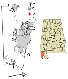
Belle Fontaine is an unincorporated community and census-designated place in Mobile County, Alabama, United States, on the western shore of Mobile Bay. It is located south of the city of Mobile, along the stretch of shore between Deer River and Fowl River. As of the 2010 census, its population was 608.
Bucks is an unincorporated community and census-designated place in Mobile County, Alabama, United States. As of the 2010 census, its population was 32. It is located in the northeastern section of the county near the Mobile River, along U.S. Route 43. The James M. Barry Electric Generating Plant, a coal- and natural gas-fired power station operated by Alabama Power, is located in Bucks.
Kushla is an unincorporated community in Mobile County, Alabama, United States. A post office operated under the name Kushla from 1887 to 1919.
St. Elmo is an unincorporated community in Mobile County, Alabama, United States. It is located approximately seven miles due north of Bayou La Batre and the Mississippi Sound and approximately 10 miles east of Grand Bay.

Irvington is an unincorporated community located along U.S. Route 90, east of St. Elmo and north of Bayou La Batre in southwestern Mobile County, Alabama, United States. It has a post office utilizing the 36544 ZIP code and is home to the Mobile International Speedway and Silver King Golf Course.

John L. LeFlore Magnet High School of Advanced Communication and Fine Arts is a historic public magnet performing arts high school located in Toulminville, Mobile, Alabama, United States. The school is also accredited by the Southern Association of Colleges and Schools. It currently enrolls 947 students in grades 9-12, and is a part of the Mobile County Public School System.

Chunchula is an unincorporated community and census-designated place in Mobile County, Alabama, United States. As of the 2010 census, its population was 210. It has a post office with the 36521 ZIP code. The community has one site listed on the Alabama Register of Landmarks and Heritage, the Chunchula School.

Axis is an unincorporated community and census-designated place in Mobile County, Alabama, United States. It has a post office with the 36505 ZIP code. The community has one site listed on the Alabama Register of Landmarks and Heritage, the Kirk House.
Le Moyne is an unincorporated community in Mobile County, Alabama, United States. It was named in honor of the Le Moyne brothers, Pierre Le Moyne d'Iberville and Jean-Baptiste Le Moyne, Sieur de Bienville, founders of colonial Mobile. Twenty-Seven Mile Bluff, on the Mobile River, is located in Le Moyne. The bluff is the site of the former Fort Louis de La Louisiane, capital of French Louisiana from 1702 until 1711.
Mon Louis is an unincorporated community on Mon Louis Island, in Mobile County, Alabama, United States.

Alabama Port, also sometimes known as Port Alabama, is an unincorporated community on Mon Louis Island, in Mobile County, Alabama, United States.
Heron Bay is an unincorporated community on Mon Louis Island, in Mobile County, Alabama, United States.

The Davis-Oak Grove District is a historic district near Mauvilla in rural Mobile County, Alabama, United States. It is on the western side of Oak Grove Road, north of the intersection with Kali Oka Road. The district covers 12.2 acres (0.049 km2) and contains 16 contributing properties. It was placed on the National Register of Historic Places on May 3, 1988.


