
Mobile County is a county located in the southwestern corner of the U.S. state of Alabama. It is the third-most populous county in the state after Jefferson and Madison counties. As of the 2020 census, its population was 414,809. Its county seat is Mobile, which was founded as a deepwater port on the Mobile River. The only such port in Alabama, it has long been integral to the economy for providing access to inland waterways as well as the Gulf of Mexico.

Bayou La Batre is a city in Mobile County, Alabama, United States. It is part of the Mobile metropolitan area. As of the 2020 census, the population was 2,204, down from 2,558 at the 2010 census.

Chickasaw is a city in Mobile County, Alabama, United States. As of the 2020 census the population was 6,457, up from 6,106 at the 2010 census. It is part of the Mobile metropolitan area.

Citronelle is a city on the northern border of Mobile County, Alabama, United States. At the 2020 census, the population was 3,946. It is included in the Mobile metropolitan statistical area and is about 34 miles (55 km) north of Mobile.

Dauphin Island is an island town in Mobile County, Alabama, United States, on a barrier island of the same name, in the Gulf of Mexico. It incorporated in 1988. The population was 1,778 at the 2020 census, up from 1,238 at the 2010 census. The town is part of the Mobile metropolitan area. The island was renamed for Louis XIV of France's great-grandson and heir, the dauphin, the future Louis XV of France. The name of the island is often mistaken as Dolphin Island; the word dauphin is French for dolphin, but historically, the term was used as the title of the heir apparent to the French monarch.

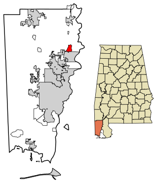
Grand Bay is an unincorporated community and census-designated place (CDP) in Mobile County, Alabama, United States. It is part of the Mobile metropolitan area. The population was 3,460 at the 2020 census.

Mount Vernon is a town in Mobile County, Alabama, United States. It is part of the Mobile metropolitan area. It incorporated in 1959. At the 2020 census the population was 1,354.

Prichard is a city in Mobile County, Alabama, United States. The population was 19,322 at the 2020 census, and was estimated to be 18,870 in 2022. Prichard borders the north side of Mobile, as well as the Mobile suburbs of Chickasaw, Saraland, and the unincorporated sections of Eight Mile.

Mobile County Public School System (MCPSS) is a school district based in unincorporated Mobile County, Alabama, United States. The system currently serves areas of Mobile County, including the city of Mobile, with the exception of the cities of Saraland, Satsuma and Chickasaw. Saraland voted to separate its schools from Mobile County in 2006, with Satsuma and Chickasaw following suit in 2012. The system serves urban, suburban, and rural areas. All schools in the system are required to adopt school uniform policies. It is the largest school system in Alabama and the 71st largest school system in the United States.

The Mobile Metropolitan Area comprises Mobile in the southwest corner of Alabama in the United States. As of the 2020 census the metropolitan area had a population of 430,197. The Mobile metropolitan area is the third-largest metropolitan area in the state of Alabama, after Birmingham and Huntsville. Washington County was part of the Mobile metropolitan area but was removed when the OMB released its statistical definitions effective July 2023.

Semmes is a city in western Mobile County, Alabama, in the Mobile metropolitan area. It was incorporated in 2011. As of the 2020 census, the population was 4,941.

St. Luke's Church, also known as 'The Parish Church of the Mountains' is a congregation in the Anglican (Episcopal) tradition, located in Blue Ridge, Georgia. Founded in 1987 under the auspices of the Traditional Protestant Episcopal Foundation of Alabama, it is now part of the Diocese of the South of the Episcopal Missionary Church (Anglican), and is in communion with the Anglican Church of North America and GAFCON Global Anglican provinces.
Baker High School is located in unincorporated Mobile County, Alabama, west of Mobile, and is a public high school operated by the Mobile County Public School System. The school educates students in grades 9-12. Baker High School is the largest high school in Mobile County with over 2,300 students enrolled and the second largest school in the state of Alabama.
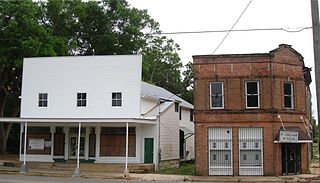
Grand Bay Historic District is a historic district in Grand Bay, Alabama. Listed on the National Register of Historic Places in 1990, the district comprises twelve acres and the three remaining original buildings from Grand Bay's central business district. The buildings include the former Freeland General Store, Grand Bay State Bank, and a small commercial building. The site was once the central business hub of the town and included an L&N passenger station, railway freight station, numerous packing houses, and additional general mercantile businesses.
Alma Bryant High School is a public high school located in Irvington, Alabama, United States, off State Highway 188 between Grand Bay and Bayou La Batre.
Fernland is an unincorporated community in Mobile County, Alabama, United States. Fernland lies along U.S. Route 90 midway between the towns of Grand Bay to the west and St. Elmo to the east. The community originally formed around a sawmill with its own post office and rail service. During the days of segregation, elementary students attended Grand Bay Elementary School for Colored, which was located in the community. Current high school students attend Alma Bryant High School.

Chunchula is an unincorporated community and census-designated place (CDP) in Mobile County, Alabama, United States. As of the 2020 census, its population was 195. It has a post office with the 36521 ZIP code. The community has one site listed on the Alabama Register of Landmarks and Heritage, the Chunchula School.
Axis is an unincorporated community and census-designated place (CDP) in Mobile County, Alabama, United States. As of the 2020 census, it had a population of 561, down from 757 at the 2010 census. It has a post office with the 36505 ZIP code. The community has one site listed on the Alabama Register of Landmarks and Heritage, the Kirk House.
Thomas Christopher "Chris" Elliott is an American politician and state senator in the Alabama Senate in Senate District 32.
Matt Simpson is an American politician currently serving in his second term in the Alabama House of Representatives for House District 96, which he was elected to in November 2018. He is a member of the Republican Party.


