Hickory Hills, Mississippi

Last updated
Hickory Hills, Mississippi
Former CDP
Jackson County Mississippi Incorporated and Unincorporated areas Hickory Hills Highlighted.svg
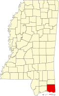
Location of Hickory Hills, Mississippi
Usa edcp location map.svg
Red pog.svg
Hickory Hills, Mississippi
Location in the United States
Coordinates: 30°27′18″N88°38′26″W / 30.45500°N 88.64056°W / 30.45500; -88.64056 Coordinates: 30°27′18″N88°38′26″W / 30.45500°N 88.64056°W / 30.45500; -88.64056
Country United States
State Mississippi
County Jackson
Area
  Total5.7 sq mi (14.8 km2)
  Land5.4 sq mi (13.9 km2)
  Water0.3 sq mi (0.9 km2)
Elevation
20 ft (6 m)
Population
 (2000)
  Total3,046
  Density567/sq mi (219.1/km2)
Time zone UTC-6 (Central (CST))
  Summer (DST) UTC-5 (CDT)
FIPS code 28-32082
GNIS feature ID1852587

Hickory Hill is a neighborhood in the city of Gautier in Jackson County, Mississippi, United States. Prior to 2010 it was an unincorporated area and recorded as a census-designated place, with a population of 3,046 at the 2000 census. At the 2010 census its population was included in the data for the city of Gautier. It is part of the Pascagoula Metropolitan Statistical Area.

Contents

Geography

Hickory Hills is located in the northern part of the city of Gautier at 30°27′18″N88°38′26″W / 30.45500°N 88.64056°W / 30.45500; -88.64056 (30.454907, -88.640579), [1] north of Interstate 10, with access from Exit 61. It is 8 miles (13 km) by road north of the center of Gautier, 12 miles (19 km) northwest of Pascagoula, the county seat, and 19 miles (31 km) northeast of Biloxi.

Demographics

As of the census [2] of 2000, there were 3,046 people, 1,085 households, and 848 families residing in the CDP. The population density was 567.4 inhabitants per square mile (219.1/km2). There were 1,263 housing units at an average density of 235.3 per square mile (90.8/km2). The racial makeup of the CDP was 82.11% White, 14.31% African American, 0.56% Native American, 0.49% Asian, 0.82% from other races, and 1.71% from two or more races. Hispanic or Latino of any race were 2.50% of the population.

There were 1,085 households, out of which 40.1% had children under the age of 18 living with them, 60.6% were married couples living together, 12.2% had a female householder with no husband present, and 21.8% were non-families. 17.0% of all households were made up of individuals, and 4.6% had someone living alone who was 65 years of age or older. The average household size was 2.80 and the average family size was 3.12.

In the CDP, the population was spread out, with 29.3% under the age of 18, 8.9% from 18 to 24, 31.6% from 25 to 44, 23.0% from 45 to 64, and 7.3% who were 65 years of age or older. The median age was 33 years. For every 100 females, there were 102.9 males. For every 100 females age 18 and over, there were 98.7 males.

The median income for a household in the CDP was $44,479, and the median income for a family was $49,719. Males had a median income of $35,385 versus $25,733 for females. The per capita income for the CDP was $19,714. About 12.9% of families and 17.8% of the population were below the poverty line, including 27.5% of those under age 18 and 9.0% of those age 65 or over.

Education

Hickory Hills is served by the Pascagoula-Gautier School District. It includes one elementary school, one middle school, and one high school. Students in Hickory Hills attend schools in Gautier.

Elementary school

Middle school

High school

Related Research Articles

<span class="mw-page-title-main">Jackson County, Mississippi</span> County in Mississippi, United States

Jackson County is a county located in the U.S. state of Mississippi. As of the 2020 census, the population was 143,252, making it the fifth-most populous county in Mississippi. Its county seat is Pascagoula. The county was named for Andrew Jackson, general in the United States Army and afterward President of the United States.

<span class="mw-page-title-main">Theodore, Alabama</span> Census-designated place in Alabama, United States

Theodore is an unincorporated area and census-designated place (CDP) in Mobile County, Alabama, United States. The population was 6,270 at the 2020 census. It is a part of the Mobile metropolitan area. Prior to 1900 this area was known as "Clements", but it is now named for William Theodore Hieronymous, a sawmill operator and postmaster.

<span class="mw-page-title-main">Tillmans Corner, Alabama</span> Unincorporated community in Alabama, United States

Tillman's Corner is an unincorporated community and census-designated place (CDP) in Mobile County, Alabama, United States. At the 2020 census, the population was 17,731. It is a part of the Mobile metropolitan area.

<span class="mw-page-title-main">Peridot, Arizona</span> CDP in Gila and Graham Counties, Arizona, US

Peridot is an unincorporated community and census-designated place (CDP) in Gila and Graham counties in the U.S. state of Arizona. The population was 1,350 at the 2010 census.

<span class="mw-page-title-main">Sedco Hills, California</span> CDP in California, United States

Sedco Hills is a former census-designated place (CDP) in Riverside County, California, United States. The population was 3,078 at the 2000 census. Sedco Hills became part of the City of Wildomar upon its incorporation on July 1, 2008.

<span class="mw-page-title-main">Big Point, Mississippi</span> Census-designated place in Mississippi, United States

Big Point is an unincorporated community and census-designated place (CDP) in Jackson County, Mississippi, United States. It is part of the Pascagoula, Mississippi Metropolitan Statistical Area. Per the 2020 Census, the population was 618.

<span class="mw-page-title-main">Escatawpa, Mississippi</span> Census-designated place in Mississippi, United States

Escatawpa is an unincorporated community and census-designated place (CDP) in Jackson County, Mississippi, United States. It is part of the Pascagoula Metropolitan Statistical Area. The population was 3,254 at the 2020 census.

<span class="mw-page-title-main">Gautier, Mississippi</span> City Gautier in Mississippi, United States

Gautier is a city in Jackson County, Mississippi, United States, along the Gulf of Mexico west of Pascagoula. It is part of the Pascagoula Metropolitan Statistical Area. The population was 18,572 at the 2010 census, up from 11,681 at the 2000 census. In 2002, Gautier had annexed land more than doubling its area.

<span class="mw-page-title-main">Gulf Park Estates, Mississippi</span> Census-designated place in Mississippi, United States

Gulf Park Estates is an unincorporated community and census-designated place (CDP) located south of Ocean Springs in Jackson County, Mississippi, United States. It is part of the Pascagoula Metropolitan Statistical Area. The population was 5,719 at the 2010 census, up from 4,272 at the 2000 census.

<span class="mw-page-title-main">Hurley, Mississippi</span> Census-designated place in Mississippi

Hurley is an unincorporated community and census-designated place (CDP) in Jackson County, Mississippi, United States. It is part of the Pascagoula Metropolitan Statistical Area. The population was 1,551 at the 2010 census, up from 985 at the 2000 census.

<span class="mw-page-title-main">St. Martin, Mississippi</span> Census-designated place in Mississippi

St. Martin is a census-designated place (CDP) in Jackson County, Mississippi, United States. It is part of the Pascagoula Metropolitan Statistical Area. The population was 7,730 at the 2010 census, up from 6,676 at the 2000 census.

<span class="mw-page-title-main">Vancleave, Mississippi</span> Census-designated place in Mississippi

Vancleave is an unincorporated community and census-designated place (CDP) in Jackson County, Mississippi, United States. It is part of the Pascagoula Metropolitan Statistical Area. The population was 5,886 at the 2010 census, up from 4,910 at the 2000 census.

<span class="mw-page-title-main">Wade, Mississippi</span> Census-designated place in Mississippi, United States

Wade is an unincorporated community and census-designated place (CDP) in Jackson County, Mississippi, United States. It is part of the Pascagoula Metropolitan Statistical Area. The population was 1,074 at the 2010 census, up from 491 at the 2000 census.

<span class="mw-page-title-main">St. Stephens, North Carolina</span> Census-designated place in North Carolina, United States

St. Stephens is a census-designated place (CDP) in Catawba County, North Carolina, United States. The population was 8,759 at the 2010 census, down from 9,439 in 2000. It is part of the Hickory–Lenoir–Morganton Metropolitan Statistical Area.

<span class="mw-page-title-main">Red Hill, South Carolina</span> Census-designated place in South Carolina, United States

Red Hill is a census-designated place (CDP) in Horry County, South Carolina, United States. The population was 13,223 at the 2010 census, up from 10,509 at the 2000 census.

<span class="mw-page-title-main">Ridgefield (CDP), Connecticut</span> Census-designated place in Connecticut, United States

Ridgefield is a census-designated place (CDP) in Fairfield County, Connecticut, United States. It consists of the primary central village in the town of Ridgefield and surrounding residential areas. As of the 2010 census, the population of the CDP was 7,645, out of 24,638 in the entire town.

<span class="mw-page-title-main">Oak Hill, Maine</span> Census-designated place in Maine, United States

Oak Hill is a census-designated place (CDP) in the town of Scarborough in Cumberland County, Maine, United States. Prior to the 2020 census, the CDP was known as Scarborough. The population was 4,403 at the 2010 census. It is part of the Portland–South Portland–Biddeford, Maine Metropolitan Statistical Area.

<span class="mw-page-title-main">Gulfport–Biloxi metropolitan area</span>

The Gulfport-Biloxi Metropolitan Statistical Area is a metropolitan statistical area (MSA) in the Mississippi Gulf Coast region that includes four counties – Hancock, Harrison, Jackson and Stone. The principal cities are Gulfport and Biloxi. The 2010 census placed the Gulfport-Biloxi MSA population at 388,488, though as of 2019, it was estimated to have increased to 417,665. The area was significantly impacted by Hurricane Katrina on August 29, 2005, and prior to the hurricane, had experienced steady to moderate population growth. However, growth has since rebounded, with the population steadily increasing every year throughout the 2010s.

<span class="mw-page-title-main">Pascagoula metropolitan area</span>

The Pascagoula Metropolitan Statistical Area is a metropolitan area in the southeastern corner of Mississippi that covers two counties - Jackson and George. As of the 2000 census, the MSA had a population of 150,564. The area was significantly impacted by Hurricane Katrina in 2005. A July 1, 2009 estimate placed the population at 155,603. Prior to the hurricane, the area had experienced steady population growth. It is also part of the larger Gulfport-Biloxi-Pascagoula Combined Statistical Area.

<span class="mw-page-title-main">Gulfport–Biloxi–Pascagoula, MS Combined Statistical Area</span>

The Gulfport–Biloxi–Pascagoula Combined Statistical Area is made up of five counties in the Mississippi Gulf Coast region. The statistical area consists of the Gulfport–Biloxi Metropolitan Statistical Area and the Pascagoula Metropolitan Statistical Area. The 2010 census placed the CSA population at 411,066, and as of 2019, is estimated to be 442,165. The area was significantly impacted by Hurricane Katrina on August 29, 2005, although population growth has steadily rebounded in recent years.

References

  1. "US Gazetteer files: 2010, 2000, and 1990". United States Census Bureau. 2011-02-12. Retrieved 2011-04-23.
  2. "U.S. Census website". United States Census Bureau . Retrieved 2008-01-31.