Highland branch

Last updated

Highland branch
Newton Center station postcard.jpg
Newton Centre station after the 1905–1907 grade crossing project lowered the right-of-way
Overview
StatusClosed
Locale Boston, Massachusetts
Service
System Boston and Albany Railroad
History
Opened1886 (1886)
Closed1958 (1958)
Technical
Line length12.25 mi (19.71 km)
CharacterGrade-separated double track
Track gauge 4 ft 8+12 in (1,435 mm) standard gauge
Route map

Contents

BSicon KBHFa.svg
0 mi
0 km
Boston South Station
BSicon BHF.svg
1.2 mi
1.9 km
Trinity Place/Huntington Avenue
BSicon ABZg2.svg
BSicon STRc3.svg
Brookline Junction
BSicon STRc1.svg
BSicon LSTR.svg
BSicon STR+4.svg
BSicon LSTRe.svg
BSicon eHST.svg
3.02 mi
4.86 km
Chapel
(closed 1893)
BSicon HST.svg
3.16 mi
5.09 km
Longwood
BSicon HST.svg
3.89 mi
6.26 km
Brookline
BSicon HST.svg
4.43 mi
7.13 km
Brookline Hills
BSicon HST.svg
5.20 mi
8.37 km
Beaconsfield
BSicon HST.svg
5.20 mi
8.37 km
Reservoir
BSicon HST.svg
6.65 mi
10.7 km
Chestnut Hill
BSicon HST.svg
8.11 mi
13.05 km
Newton Centre
BSicon HST.svg
8.94 mi
14.39 km
Newton Highlands
BSicon ABZg2.svg
BSicon STRc3.svg
Cook Street Junction
BSicon STRc1.svg
BSicon STR.svg
BSicon CONT4.svg
Charles River Branch
to Woonsocket
BSicon HST.svg
9.70 mi
15.61 km
Eliot
BSicon LSTRa.svg
BSicon HST.svg
10.54 mi
16.96 km
Waban
BSicon LSTR.svg
BSicon HST.svg
11.56 mi
18.6 km
Woodland
BSicon HST.svg
BSicon STR.svg
12.25 mi
19.71 km
Riverside
BSicon ABZgl.svg
BSicon ABZqr.svg
BSicon STR+r.svg
Riverside Junction
BSicon hKRZWae.svg
BSicon WASSER+r.svg
BSicon STR.svg
Charles River
BSicon eABZgl.svg
BSicon exWBRUCKE1q.svg
BSicon eABZg+r.svg
BSicon STR.svg
BSicon CONTf.svg
Newton Lower Falls Branch
to Newton Lower Falls
BSicon CONTf.svg
Boston and Albany Railroad
to Albany

The Highland branch, also known as the Newton Highlands branch, was a suburban railway line in Boston, Massachusetts. It was opened by the Boston and Albany Railroad in 1886 to serve the growing community of Newton, Massachusetts. The line was closed in 1958 and sold to the Metropolitan Transit Authority (MTA), the predecessor of the current Massachusetts Bay Transportation Authority (MBTA), which reopened it in 1959 as a light rail line, now known as the D branch of the Green Line.

The first section of what became the Highland branch was built by the Boston and Worcester Railroad between Boston and Brookline in 1848. The Charles River Branch Railroad, a forerunner of the New York and New England Railroad, extended the line to Newton Upper Falls in 1852. The B&A bought the line in 1883 and extended to Riverside, rejoining its main line there. The MTA electrified the line when it rebuilt it for light rail use.

The conversion of the Highland branch into a light rail line was pioneering in several ways. Amid a backdrop of failing private passenger service in the United States, it was the first time a government entity in that country had assumed full responsibility for losses on a route. It was also the only example of converting an extant commuter rail line to light rail use.

History

Precursors

What became the Highland branch was built in stages. The initial segment was the Boston and Worcester Railroad's Brookline branch, which opened on April 10, 1848. This line stretched 1.55 miles (2.49 km) from a junction with the Boston and Worcester main line south of Governor Square southwest to the current location of the Brookline Village station in Brookline, with an intermediate station at Longwood Avenue. [1] [2] Construction costs were roughly $42,000. [3] Brookline had previously only been reachable by road (horsecar service on what is now Huntington Avenue did not begin until 1859), and the branch was quickly a success. [4] [5]

Based on this success, the Charles River Branch Railroad was founded in 1849 to extend service west from Brookline. [5] Beginning in 1851, the railroad built 6.1 miles (9.8 km) from Brookline to Newton Upper Falls. This extension opened on November 24, 1852, at a cost not exceeding $253,000. [6] [7] The line was further extended to Great Plains (later part of Needham) the next year, and to Woonsocket, Rhode Island in 1863. [8] The Charles River Branch Railroad also constructed its own track parallel to the Brookline branch. From 1858, freight trains carrying gravel from Needham quarries to fill the Back Bay for development made up most of the traffic on the line. [8]

By the early 1870s the Boston and Worcester had become the Boston and Albany Railroad (B&A), itself destined to become part of the New York Central Railroad system. The tracks beyond Brookline, which now reached Woonsocket, Rhode Island, belonged to the New York and New England Railroad, a forerunner of the New York, New Haven and Hartford Railroad. New York and New England trains used the B&A's route via Brookline to reach Boston. [9]

Suburban service

A 1907 postcard of Waban station Waban station 1907 postcard.jpg
A 1907 postcard of Waban station
A 1910 postcard of Beaconsfield station Beaconsfield station 1910 postcard.jpg
A 1910 postcard of Beaconsfield station

The citizens of Newton were dissatisfied with their service to Boston and since the early 1870s and had pressured both the Boston and Albany and the New York and New England to improve service, without result. Among these proposals was for the NY&NE to sell part of its Woonsocket line to the B&A, which would then build west through Newton Highlands to Riverside, on its main line from Boston to Albany, New York. This would create a loop or "circuit" between Boston and Riverside. The founding of the Newton Circuit Railroad by a group of Newton citizens in 1882, with the stated goal of completing the circuit by building a 7-mile (11 km) line from Brookline to Riverside, prompted the two railroads to take action. [10]

In 1883 the New York and New England sold the line between Brookline and Newton Highlands to the B&A for $411,400. [11] The B&A completed the missing 3 miles (4.8 km) and opened the new branch on May 16, 1886. [12] To encourage commuter traffic the B&A offered reduced-fare commutation tickets. [13] The introduction of frequent service to Boston led a population boom in Newton. [14] Three new stations on the extension opened as they were completed: Waban on August 16, 1886; Woodland soon afterwards; and Eliot in December 1888. [15] The level crossing at Aspinwall Avenue was replaced with a road bridge in 1892. [16]

Between 1905–1907 the Boston and Albany undertook a project to remove grade crossings along the branch, following a similar project a decade earlier on the main line through Newton. [17] The line's elevation was lowered by as much as 10.5-foot (3.2 m) in some places in order to permit road traffic to cross overhead. Lower levels were added at Newton Highlands and Newton Centre to accommodate the depressed tracks. At this time service over the line was almost exclusively passenger, with just one scheduled freight train per day. [18] An infill station at Beaconsfield to serve magnate Henry Melville Whitney's Beaconsfield Hotel opened in 1907. [19]

The New York Central Railroad had bought the B&A in 1900 primarily for long-distance service. [17] After the New York Central electrified several suburban lines around New York City, the public asked for similar improvements around Boston. The New York Central studied third-rail electrification of the Highland branch and the main line as far as Framingham in 1911, but did not find it to be cost-effective. [20] The lines instead continued to use steam power until diesel locomotives were substituted around 1950. [21]

Trains which traveled from Boston to Riverside via the Highland branch returned via the main line, thus completing the "circuit". In 1904 a round trip took 1 hour and 15 minutes. [22] The B&A main line was quadruple-tracked between Boston and Riverside; tracks 3 and 4 were used by suburban trains. [23] After the Needham cutoff opened in 1906, the New Haven rerouted most trains on the Charles River line via Forest Hills rather than the Highland branch to avoid congestion at the Cook Street junction. From 1911 to 1914, the New Haven operated "Needham Circuit" service operating via Needham and Newton Highlands. [24] In 1926, the Newton Lower Falls branch was rerouted to join the Highland branch south of Riverside. The branch ran with overhead electrification between Newton Lower Falls and Riverside until 1930, then with locomotives until 1957. [20]

By November 1912, the Highland branch had 30 daily round trips, plus several Needham trains operating via Newton Highlands. This frequency dropped by one-quarter by 1919 (with many Highland branch trains not completing the circuit on the main line), then stayed constant for two decades. [17] The B&A upgraded Brookline Junction to centralized traffic control (CTC) in 1932, improving the flow of traffic between the branch and the main line. [25] By 1950, the Highland branch saw just seven daily round trips. [17]

Sale to MTA

A PCC streetcar at Reservoir in 1967 MBTA PCC 3004 Reservoir station in 1967.jpg
A PCC streetcar at Reservoir in 1967

The Massachusetts state legislature had first proposed replacing the conventional train service on the Highland branch with streetcars running from the Tremont Street Subway in 1926. [26] [27] The next major round of planning in the mid-1940s suggested the same conversion, along with a branch to Needham. [28] [29] The idea returned in the mid-1950s as a combination of factors, both general and specific, made the concept attractive. The commuter rail business had ceased to be profitable for most railroads in the United States. Causes included high structural costs of doing business, loss of demand outside of rush hour, and restrictive regulations. [30] The Boston-area railroads were not immune to these trends, and as the decade wore on sought to end or reduce their money-losing commuter operations. [31] In addition, the extension of the Massachusetts Turnpike over part of the B&A main line would reduce its capacity going forward. [26] By 1957, daily ridership was just 3,100 passengers. [32]

The Metropolitan Transit Authority (MTA) first proposed buying the Highland branch and rebuilding it as a light rail line in 1956, for a total estimated cost of $9 million. [33] The MTA was attracted to the project because it could extend rapid transit service quickly and cheaply. [29] The state legislature approved the purchase and a total expenditure of $9.2 million on June 20, 1957. [26] [34] By the time the New York Central ended the seven inbound and nine outbound daily trains on May 31, 1958, daily patronage on the branch had fallen to 2,200 passengers. [35] [36] The MTA bought the Highland branch from the Boston and Albany on June 24, 1958 for $600,000. [37] Even as the MTA took this action, the Boston and Maine Railroad was reducing service on its lines radiating out of North Station and the New York, New Haven and Hartford Railroad threatened to end all service on the Old Colony Railroad lines. [31]

A train at Eliot station in 2016 MBTA 3617 at Eliot station, March 2016.JPG
A train at Eliot station in 2016

Construction on the new light rail line began on July 10, 1958. A new 1,150-foot (350 m)-long tunnel was built to connect with the existing Beacon Street Line tunnel west of Kenmore Square. Streetcar stations with automobile parking were built at all the former station sites; Riverside and Woodland were both relocated to the southeast. Additional construction included a yard at Riverside; a loop, busway, and connection with the existing yard at Reservoir; an additional station at Park Drive; and overhead electrification including a new substation at the South Boston power station. [34] The MTA reopened the branch as the Riverside Line on July 4, 1959. Total construction costs came to $8 million. Daily ridership was 25,000, ten times what the B&A trains had carried at the end. [35] [38] The project was "ahead of schedule and under budget", and ridership exceeded projections. The faster acceleration of the electric streetcars permitted faster operation between downtown and Riverside (35 minutes versus 40 minutes) than the conventional trains they replaced. [39] While other government entities were subsidizing passenger operations around the United States, it was the only example at that time of a government entity taking on the entire cost of what had been a private operation, [40] and the only case of a commuter rail line converted to light rail. [41] By 1960, the line was estimated to reduce rush hour congestion in downtown Boston by seven percent. [32]

Though successful, the conversion was cheaply constructed, and further upgrades were soon needed. From June 1960 to January 1961, the MTA enlarged Riverside Yard and added a maintenance facility, upgraded the power infrastructure, and improved the signalling system. [42] In 1967, the MBTA (which had replaced the MTA in 1964) designated the line as the Green Line D branch as part of systemwide rebranding. [43] Ridership on the surface section of the D branch has remained relatively constant since 1959 - a 2010-2011 count found 24,632 weekday boardings. [44] Short sections of the Highland branch remained connected at both ends for freight service until the 1970s. The Lower Falls branch between Newton Lower Falls and Riverside was out of service after 1972, leaving just the short section at Riverside Yard; the branch was formally abandoned in 1976. [45]

Route

The Highland branch diverged from the Boston and Albany main line at Brookline Junction, adjacent to Fenway Park. From there the branch continued southwest into Brookline. Shadowing the branch for this portion was the "Emerald Necklace", a partially-completed series of parks and waterways. At Brookline the line turned west and left the Muddy River behind. [46]

In Chestnut Hill the line passed south of the Chestnut Hill Reservoir, which opened in 1870. An even closer encounter took place in Newton Centre, where the line ran within a few feet of Crystal Lake. The grade crossing elimination project of 1905–1907 lowered the line in this area to 18 inches (460 mm) above the lake's surface level. The B&A installed a drainage system to mitigate the heightened flood risk. [47]

At Newton Highlands the New York and New England Railroad diverged at Cook Street Junction for Woonsocket. The Highland branch turned back toward the B&A main line, running northwest through Waban. It rejoined the main line at Riverside Junction, 12.25 miles (19.71 km) from Boston. [25]

Olmsted plan for the Emerald Necklace, 1894.jpg
An 1894 map of the proposed Emerald Necklace park system. The Newton Circuit Railroad is at top right

Stations

The Richardson-designed former Woodland station building in 1959 1886 Woodland station northwest elevation in 1959.jpg
The Richardson-designed former Woodland station building in 1959

The creation of the circuit service over the Highland branch coincided with a "major program of capital investment and improvements" by the Boston and Albany. [48] Architect Henry Hobson Richardson, who had been involved with the B&A since 1867 and designed Auburndale station for the railroad in 1881, was commissioned to design several stations for the B&A. These included the three stations opened on the new section through Newton Highlands (Eliot, Waban, and Woodland), plus a new building (completed in 1884) for the existing Chestnut Hill station. [13] The three new stations were intended to attract real estate development to what were then lightly populated areas. [49]

After Richardson's death in 1886, his successor firm of Shepley, Rutan and Coolidge designed a number of additional stations for the B&A, several of which were for the Highland branch. These included replacements for six of the former NY&NE stations - Newton Highlands in 1887, Reservoir in 1888, Newton Centre in 1891, Brookline Hills in 1892, and Longwood in 1894 - plus Riverside in 1894. [50] Most originally had their grounds designed by landscape architect Frederick Law Olmsted. [51] Ignored in this renewal program was the circa-1870 Brookline station, dismissed by Charles Mulford Robinson in 1902 as "disappointing...a brick structure of an earlier date." [52]

Most of the stations were demolished during the light rail conversion to provide additional parking spaces. However, four structures remain: the station buildings at Newton Centre, Newton Highlands, and Woodland, plus part of the baggage and express building at Newton Centre. [51] (None of the Olmsted-designed landscaping survived. [51] ) On March 25, 1976, the four structures were added to the National Register of Historic Places as the Newton Railroad Stations Historic District. [53] The structures at Newton Centre and Newton Highlands are in use by businesses, while the run-down Woodland station is used for storage by a golf course. [51]

Notes

  1. Boston and Worcester Railroad 1848 , p. 4: "The entire cost of the branch is not yet ascertained..."
  2. Poor 1860 , pp. 104–105
  3. Boston and Worcester Railroad 1850 , p. 7
  4. Clarke & Cummings 1997 , p. 60
  5. 1 2 Karr 2017 , p. 351
  6. Report of the Directors of the Boston and Worcester Railroad. Boston and Worcester Railroad. 1853. p. 9.
  7. Poor 1860 , p. 89: "The cost of the Charles River Branch road to the date of consolidation was $253,808."
  8. 1 2 Karr 2017 , p. 352
  9. "The Newton Circuit Railroad". American Railroad Journal : 415. June 17, 1882.
  10. Ochsner 1988 , p. 111
  11. "Annual Reports: Boston & Albany". St. Louis Railway Register . Vol. 9, no. 10. March 8, 1884. p. 117.
  12. Ochsner 1988 , pp. 111–112
  13. 1 2 Ochsner 1988 , p. 114
  14. Fleishman 1999 , p. 27
  15. Ochsner 1982 , pp. 360–366
  16. "Aspinwall Av. to be Bridged". Boston Globe. July 8, 1892. p. 2 via Newspapers.com.
  17. 1 2 3 4 Humphrey & Clark 1985 , p. 22
  18. Whitney 1907 , pp. 586–589
  19. "New Engineering Work". Monthly Bulletin. Boston Society of Civil Engineers: 11. December 1906 via Internet Archive.
  20. 1 2 Humphrey & Clark 1986 , p. 4
  21. Humphrey & Clark 1986 , p. 34
  22. Official Guide of the Railways . New York: National Railway Publication Co. January 1904. p. 236. OCLC   6340864.
  23. Humphrey & Clark 1985 , p. 21
  24. Humphrey & Clark 1985 , p. 45
  25. 1 2 Curran 1932 , p. 293
  26. 1 2 3 Allen 1999 , p. 42
  27. Dana 1961 , p. 2
  28. Boston Elevated Railway; Massachusetts Department of Public Utilities (April 1945), Air View: Present Rapid Transit System - Boston Elevated Railway and Proposed Extensions of Rapid Transit into Suburban Boston via Wikimedia Commons
  29. 1 2 Clarke 2015 , p. 155
  30. Hilton 1962 , pp. 173–175
  31. 1 2 Hurley, Cornelius F. (May 26, 1958). "State Must Act This Week To Keep Old Colony Running". North Adams Transcript . p. 7. Retrieved June 8, 2018 via Newspapers.com. Lock-green.svg
  32. 1 2 Dana 1961 , p. 17
  33. "MTA Has Plan To Extend Lines On B&A Roadbed". The Berkshire Eagle . September 6, 1956. p. 9. Retrieved June 8, 2018 via Newspapers.com. Lock-green.svg
  34. 1 2 Dana 1961 , p. 4
  35. 1 2 "Boston Rides Old Rail Line On 20c Fare". The Pittsburgh Press . November 15, 1959. p. 43. Retrieved June 8, 2018 via Newspapers.com. Lock-green.svg
  36. Clarke 2015 , p. 4
  37. Hilton 1962 , p. 177
  38. Cheney & Sammarco 1999 , p. 129
  39. Allen 1999 , p. 43
  40. Hilton 1962 , p. 181
  41. Allen 1999 , p. 40
  42. Clarke 2015 , p. 160
  43. Belcher, Jonathan. "Changes to Transit Service in the MBTA district" (PDF). Boston Street Railway Association. p. 301. Page numbers are accurate to the December 21, 2018 version .
  44. "Ridership and Service Statistics" (PDF) (14th ed.). Massachusetts Bay Transportation Authority. 2014. p. 2.17.
  45. Karr 2017 , p. 345
  46. Whitney 1907 , p. 586
  47. Whitney 1907 , p. 587
  48. Ochsner 1988 , p. 109
  49. Ochsner 1988 , p. 116
  50. Ochsner 1988 , pp. 127–131
  51. 1 2 3 4 Roy 2007 , pp. 198–200, 261, 274
  52. Robinson 1902 , p. 568
  53. "National Register Information System  Woodland, Newton Highlands, and Newton Centre Railroad Stations, and Baggage and Express Building (#76002137)". National Register of Historic Places . National Park Service. July 9, 2010.

Related Research Articles

<span class="mw-page-title-main">Longwood station (MBTA)</span> Light rail station in Brookline, Massachusetts, US

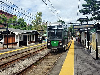
Longwood station is a light rail station on the MBTA Green Line D branch, located on Chapel Street in Brookline, Massachusetts, on the border with Boston, just north of Longwood Avenue. It serves the Longwood Medical Area, the Colleges of the Fenway, and residential areas of Brookline. The station opened with the rest of the line on July 4, 1959. After renovation work completed in 2009, Longwood station is accessible from both Chapel Street and Riverway Park.

<span class="mw-page-title-main">Boston and Albany Railroad</span> American railroad line (1867-1961)

The Boston and Albany Railroad was a railroad connecting Boston, Massachusetts to Albany, New York, later becoming part of the New York Central Railroad system, Conrail, and CSX Transportation. The line is currently used by CSX for freight. Passenger service is provided on the line by Amtrak, as part of their Lake Shore Limited service, and by the MBTA Commuter Rail system, which owns the section east of Worcester and operates it as its Framingham/Worcester Line.

<span class="mw-page-title-main">Reservoir station (MBTA)</span> Light rail station in Brookline, Massachusetts, US

Reservoir station is a light rail station on the MBTA Green Line D branch, located in Brookline, Massachusetts, adjacent to the Cleveland Circle area of Brighton. The station is adjacent to Reservoir Yard and Carhouse, with the Cleveland Circle terminus of the C branch just a block away. With a daily ridership of 3,395, Reservoir is the second-busiest surface stop on the D branch.

<span class="mw-page-title-main">Green Line D branch</span> Light rail line

The Green Line D branch is a light rail line in Boston, Brookline, Cambridge, Newton, and Somerville, Massachusetts, operating as part of the Massachusetts Bay Transportation Authority (MBTA) Green Line. The line runs on a grade separated surface right-of-way for 9 miles (14 km) from Riverside station to Fenway station. The line merges into the C branch tunnel west of Kenmore, then follows the Boylston Street subway and Tremont Street subway to North Station. It is the longest and busiest of the four Green Line branches. As of February 2023, service operates on 8 to 9-minute headways at weekday peak hours and 8 to 11-minute headways at other times, using 13 to 19 trains.

<span class="mw-page-title-main">Newton Lower Falls Branch</span> Former railway line in Massachusetts, US

The Newton Lower Falls Branch was a short branch of the Boston and Albany Railroad in Massachusetts. The approximately 1.2-mile (1.9 km) line ran between Riverside station in Newton and Lower Falls in Wellesley, with one intermediate station.

<span class="mw-page-title-main">Fenway station</span> Light rail station in Boston, Massachusetts, US

Fenway station is a light rail stop on the MBTA Green Line D branch, located under Park Drive near the Riverway in the Fenway–Kenmore neighborhood of Boston, Massachusetts. It opened along with the rest of the D branch on July 4, 1959, when trolleys replaced Highland branch commuter rail service. The station is fully accessible from Park Drive via the Landmark Center parking lot, as well as from Miner Street. Named after the Fenway parkway rather than Fenway Park, it is further from the stadium than Kenmore, though still used during events.

<span class="mw-page-title-main">Brookline Village station</span> Light rail station in Brookline, Massachusetts, US

Brookline Village station is a light rail station on the MBTA Green Line D branch, located in the Brookline Village neighborhood of Brookline, Massachusetts, United States. It was originally a commuter rail station on the Boston and Albany Railroad's Highland branch; it closed with the rest of the line in 1958 and reopened on July 4, 1959 as a light rail station. With 3,230 daily boardings, it is the third-busiest surface station on the D branch and the sixth-busiest surface station overall. Brookline Village station has raised platforms for accessibility with low-floor light rail vehicles.

<span class="mw-page-title-main">Needham Line</span> MBTA Commuter Rail line

The Needham Line is a branch of the MBTA Commuter Rail system, running west from downtown Boston, Massachusetts through Roxbury, Jamaica Plain, Roslindale, West Roxbury, and the town of Needham. The second-shortest line of the system at just 13.7 miles (22.0 km) long, it carried 4,881 daily riders in October 2022. Unlike the MBTA's eleven other commuter rail lines, the Needham Line is not a former intercity mainline; instead, it is composed of a former branch line, a short segment of one intercity line, and a 1906-built connector.

<span class="mw-page-title-main">Beaconsfield station (MBTA)</span> Light rail station in Brookline, Massachusetts, US

Beaconsfield is an MBTA light rail station in Brookline, Massachusetts. It serves the Green Line D branch. It is located off Dean Road and Beaconsfield Road just south of Beacon Street. Like the other stops on the line, it was a commuter rail station on the Boston and Albany Railroad's Highland branch until 1958, when the line was closed and converted to a branch of what is now the Green Line. The station reopened along with the rest of the line in 1959.

<span class="mw-page-title-main">Woodland station</span> Light rail station in Newton, Massachusetts, US

Woodland station is a light rail stop on the MBTA Green Line D branch, located off Washington Street (MA-16) between the Newton Lower Falls and Auburndale villages of Newton, Massachusetts, United States. It serves as access to the Newton-Wellesley Hospital, as well as a park and ride station for nearby Route 128.

<span class="mw-page-title-main">Lansdowne station (MBTA)</span> Railway station in Boston, Massachusetts, US

Lansdowne station is an MBTA Commuter Rail station in Boston, Massachusetts. It serves the Framingham/Worcester Line. Lansdowne is located next to the Massachusetts Turnpike in the Fenway–Kenmore neighborhood near Kenmore Square, below grade between Beacon Street and Brookline Avenue.

<span class="mw-page-title-main">Brookline Hills station</span> Light rail station in Brookline, Massachusetts, US

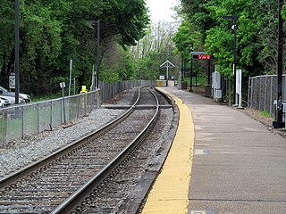
Brookline Hills station is a light rail station on the Massachusetts Bay Transportation Authority (MBTA) Green Line D branch in the Brookline Hills neighborhood of Brookline, Massachusetts. The station has two side platforms serving the line's two tracks. It was closed from April 2021 to January 2022 as part of adjacent construction on a Brookline High School building, which included renovations to make the station accessible.

<span class="mw-page-title-main">Needham Junction station</span>

Needham Junction station is an MBTA Commuter Rail station in Needham, Massachusetts. It serves the Needham Line. It is located on Junction Street near Chestnut Street in the southwestern part of Needham. It opened in 1906 when the New Haven Railroad built the Needham Cutoff to connect the Charles River Railroad to its main line. The station has a single side platform with an accessible mini-high platform serving the line's single track.

<span class="mw-page-title-main">Needham Center station</span> Railway station in Needham, Massachusetts, US

Needham Center station is a commuter rail station on the MBTA Commuter Rail Needham Line, located just north of Great Plain Avenue (MA-135) in downtown Needham, Massachusetts. The first station at Needham opened in 1853; it burned in 1887 and was replaced with a stone station, some of which is still in place. The station has one side platform with an accessible mini-high platform serving the line's single track.

<span class="mw-page-title-main">Needham Heights station</span> Railway station in Needham, MA

Needham Heights station is an MBTA Commuter Rail station in the Needham Heights neighborhood of Needham, Massachusetts. It is the terminus of the Needham Line. The station has one low-level side platform with a mini-high section for accessibility serving the single track of the Needham Branch.

<span class="mw-page-title-main">West Roxbury station</span>

West Roxbury station is an MBTA Commuter Rail station in Boston, Massachusetts, served by the Needham Line. It is located on an embankment above Lagrange Street in the West Roxbury neighborhood. The station is accessible with a short mini-high platform on the outbound end of the main platform.

<span class="mw-page-title-main">Auburndale station (MBTA)</span> Commuter rail station in Newton, Massachusetts

Auburndale station is an MBTA Commuter Rail station in Auburndale, Massachusetts. It serves the Framingham/Worcester Line. It is located next to the Massachusetts Turnpike near Lasell College. The modern station platform, built around 1961, replaced a highly acclaimed 1881 depot building designed by H. H. Richardson. A full renovation of the station for accessibility is planned.

<span class="mw-page-title-main">Wellesley Hills station</span> Rail station in Wellesley, Massachusetts, US

Wellesley Hills station is an MBTA Commuter Rail station in Wellesley, Massachusetts, United States. It serves the Framingham/Worcester Line. It is located off Washington Street (MA-16) in Wellesley, Massachusetts. Wellesley Hills has two low platforms serving the line's two tracks; it is not accessible. Designed in 1885 and completed in 1886, the station was the last of nine stations that H.H. Richardson designed for the Boston and Albany Railroad. It replaced a previous station, built in 1834 with the completion of the Boston and Worcester Railroad.

<span class="mw-page-title-main">Framingham station</span> MBTA and Amtrak railroad station in Framingham, Massachusetts.

Framingham station is a historic Boston and Albany Railroad station located in downtown Framingham, Massachusetts. Designed by noted American architect H. H. Richardson, it was one of the last of the railroad stations he designed in the northeastern United States to be built. The station, built in 1884–85, served as a major stop on the B&A Main Line as well as a hub for branch lines to Milford, Mansfield, Fitchburg, and Lowell. After years of deterioration, the station was listed on the National Register of Historic Places in 1975 as the Framingham Railroad Station, and restored a decade later.

The Charles River Railroad was a railroad in the U.S. state of Massachusetts. It ran from a connection with the end of the Charles River Branch Railroad in Dover to Bellingham through the current-day towns of Medfield, Millis, and Medway.

References