Hope is a village and civil parish in the Derbyshire Peak District, in England. The population at the 2011 Census was 864. It lies in the Hope Valley, at the point where Peakshole Water flows into the River Noe. To the north, Win Hill and Lose Hill stand either side of the Noe.

Bakewell is a market town and civil parish in the Derbyshire Dales district of Derbyshire, England, known for Bakewell pudding. It lies on the River Wye, 15 miles (23 km) south-west of Sheffield. It is the largest settlement and only town within the boundaries of the Peak District National Park. At the 2011 census, the population of the civil parish was 3,949. It was estimated at 3,695 in 2019. The town is close to the tourist attractions of Chatsworth House and Haddon Hall.

Heanor (/ˈhiːnə/) is a town in the Amber Valley district of Derbyshire, England. It lies 8 miles (13 km) north-east of Derby and forms, with the adjacent village of Loscoe, the civil parish and town council-administered area of Heanor and Loscoe, which had a population of 17,251 in the 2011 census.

Wirksworth is a market and industrial town and civil parish in the Derbyshire Dales district of Derbyshire, England. Its population of 4,904 in the 2021 Census was estimated at 5,220 in 2023. Wirksworth contains the source of the River Ecclesbourne. The town was granted a market charter by Edward I in 1306 and still holds a market on Tuesdays in the Memorial Gardens. The parish church of St Mary's is thought to date from 653. The town developed as a centre for lead mining and stone quarrying. Many lead mines were owned by the Gell family of nearby Hopton Hall.

Dronfield is a town in North East Derbyshire, England, which includes Dronfield Woodhouse and Coal Aston. It lies in the valley of the River Drone between Chesterfield and Sheffield. The Peak District National Park is three miles (4.8 km) to the west. The name comes from the Old English Dranfleld, probably meaning an open land infested with drone bees.

Monyash is a village and civil parish in the Peak District, Derbyshire, England, 5 miles (8 km) west of the market town Bakewell. It is centred on a village green 265 metres (869 ft) above sea level at the head of Lathkill Dale in the limestone area known as the White Peak. At the 2011 census, it had a population of 314. Tourism and farming are the predominant activities of the village. The area was once an important meeting place, a watering point for drovers’ animals at the intersection of several trade routes, and industrial centre supporting the local lead mining industry.

Tissington is a village and former civil parish, now in the parish of Tissington and Lea Hall, in the Derbyshire Dales district of Derbyshire, England. In 2001 the parish had a population of 158. The population "Tissington and Lea Hall" at the 2011 census was 159. It is part of the estate of Tissington Hall, owned by the FitzHerbert family since 1465. It is a popular tourist attraction, particularly during its well dressing week. It also gives its name to the Tissington Trail, a 13-mile (21 km) walk and cycle path which passes nearby. The Limestone Way, another long-distance path and bridleway, passes through the village itself.

Totley is a suburb on the extreme southwest of the city of Sheffield, in South Yorkshire, England. Lying within the historic county boundaries of Derbyshire, Totley was amalgamated into the city of Sheffield in 1933, and is today part of the Dore and Totley electoral ward in the city, though it remains close to the contemporary county boundary of Derbyshire. Totley had a population of 7,963 in 2011.

Kedleston is a village and civil parish in the Amber Valley district of Derbyshire, approximately 4 miles (6.4 km) north-west of Derby. Nearby places include Quarndon, Weston Underwood, Mugginton and Kirk Langley. The population at the 2011 Census was less than 100. Details are included in the civil parish of Mackworth, Amber Valley.

Ashford-in-the-Water is a village and civil parish in the Derbyshire Peak District, England. The village is on the River Wye, 2 miles (3 km) north-west of Bakewell. It is known for the quarrying of Ashford Black Marble, and for the maidens' garlands made to mark the deaths of virgins in the village until 1801. Some of these are preserved in the parish church. The civil parish population taken at the 2011 Census was 559.
Flagg is a small Peak District village and civil parish, set in the Derbyshire Dales, halfway between the small market town of Bakewell and the spa town of Buxton, in the area known as the White Peak. The population of the civil parish as taken at the 2011 Census was 192.
Foremark is a hamlet and civil parish in the South Derbyshire district of Derbyshire, England. It contains Foremarke Hall, a medieval manor house which now houses Repton Preparatory School; and part of Foremark Reservoir.

Clifton upon Teme is a village and civil parish in the Malvern Hills district in the county of Worcestershire, England. In 2021 the parish had a population of 871.

Smisby is an ancient manor, civil parish and small village in South Derbyshire, England. It is 4 miles (6.4 km) from Melbourne and near the Leicestershire border and the town of Ashby-de-la-Zouch. The village including the outlying farms and houses has a population just over 200 that occupies some 110 properties. The population at the 2011 Census had increased to 260.

Parwich is a village and parish in the Derbyshire Dales, 7 miles north of Ashbourne. In the 2011 census the population of the civil parish was 472.
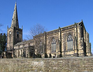
St John the Baptist’s Church, Dronfield is a Grade I listed parish church in the Church of England in Dronfield, Derbyshire.

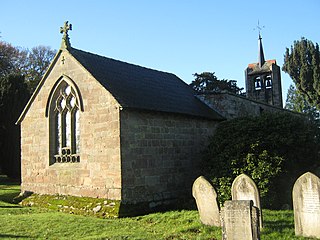
St Swithin's Church is a Grade II listed parish church in the Church of England in Holmesfield, Derbyshire.
Edlaston and Wyaston is a civil parish within the Derbyshire Dales district, in the county of Derbyshire, England. The parish includes the villages of Edlaston and Wyaston. In 2011 the parish had a population of 220, which increased to 241 in the census of 2021. It is 120 miles (190 km) north west of London, 11 miles (18 km) north west of the county city of Derby, and 2+1⁄2 miles (4 km) south of the market town of Ashbourne. Edlaston and Wyaston touches the parishes of Clifton and Compton, Osmaston, Rodsley, Shirley, Snelston and Yeaveley. There are seven listed buildings in Edlaston and Wyaston.
Highlow is a civil parish within the Derbyshire Dales district, in the county of Derbyshire, England. Largely rural, Highlow's population is reported with the population of neighbouring parishes for a total of 585 residents in 2011. It is 140 miles (230 km) north-west of London, 28 miles (45 km) north-west of the county city of Derby, and 7+1⁄2 miles (12.1 km) north of the nearest market town of Bakewell. Highlow is wholly within the Peak District national park, and shares a border with the parishes of Abney and Abney Grange, Eyam, Foolow, Grindleford, Hathersage as well as Offerton. There are nine listed buildings in Highlow.
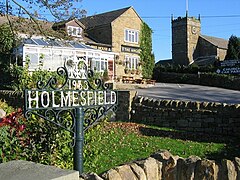
Holmesfield is a civil parish in the North East Derbyshire district of Derbyshire, England. The parish contains 41 listed buildings that are recorded in the National Heritage List for England. Of these, five are listed at Grade II*, the middle of the three grades, and the others are at Grade II, the lowest grade. The parish contains the village of Holmesfield, the hamlet of Cartledge, and the surrounding countryside and moorland. Most of the listed buildings are houses, cottages and associated structures, farmhouses, and farm buildings. The other listed buildings include two medieval crosses, a cross dated 1619, a church, public houses, a former toll house, a milepost, and two milestones.