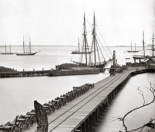
Hopewell is an independent city surrounded by Prince George County and the Appomattox River in the Commonwealth of Virginia. As of the 2010 census, the population was 22,591. The Bureau of Economic Analysis combines the city of Hopewell with Prince George County for statistical purposes.

The Hopewell tradition describes the common aspects of the Native American culture that flourished along rivers in the northeastern and midwestern United States from 100 BCE to 500 CE, in the Middle Woodland period. The Hopewell tradition was not a single culture or society, but a widely dispersed set of related populations. They were connected by a common network of trade routes, known as the Hopewell exchange system.

The Greater Richmond Region, the Richmond metropolitan area or Central Virginia, is a region and metropolitan area in the U.S. state of Virginia, centered on Richmond. The U.S. Office of Management and Budget (OMB) defines the area as the Richmond, VA Metropolitan Statistical Area, a Metropolitan Statistical Area (MSA) used by the U.S. Census Bureau and other entities. The OMB defines the area as comprising thirteen counties, including the principal cities of Richmond, Petersburg, Hopewell, and Colonial Heights. As of 2016, it had a population of 1,263,617, making it the 45th largest MSA in the country.

State Route 156 is a primary state highway in the U.S. state of Virginia. The state highway runs 57.38 miles (92.34 km) from U.S. Route 301 and SR 35 in Templeton north to US 360 Business in Mechanicsville. SR 156 follows a circuitous route through the eastern part of the Richmond–Petersburg metropolitan area. South of the James River, the state highway connects Templeton in Prince George County with Hopewell, which is directly served by SR 156 Business. SR 156 crosses the James River on the Benjamin Harrison Memorial Bridge and briefly passes through Charles City County. For most of its length in Henrico and Hanover, the state highway is a rural road that provides access to several units of Richmond National Battlefield Park. However, SR 156 provides access to Richmond International Airport, Interstate 64, and I-295 as it passes through the Richmond suburbs of Sandston and Highland Springs as a major highway.

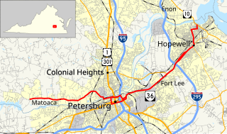
State Route 36 is a state highway in the U.S. state of Virginia. The state highway runs 16.70 miles (26.88 km) from SR 602 and SR 669 near Matoaca east to SR 10 in Hopewell. SR 36 is the main highway between Petersburg and Hopewell; within each independent city, the state highway follows a Byzantine path. The state highway connects those cities with Ettrick in southern Chesterfield County and Fort Lee and Petersburg National Battlefield in Prince George County.

The Tri-Cities of Virginia is an area in the Greater Richmond Region which includes the three independent cities of Petersburg, Colonial Heights, and Hopewell and portions of the adjoining counties of Chesterfield, Dinwiddie, and Prince George in south-central Virginia. Other unincorporated communities located in the Tri-Cities area include Ettrick, Fort Lee, and City Point, the latter formerly a historic incorporated town which was annexed to become part of the City of Hopewell.

White Hall is an unincorporated farming community in northern Frederick County, Virginia, established in the late 1810s and located near the crossroads of Apple Pie Ridge Road with Green Spring and White Hall Roads, astride Apple Pie Ridge.

Buildings, sites, districts, and objects in Virginia listed on the National Register of Historic Places:

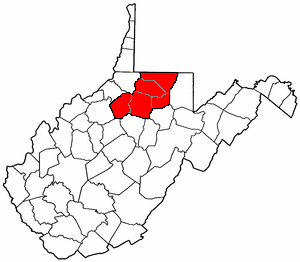
North Central West Virginia is a region of the U.S. State of West Virginia. The region's largest city is Morgantown.

State Route 106 is a primary state highway in the U.S. state of Virginia. The state highway runs 30.00 miles (48.28 km) from U.S. Route 460 and US 460 Business in Petersburg north to SR 249 in Talleysville. SR 106 connects Prince George County in the southern part of the Richmond–Petersburg metropolitan area with Charles City and New Kent counties on the Virginia Peninsula via the Benjamin Harrison Memorial Bridge over the James River.

Oregon Route 153 is an Oregon state highway running from OR 18 in Bellevue to OR 221 near Hopewell. OR 153 is known as the Bellevue-Hopewell Highway No. 153. It is 14.34 miles (23.08 km) long and runs east–west, entirely within Yamhill County.

Bowling Green Township is one of the twenty-five townships of Licking County, Ohio, United States. The 2000 census found 1,668 people in the township.
Riley Edward Ingram is an American politician. Since 1992 he has served in the Virginia House of Delegates, representing the 62nd district east of Richmond, made up of parts of Chesterfield, Henrico and Prince George Counties and the city of Hopewell. He is a member of the Republican Party.
Hopewell, West Virginia may refer to:

Hopewell is an unincorporated community in Barbour County, West Virginia, United States. It lies at an elevation of 1,388 feet.

Hopewell is an unincorporated community in Fayette County, West Virginia, United States. It lies at an elevation of 1480 feet.

Hopewell is an unincorporated community in Preston County, West Virginia, United States. It lies at an elevation of 1742 feet.
Hopewell is an unincorporated community in Pittsylvania County, Virginia, United States. It lies at an elevation of 853 feet.

The Armstrong culture were a Hopewell group in the Big Sandy River Valley of Northeastern Kentucky and Western West Virginia from 1 to 500 CE.


