
The Shan people, also known as the Dai or Tai Yai, are a Tai ethnic group of Southeast Asia. The Shan are the biggest minority of Burma (Myanmar) and primarily live in the Shan State of this country, but also inhabit parts of Mandalay Region, Kachin State, and Kayin State, and in adjacent regions of China, Laos, Assam and Thailand. Though no reliable census has been taken in Burma since 1935, the Shan are estimated to number 4–6 million, with CIA Factbook giving an estimate of five million spread throughout Myanmar which is about 10% of the overall Burmese population.
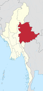
Shan State is a state of Myanmar. Shan State borders China (Yunnan) to the north, Laos to the east, and Thailand to the south, and five administrative divisions of Burma in the west. The largest of the 14 administrative divisions by land area, Shan State covers 155,800 km2, almost a quarter of the total area of Burma. The state gets its name from Burmese name for the Tai people: "Shan people". The Shan constitute the majority among several ethnic groups that inhabit the area. Shan is largely rural, with only three cities of significant size: Lashio, Kengtung, and the capital, Taunggyi. Taunggyi is 150.7 km northeast of the nation's capital Naypyitaw.

Myanmar is divided into twenty-one administrative subdivisions, which include states, regions, union territory, self-administered zones and self-administered division. Following is the table of government subdivisions and its organizational structure based on different states, regions, zones, division and the union territory:

Thaungdut is a village on the Chindwin River in Homalin Township in Hkamti District in the Sagaing Region of northwestern Burma. It is located next to Chaunggan.
Mong Kung, Mongkung, Mongkaung or Möngkung is a town in Shan State some 100 kilometres east of Mandalay. It is the capital of Mong Kung Township, Myanmar.
Articles related to Myanmar include:
Thabeikkyin Township is a township of Pyin Oo Lwin District in the Mandalay Region of Burma. It is the northernmost township in Pyin Oo Lwin District and, although it primarily lies on the east bank of the Irrawaddy, it has a small enclave on the western bank extending as far as the village of Gagalaw, near the town of Baw in Katha District, Sagaing Region. On the south it borders Singu Township, on the east, Mogote Township and further north Shan State, while it abuts Tigyaing Township of Sagaing Region to the north.
Mohnyin Township is a township of Mohnyin District in the Kachin State of Burma (Myanmar). The principal town and administrative centre is Mohnyin. Jade and gem quality kyanite are produced in Mohnyin Township, as well as amber, gold, asafoetida, and jasper. Indawgyi Lake Wildlife Sanctuary is located in the central north of the township.

Taunggyi Township is a township of Taunggyi District in the Shan State of Myanmar. The principal town is Taunggyi.

Nyaungshwe Township is a township of Taunggyi District in Shan State, Myanmar. It is located south of Sakangyi and south-west of Taunggyi. The principal town is Nyaungshwe.
Langhko Township or Langkho Township is a township of Langhko District in the Shan State of Burma.

Nawnghkio Township is a township of Kyaukme District in the Shan State of eastern Myanmar. The principal town and administrative seat is Nawnghkio. The name 'Nawnghkio' was started to call after a camp near a green lake. The lake is located in the west of 'Haw Taw Monastery' of today's Nawnghkio.
Mong Pan Township is a township of Loilen District in the Shan State of Myanmar. The capital town is Mong Pan or Möngpan, formerly the residence of the Sawbwa.
Hopin is a town in Mohnyin Township, Kachin State, in north-east Myanmar. It is situated on the main Mandalay – Myitkyina railway line, 745 miles north from Yangon. It is on the road between Mohnyin and Mogaung where the road to Ywathit and Indawgyi Lake takes off. It is 27 miles by road from Indawgyi Lake and 60 miles by road from Sinbo which is located on the west bank of the Ayeyarwady River.
Momeik, also known as Mong Mit in Shan, is a town situated on the Shweli River in northern Shan State of Myanmar (Burma).
Htigyaing Township or Tigyaing Township is a township of Katha District in eastern Sagaing Region, in northern Myanmar. It lies on the border with the Shan State of Myanmar. The administrative seat is at Htigyaing.
Ywathit is a town in Mohnyin Township in Kachin State of Myanmar. It is on the road between Hopin and Indawgyi Lake.

Hkamti Township or Khamti Township is a township in Hkamti District in the Sagaing Region of Burma (Myanmar). The principal town is Hkamti. As of 2014 the township had a population of 47,658 people and covered an area of 8,174 square kilometres (3,156 sq mi). The township is dominated by the Chindwin River and its tributaries and thickly forested areas. Nearly half the active working population are employed in agriculture, forestry or fishing. The township is a producer of rice, and has reserves of gold and jade being mined.

Pinlaung is a town 1,510 metres (4,950 ft) above sea level and seat of Pinlaung Township, in the Pa-O Self-Administered Zone of Shan State of eastern-central Burma. It lies along National Road 54, north-west by road from Loikaw. Running through the city center is a rail line connecting Loikaw to Kalaw, two major tourist towns in the area.
Homein also known as Homong, Homöng, Ho Mong and Wān Ho-möng, is a village in Langkho Township, Langkho District, southern Shan State, Myanmar (Burma).


