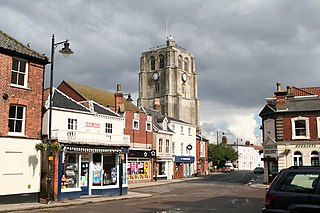
Southwold is a seaside town and civil parish on the North Sea, in the East Suffolk district, in the county of Suffolk, England. It lies at the mouth of the River Blyth in the Suffolk Coast and Heaths Area of Outstanding Natural Beauty, 11 miles (18 km) south of Lowestoft, 29 miles (47 km) north-east of Ipswich and 97 miles (156 km) north-east of London, within the parliamentary constituency of Suffolk Coastal. At the 2021 Census, the population was 950.
Beccles is a market town and civil parish in the English county of Suffolk. The town on the A145 and A12 roads, situated 16 miles (26 km) south-east of Norwich and 33 miles (53 km) north-northeast of Ipswich. Nearby towns include Lowestoft to the east and Great Yarmouth to the north-east. The town lies on the River Waveney on the edge of The Broads National Park.
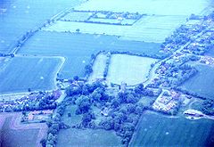
Walberswick is a village and civil parish on the Suffolk coast in England. It is at the mouth of the River Blyth on the south side of the river. The town of Southwold lies to the north of the river and is the nearest town to Walberswick, around 1 mile (1.6 km) away. Walberswick is around 11 miles (18 km) south of Lowestoft on the North Sea coast. It is 7 miles (11 km) east of Halesworth and 28 miles (45 km) northeast of the county town of Ipswich.

Yoxford is a village in East Suffolk, England, close to the Heritage Coast, Minsmere Reserve (RSPB), Aldeburgh and Southwold. It is known for its antique shops and for providing the setting for a Britten opera.
Halesworth is a market town, civil parish and electoral ward in north-eastern Suffolk, England. The population stood at 4,726 in the 2011 Census. It lies 15 miles (24 km) south-west of Lowestoft, on a tributary of the River Blyth, nine miles upstream from Southwold. The town is served by Halesworth railway station on the Ipswich–Lowestoft East Suffolk Line. It is twinned with Bouchain in France and Eitorf in Germany. Nearby villages include Cratfield, Wissett, Chediston, Walpole, Blyford, Linstead Parva, Wenhaston, Thorington, Spexhall, Bramfield, Huntingfield, Cookley and Holton.

The Mid-Suffolk Light Railway (MSLR) was a standard gauge railway intended to open up an agricultural area of central Suffolk; it took advantage of the reduced construction cost enabled by the Light Railways Act 1896. It was launched with considerable enthusiasm by local interests, and was to build a 50-mile (80 km) network, but actual share subscription was weak, and the company over-reached its available financial resources. It opened 19 miles (31 km) of route from Haughley to Laxfield in 1904 to goods traffic only, and income was poor, further worsening the company's financial situation.
Martlesham is a village in Suffolk, England about two miles (3 km) south-west of Woodbridge and 6 miles (9.7 km) east of Ipswich. It is often referred to as "old Martlesham" by locals in order to distinguish this old village from the much more recent Martlesham Heath development (1 km) to the south, although both form a single administrative parish. Also at Martlesham Heath is BT's Research and Development Centre, now called Adastral Park.

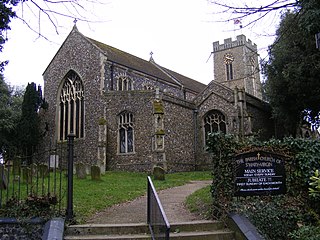
Blythburgh is a village and civil parish in the East Suffolk district of the English county of Suffolk. It is 4 miles (6.4 km) west of Southwold and 5 miles (8.0 km) south-east of Halesworth and lies on the River Blyth. The A12 road runs through the village which is split either side of the road. At the 2011 census the population of the parish was 297. The parish includes the hamlets of Bulcamp and Hinton.

Worlingham is a village and civil parish in the East Suffolk district of the English county of Suffolk. It is about 1.3 miles (2.1 km) east of Beccles, with the two places effectively joined to form one urban area. At the 2011 census it had a population of 3,745; the combined population of Beccles and Worlingham is 13,868. The parish has increased in population in recent years due to the development of suburban housing areas within the built up area, going up by over 13% between the 2001 and 2011 censuses.

Covehithe is a village and civil parish in the East Suffolk district of the English county of Suffolk. It lies on the North Sea coast around 4 miles (6.4 km) north of Southwold and 7 miles (11 km) south of Lowestoft. Neighbouring settlements include Benacre, South Cove and Frostenden.
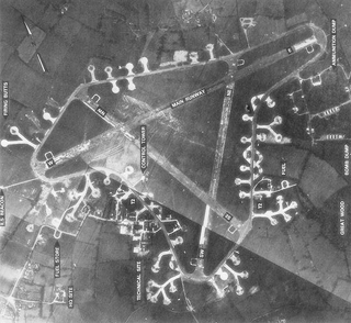
Royal Air Force Framlingham or more simply RAF Framlingham is a former Royal Air Force station located 3 miles (4.8 km) southeast of Framlingham, Suffolk, England.

The Waveney Valley line was a branch line running from Tivetshall in Norfolk to Beccles in Suffolk connecting the Great Eastern Main Line at Tivetshall with the East Suffolk line at Beccles. It provided services to Norwich, Great Yarmouth, Lowestoft, Ipswich and many other towns in Suffolk with additional services to London. It was named after the River Waveney which follows a similar route.

Monk Soham is a village in Suffolk, eastern England, four miles (6.4 km) northeast of Debenham and six miles (10 km) northwest of Framlingham. The neighbouring villages are Bedfield, Ashfield cum Thorpe, Kenton and Bedingfield. The nearest primary school is in Bedfield. There are secondary schools in Framlingham, Debenham and Woodbridge.

Denham is a village and civil parish in northern Suffolk. Located approximately 3 miles east of Eye, it is within the district of Mid Suffolk. It shares its name with Denham, another Suffolk village.
Haughley is a village and civil parish in the English county of Suffolk, in the Mid Suffolk District. The village is located 2 miles (3.2 km) northwest of the town of Stowmarket, overlooking the Gipping valley, next to the A14 corridor. The population recorded in 2011 was 1,638. Mentioned in the Domesday Book, it was the site of a castle, a church on the pilgrim's route to Bury St Edmunds Abbey, and a market. Adjacent farms on the north side of the village were also home to one of the first studies of organic farming and the first headquarters of the Soil Association.

Haughley railway station was located in Haughley, Suffolk on the Great Eastern Main Line between Liverpool Street Station and Norwich. It opened on 2 July 1849 named Haughley Junction and was a replacement for a station named Haughley Road which had been in service from 1846 to 1849 at location TM 02981 63319 on the line to Elmswell.

Kenton is a village and civil parish in the Mid Suffolk district of Suffolk in eastern England. Located 1.9 miles to the north-east of Debenham, in 2005 its population was 170. The parish was formerly an exclave of the Loes Hundred one of the Hundreds of Suffolk.

Redlingfield is a village and civil parish in the Mid Suffolk district of Suffolk in eastern England. Located around six miles south-east of Diss, in 2011 its population was 144, according to the 2011 census. Redlingfield Priory was found here from 1120 until it was disbanded during the Dissolution of the Monasteries, in which "the priory was surrendered on 10 February 1536-7".
The Eye Branch was a two miles 72 chains long single track branch railway line in Suffolk, England that ran from Mellis railway station on the Great Eastern Main Line to Eye via one intermediate station, Yaxley Halt. It was the shortest railway branch line in East Anglia to enjoy a regular passenger service.