Hurley Lock

Last updated

Hurley Lock
HurleyLock01.JPG
Hurley Lock and islands from upstream
Hurley Lock
Waterway River Thames
County Berkshire
Maintained by Environment Agency
OperationHydraulic
First built1773
Latest built1785
Length39.82 m (130 ft 8 in) [1]
Width6.07 m (19 ft 11 in) [1]
Fall1.05 m (3 ft 5 in) [1]
Above sea level96'
Distance to
Teddington Lock
40 miles
Hurley Lock
BSicon uSTR.svg
River Thames
BSicon uFABZgl+l.svg
BSicon uSTRq.svg
BSicon uSTR+r.svg
BSicon uFGATEu.svg
BSicon uSTR.svg
Hambleden Lock
BSicon ueABZg+l.svg
BSicon uexFABZq+lr.svg
BSicon uWEIRl.svg
weir
BSicon uSTR.svg
BSicon uexSTR.svg
BSicon ueMILL.svg
Site of mill
BSicon uSTR.svg
BSicon uddSTRr.svg
BSicon uddSTRl.svg
moorings
BSicon uFABZgl+l.svg
BSicon uABZqr.svg
BSicon uSTRr.svg
BSicon uexnSTRq.svg
Hamble Brook
BSicon uxISLAND.svg
Magpie Island
BSicon uSTR.svg
BSicon uxISLAND.svg
Black Boy Islands
BSicon uISLAND.svg
BSicon uWEIRr.svg
BSicon uCANOE.svg
BSicon uexSTRq.svg
BSicon uSTR+r.svg
Kayaking
BSicon uWEIRr.svg
BSicon uexSTR+r.svg
BSicon uSTR.svg
weir
BSicon uSKRZ-Eu.svg
BSicon uSTR.svg
BSicon uSTR.svg
Upper Towpath footbridge
BSicon uSTR+l.svg
BSicon uABZgr.svg
BSicon uSTR.svg
BSicon uISLAND.svg
BSicon uSTR.svg
BSicon uFGATEu.svg
BSicon uSTR.svg
BSicon uSTR.svg
Hurley Lock
BSicon ueMILL.svg
BSicon uSTR.svg
BSicon uSTR.svg
BSicon uSTR.svg
Site of mill
BSicon uSTRl.svg
BSicon uABZg+r.svg
BSicon uSTRl.svg
BSicon uFABZgr+r.svg
BSicon uSKRZ-Eu.svg
BSicon uSTR.svg
Lower Towpath footbridge
BSicon uFABZgl+l.svg
BSicon uSTRq.svg
BSicon uSTRr.svg
BSicon uSTR.svg
River Thames

Hurley Lock is a lock and weir on the River Thames in England, situated in a clump of wooded islands close to the village of Hurley, Berkshire. The lock was first built by the Thames Navigation Commissioners in 1773.

Contents

There are several weirs between the islands but the main weir is upstream between the topmost island and the Buckinghamshire bank. The weir is popular with kayakers whenever conditions are favourable, and it is very busy at weekends.

History

There was a Flash lock in the weir here, referred to in the 16th and 17th century as "New Lock". The pound lock was opened in 1773, being the fifth downstream of the eight original locks built after the 1770 navigation act. It was constructed of fir wood, and like the other locks, where the fir was subsequently replaced by oak, it was in decay and in need of repair in 1780 and 1785. On the latter occasion the owner of the flash lock was instructed to keep the flash lock in good repair for use by barges. Further repair was made in 1791, and in 1910 it still had timber sides. [2] It has since been replaced by masonry.

The timber weir winch, looking like a capstan and which was used to pull boats through the Flash Lock, is still at the lock.

Access to the lock

The lock and weir are easily reached by a short footpath from the free car park, which is at the end of Hurley High Street in the village of Hurley on the south bank of the river.

Reach above the lock

Lock cut above the lock HurleyLock03.JPG
Lock cut above the lock

A short way upstream on the Buckinghamshire bank is Medmenham Abbey home of the notorious Hell Fire Club. The river winds through open country with the paired Frog Mill Ait and Black Boy Island on a sharp bend in the river. Magpie Island is close to Culham Court on the way to Hambleden and Hambleden Lock.

Thames Path

The Thames Path remains on the Berkshire side and deviates away from the river to the village of Aston, Berkshire, before returning and continuing to Hambledon Lock.

Kayaking

Playboating at Hurley Weir on 2 gates Spargo frontsurf kayak playboating2006.jpg
Playboating at Hurley Weir on 2 gates

Hurley is an active freestyle kayaking centre because of the favourable size and shape of the wave. The gates – those which are open – generate a standing wave. Hurley also hosts an annual rodeo competition, the Hurley Classic.

Access

Two paths, one on either side of the car park, lead to the river and kayakers can put-in on a flat stretch immediately as they arrive at the river, from the car park side. To reach the wave they must paddle upstream (left) and the weir will appear on the right. The first weir should be ignored, as it is un-runnable. Hurley Weir's steps can be run, but will wear the hull of a kayak, and so is advisable to get out at the island where the weir steps, start and put in at the shingle "beach" below.

Gates

Hurley weir with all 4 gates open Hurley4gatesholes.jpg
Hurley weir with all 4 gates open
Hurley weir on 4 gates. Looking Downstream Hurley4gatesdownstream.jpg
Hurley weir on 4 gates. Looking Downstream
Hurley Lock head gates HurleyLock02.JPG
Hurley Lock head gates
Hurley Lock with the tail gates open Hurley Lock (Nancy).JPG
Hurley Lock with the tail gates open

The four main weir gates are opened and closed to control the river levels. The number of opened gates will also determine the nature of the wave/waves, and the suitability/difficulty level for kayakers:

Note: at certain levels, the wave train often "goes left" and turns the eddy in a large spinning mass. This has the effect of constantly pushing people who are queuing in the eddy into the main current.

Water levels

Usually more rainfall means more gates will be open, but this also depends upon the levels at weirs upstream, and as such it can be difficult to predict.

For the weir to form a good wave for kayakers, it generally needs to be late autumn, winter or early spring. Hurley is known to work during the summer, but for short periods of time. 9 months is the average consistent period of use. During the winter, a vague rule of thumb is 10 mm of rain is needed to open a gate. In the summer 15 mm may be required, and persistent rain is needed to keep levels up, due to ground levels of water being lower.

Literature and the Media

Jerome K Jerome wrote [I] often thought I could stay a month without having sufficient time to drink in all the beauty of the scene.

See also

Next lock upstream River Thames Next lock downstream
Hambleden Lock
5.89 km (3.66 mi) [3]
Hurley Lock
Grid reference: SU827842
Temple Lock
1.03 km (0.64 mi) [3]

51°33′04″N0°48′32″W / 51.5512°N 0.808961°W / 51.5512; -0.808961

Related Research Articles

<span class="mw-page-title-main">Locks and weirs on the River Thames</span>

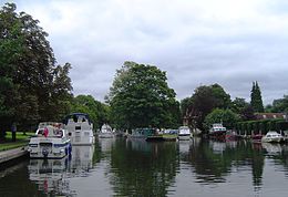
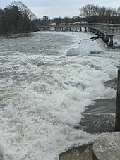
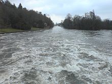
The English River Thames is navigable from Cricklade or Lechlade to the sea, and this part of the river falls 71 meters (234 feet). There are 45 locks on the river, each with one or more adjacent weirs. These lock and weir combinations are used for controlling the flow of water down the river, most notably when there is a risk of flooding, and provide for navigation above the tideway.

<span class="mw-page-title-main">Teddington Lock</span> Series of locks on the River Thames in London

Teddington Lock is a complex of three locks and a weir on the River Thames between Ham and Teddington in the London Borough of Richmond upon Thames, England. Historically in Middlesex, it was first built in 1810.

<span class="mw-page-title-main">Caversham Lock</span> Lock and weir on the River Thames in Berkshire, England

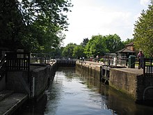
Caversham Lock is a lock and main weir on the River Thames in England at Reading, Berkshire. Both the lock and main weir are connected to De Bohun Island. The Thames Navigation Commissioners built the original lock in 1778. Additional sluices north of View Island and Heron Island form the whole weir complex. A footbridge, known as The Clappers, passes over the weir and all three islands to connect Lower Caversham to Reading.

<span class="mw-page-title-main">Marsh Lock</span> Lock and weir on the River Thames in Berkshire, England

Marsh Lock is a lock and weir situated on the River Thames in England, about 1 mile upstream of Henley Bridge in Henley-on-Thames, Oxfordshire. The lock is close to the Berkshire bank, but accessed from the Oxfordshire side via two long walkways, the downstream one being near Mill Meadows. The first pound lock was built by the Thames Navigation Commission in 1773.

<span class="mw-page-title-main">Sonning Lock</span> Lock and weir on the River Thames in Berkshire, England

Sonning Lock is a lock and associated weir situated on the River Thames at the village of Sonning near Reading, Berkshire, England. The first lock was built by the Thames Navigation Commission in 1773 and it has been rebuilt three times since then. There is a weir a little upstream at the top of the island where Sonning Backwater separates from the main course of the river.

<span class="mw-page-title-main">Bray Lock</span> Lock and weir on the River Thames in Buckinghamshire, England

Bray Lock is a lock and weir on the River Thames in England near Bray and Dorney Reach, and is just above the M4 Bridge across the Thames. The lock is on the Buckinghamshire side of the river on the opposite bank from Bray itself and Maidenhead which are in Berkshire. Here, the county line stands roughly halfway between the lock and the opposite bank, following the course of the Thames itself. The pound lock was built by the Thames Navigation Commission relatively late, in 1845. The lock keeper's cottage is on an island between the lock and the weir.

<span class="mw-page-title-main">Mapledurham Lock</span> Lock and weir on the River Thames in Berkshire, England

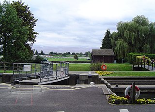
Mapledurham Lock is a lock and weir situated on the River Thames in England, about 4 miles upstream of Reading. The lock was first built in 1777 by the Thames Navigation Commissioners and the present lock dates from 1908.

<span class="mw-page-title-main">Whitchurch Lock</span> Lock and weir on the River Thames in Oxfordshire, England

Whitchurch Lock is a lock and weir on the River Thames in England. It is a pound lock, built by the Thames Navigation Commissioners in 1787. It is on an island near the Oxfordshire village of Whitchurch-on-Thames and is accessible only by boat.

<span class="mw-page-title-main">Shiplake Lock</span> Lock on the River Thames in Oxfordshire, England

Shiplake Lock is a lock and weir situated on the River Thames in England between the villages of Shiplake and Lower Shiplake, Oxfordshire. It is just above the points where the River Loddon joins the Thames and Shiplake Railway Bridge crosses the river. The first pound lock was built by the Thames Navigation Commission in 1773.

<span class="mw-page-title-main">Goring Lock</span> Lock and weir on the River Thames in Oxfordshire, England

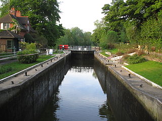
Goring Lock is a lock and weir situated on the River Thames in England at the Goring Gap in the Chiltern Hills. The lock is located on the Oxfordshire bank at Goring-On-Thames, with Streatley, Berkshire on the opposite side of the river. It is just upstream of Goring and Streatley Bridge. The lock was first built in 1787 by the Thames Navigation Commissioners

<span class="mw-page-title-main">Cookham Lock</span> Lock and weirs on the River Thames in Berkshire, England

Cookham Lock is a lock with weirs situated on the River Thames near Cookham, Berkshire, about a half-mile downstream of Cookham Bridge. The lock is set in a lock cut which is one of four streams here and it is surrounded by woods. On one side is Sashes Island and on the other is Mill Island connected to Formosa Island, the largest on the non-tidal Thames.

<span class="mw-page-title-main">Hambleden Lock</span> Lock on the River Thames in Berkshire, England

Hambleden Lock is a lock with a long weir situated on the River Thames in England, about 2 miles downstream of Henley Bridge. The lock is on the Berkshire bank between Aston and Remenham. Built by the Thames Navigation Commission in 1773, the lock is named after the village of Hambleden, a mile (1.5 km) to the north.

<span class="mw-page-title-main">Boulter's Lock</span> Lock and weir on the River Thames, England

Boulter's Lock is a lock and weir on the River Thames in England north-east of Maidenhead town centre, Berkshire. The present 1912-built lock replaces those at this point of the river to the immediate east dating from the late 16th century and that of 1772 built by the Thames Navigation Commission. The lock is on the western side of the north-south flowing reach between the A4094 Maidenhead to Cookham road and Ray Mill Island. The name is variably used for the immediate surrounding area.

<span class="mw-page-title-main">Shepperton Lock</span> Lock on the River Thames in Surrey, England

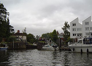
Shepperton Lock is a lock on the River Thames, in England by the left bank at Shepperton, Surrey. It is across the river from Weybridge which is nearby linked by a passenger ferry.

<span class="mw-page-title-main">Flash lock</span> Gate in the flow of a river which could be opened to allow boats through

A flash lock is a type of lock for river or canal transport.

<span class="mw-page-title-main">Temple Lock</span> Lock and weir on the River Thames in Buckinghamshire, England

Temple Lock is a lock and weir situated on the Buckinghamshire bank of the River Thames near Temple Mill Island opposite Temple Meadows and not far from Hurley, Berkshire. It was first built by the Thames Navigation Commissioners in 1773.

<span class="mw-page-title-main">Marlow Lock</span> Lock and weir on the River Thames in Buckinghamshire, England

Marlow Lock is a lock and weir situated on the River Thames in the town of Marlow, Buckinghamshire, England, about 300m downstream of Marlow Bridge. The first pound lock was built by the Thames Navigation Commission in 1773.

<span class="mw-page-title-main">Sunbury Lock</span> Lock on the River Thames in Surrey, England

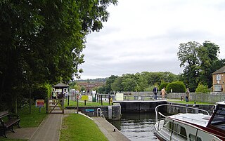
Sunbury Lock is a lock complex of the River Thames in England near Walton-on-Thames in north-west Surrey, the third lowest of forty four on the non-tidal reaches. The complex adjoins the right, southern bank about 12 mile (0.80 km) downstream of the Weir Hotel.

<span class="mw-page-title-main">Boveney Lock</span> Lock on the River Thames in Buckinghamshire, England

Boveney Lock is a lock on the River Thames situated on the Buckinghamshire bank opposite the Windsor Racecourse and close to Eton Wick. Boveney is a village a little way upstream on the same side. The lock was first built in 1838 by the Thames Navigation Commission. The lock was rebuilt in 1898 closer to the Buckinghamshire bank, and a set of boat rollers were installed on the old site.

<span class="mw-page-title-main">Buscot Lock</span> Lock on the River Thames in Oxfordshire, England

Buscot Lock is a lock on the River Thames in England, near the village of Buscot, Oxfordshire.

References

  1. 1 2 3 "Environment Agency Dimensions of locks on the River Thames". web page. Environmental Agency. 8 November 2012. Retrieved 17 November 2012. Dimensions given in metres
  2. Fred. S. Thacker The Thames Highway: Volume II Locks and Weirs 1920 – republished 1968 David & Charles
  3. 1 2 "Environment Agency Distances between locks on the River Thames". web page. Environmental Agency. 19 November 2012. Retrieved 21 November 2012. Distances given in km