Interior Low Plateaus

Last updated
Interior Low Plateaus
Hoosier National Forest.png
Interior Low Plateaus.png
Ecology
Biome Temperate broadleaf and mixed forests
Borders
Bird species203 [1]
Mammal species69 [1]
Geography
Area296,000 km2 (114,000 sq mi)
Country United States
States
Conservation
Habitat loss46.522% [1]
Protected7.01% [1]

The Interior Low Plateaus are a physiographic region in eastern United States. It consists of a diverse landscape that extends from north Alabama across central Tennessee and Kentucky into southern Illinois, Indiana, and Ohio. Its natural communities are a matrix of temperate forests, woodlands, and prairies.

Contents

Setting

This is a region of rolling plains and eroded plateaus, with a humid subtropical climate in the south and humid continental climate in the north. It is notable for its extensive karst limestone, which comprise the caves at Mammoth Cave National Park. This region includes a portion of what the U.S. Forest service calls the "Central Hardwood Forest". [2]

The region extends from southern Ohio, Indiana and Illinois through Tennessee and central Kentucky and into northern Alabama. Nearly 65% of Kentucky's territory is within the Interior Low Plateaus region, which encompasses an area from the western Appalachian Plateaus to the Tennessee River. It includes the Kentucky Bluegrass and Knobs regions, the Highland Rim and the Shawnee Hills. [3]

Geology

The underlying bedrock of the Interior Low Plateaus consists of sedimentary rocks such as limestone, sandstone, and shale. These date from the Ordovician period in the Nashville Basin and Bluegrass region, up to the Carboniferous Period in the Shawnee Hills. [4] The Interior Low Plateaus lie at the southern edge of the glacial boundary. Unlike the till plain to the north, the underlying bedrock is generally close to the surface, and the topography of an area depends on how resistant the underlying bedrock is to erosion. More resistant sandstones have resulted in hillier areas such as the Norman Upland and Crawford Upland in Southern Indiana, while softer limestones have already eroded down to gently rolling plains, like the Scottsburg Lowlands and Wabash Lowlands of southeast and southwest Indiana. The hillier parts of the Interior Low Plateaus are not mountain ranges, but dissected plateaus.[ citation needed ]

Natural Communities

The natural communities in this region are a matrix of forest, woodlands, and prairie. Today, much of the open prairie and savanna communities have been lost due to fire suppression and agriculture. However, oak-hickory woodlands remain relatively common, and mesic forest is abundant along riparian areas.[ citation needed ]

Woodlands

Oak-hickory woodland is the most common natural community in the Interior Low Plateaus. It is the dominant natural community for many areas of rolling hills, including the Western Highland Rim, Shawnee Hills, and Outer Bluegrass. These woodlands represent an intermediate state between a forest and a savanna.[ citation needed ]

Common trees in this community include post oak ( Quercus stellata ), white oak ( Quercus alba ), southern red oak ( Quercus falcata ), black oak ( Quercus velutina ), and pignut hickory ( Carya glabra ). In more calcareous areas, common woodland trees include Shumard oak ( Quercus shumardii ), Chinquapin oak ( Quercus muhlenbergii ), and Carolina shagbark ( Carya carolinae-septentrionalis ). In more acidic dry woodlands there are stands of chestnut oak ( Quercus montana ) and Virginia pine ( Pinus virginiana ). In swampy fragipan flats, woodlands consist of willow oak ( Quercus phellos ), overcup oak ( Quercus lyrata ), pin oak ( Quercus palustris ), sweetgum ( Liquidambar styraciflua ), and blackgum ( Nyssa sylvatica ). [4] The woodlands in this region contain a rich sun-loving herbaceous layer, with many species of goldenrod ( Solidago ), sunflower ( Helianthus ), and aster ( Symphyotrichum ).

Prairie and Savanna

The flat surfaces of the Interior Low Plateaus historically contained extensive areas of open prairie. This community was concentrated in the areas of the Mitchell Plain and Pennyroyal Plain with smaller areas of prairie in the Nashville Basin and Highland Rim. Early settlers describe these areas as nearly treeless expanses, containing Greater prairie chicken and herds of Bison. [5] Today, some prairie remains in areas that are managed by controlled burns, or other forms of tree removal such as powerline and roadside clearings. [6]

Dry prairies are the most common remnant in this region, due to their unsuitability for agriculture and resistance to succession. They are dominated by Schizachyrium scoparium (little bluestem) and Aristida purpurascens (three-awn grass). Mesic prairies are rarer, and are dominated by very tall grasses such as Indian grass ( Sorghastrum nutans ), big bluestem ( Andropogon gerardi ), and plume grass ( Erianthus alopecuroides ). Wet prairies are the rarest and most poorly-documented grassland type in this region. The few existing remnants have species such as gamagrass ( Tripsacum dactyloides ), prairie cordgrass ( Spartina pectinata ), and many rushes ( Juncus ) and sedges ( Carex ). Significant prairie remnants now remain at Ft. Campbell and Arnold Air Force Base, as well as in a few small nature preserves. [7] Blackjack oak ( Quercus marilandica ) was reportedly one of the few trees that could occasionally survive the annual wildfires in the prairies.

Forests

Closed-canopy forests in this region are also naturally found in many areas, such as riparian zones, river bottoms, and dissected terrain.

Mesic forests are often found in narrow stream gorges. These forests have a particularly rich diversity in spring wildflowers. They are dominated by sugar maple ( Acer saccharum ), beech ( Fagus grandifolia ), basswood ( Tilia americana ), northern red oak ( Quercus rubra ), and tuliptree ( Liriodendron tulipifera ). In the Eastern Highland Rim, at the edge of the Cumberland Plateau, these forests develop a more Appalachian character, and contain species such as eastern hemlock ( Tsuga canadensis ), yellow buckeye ( Aesculus flava ), and cucumber magnolia ( Magnolia tripetala ). [6] [4] Acidic sandstone cove forests in the Shawnee Hills also contain more typically Appalachian species such as yellow birch ( Betula alleghaniensis ) and umbrella magnolia ( Magnolia tripetala ). [8]

Floodplain forests in the Interior Low Plateau remain relatively common, although many areas have been converted to agriculture. These forests are dominated by sugarberry ( Celtis laevigata ), boxelder ( Acer negundo ), silver maple ( Acer saccharinum ), and sycamore ( Platanus occidentalis ). [4]

Forests were particularly common in the uplands of the Inner Bluegrass region of Kentucky, which has naturally mesic conditions. These forests were dominated by sugar maple ( Acer saccharum ), bitternut hickory ( Carya cordiformis ), Ohio buckleye ( Aesculus glabra ), blue ash ( Fraxinus quadrangulata ), and chinquapin oak ( Quercus muhlenbergii ). This community is now quite rare in the Inner Bluegrass due to logging by early European settlers. Its destruction was so rapid and complete, that mid-20th century ecologists mistook the successional state of the Bluegrass as its natural condition. Sun-loving species such as hackberry ( Celtis occidentalis ), black cherry ( Prunus serotina ), black walnut ( Juglans nigra ), and white ash ( Fraxinus americana ) now dominate much of the Bluegrass region. [9] [10]

Barrens and Glades

Barrens are open treeless areas on slopes, often with shallow soil. These are found sporadically in the Outer Bluegrass, Inner Nashville Basin, Shawnee Hills, and in parts of the Highland Rim. It is unclear whether these communities rely on fire for their openness, or are maintained by soil conditions alone. [4] They are usually dominated by short grasses such as little bluestem ( Schizachyrium scoparium ), and large showy forbs such as prairie dock ( Silphium terebinthinaceum ) and blazing star ( Liatris ). Barrens are particularity abundant and well-preserved in the area of Adams County, Ohio, which includes Adams Lake Prairie, Lynx Prairie, Chaparral Prairie, and others.[ citation needed ]

Glades are areas of flat rock exposures of bedrock. In the Nashville Basin, glades are most often found in areas that were a matrix of barren and woodland communities. [11] Although historically with a more open grassland border, many are now surrounded by dense thickets of redcedar ( Juniperus virginiana ) and redbud ( Cercis canadensis ). Glades are most common the Nashville Basin, although there are rare examples found in the Mitchell Plain, Pennyroyal Plain and Outer Bluegrass. Glades have a flora adapted to extreme dry conditions in the summer, and standing water in the spring. [6] The glades of the Nashville Basin and Moulton Valley are considered a center endemism due to their large number of restricted species. Characteristic species of the Nashville Basin glades include Nashville glade cress ( Leavenworthia stylosa ), limestone fame-flower ( Phemeranthus calcaricus ), Nashville breadroot ( Pediomelum subacaule ), Gattinger's prairie clover ( Dalea gattingeri ), and Tennessee milk-vetch ( Astragalus tennesseensis ). Glades in other regions contain less endemism, and are characterized by species such as widow's-cross stonecrop ( Sedum pulchellum ), limestone skullcap ( Scutellaria parvula ), glade violet ( Viola egglestonii ), one-flower gladecress ( Leavenworthia uniflora ), and poverty dropseed ( Sporobolus vaginiflorus ). [4] Glade remnants are common and well-preserved due to their undesirability for agriculture, and their largely edaphic nature. Many examples exist in Cedars of Lebanon State Park, as well as numerous other natural areas.

Wetlands

The Interior Low Plateau has an abundance of sinkhole ponds in the karst regions of the Mitchell Plain, Pennyroyal Plain, and Highland Rim. These isolated communities were historically found within a matrix of wet prairie. These communities are often covered in swamp forest, and are dominated by swamp cottonwood ( Populus heterophylla ) and red maple ( Acer rubrum ). High-quality herbaceous examples have species with coastal plain affinities. [12] Many of these communities have been destroyed due to drainage for agriculture. [6]

Emergent shrub sloughs are found along the bottoms of major rivers, such as the Cumberland River and Tennessee River. These are dominated by buttonbush ( Cephalanthus occidentalis ), and along the Tennessee River contain bald-cypress ( Taxodium distichum ). These sloughs were historically widespread, but dam construction and agricultural activity have destroyed most of them.[ citation needed ]

A rare wetland type in this region is the calcareous seepage fen. These are found sparingly in the Highland Rim, and are dominated by grass of Parnassus ( Parnassia grandifolia ) and contain the federally-endangered Tennessee yellow-eyed grass ( Xyris tennesseensis ). [13] Calcareous seeps are also found near glades in the Inner Nashville Basin. These communities often have extensive stands of sunnybells ( Schoenolirion croceum ) and other rare species. [14] Calcareous seeps and swamp forest are also found sparingly in the Bluegrass region. These contain trees such as green ash ( Fraxinus pennsylvanica ) and swamp white oak ( Quercus bicolor ), along with many herbaceous plants that are considered regionally rare. [15]

Fauna

This region contains the richest diversity of freshwater animals in North America. In particular, the Duck River in Tennessee is considered one of the top three most biologically rich rivers in the world, containing over 150 species of fish, 60 species of freshwater mussels, and 22 species of aquatic snails. [16] The Green River in this region also harbors diversity of a similar scale. [17] This high amount of freshwater mussel diversity is due to the limestone bedrock underlying much of the region. The limestone creates calcareous water that acts as a buffer against acidity, which helps the mussels in shell-building. [18]

Birds of the woodlands include vireos and tanagers while mammals include Eastern gray squirrels, chipmunks, raccoons and opossums.

Threats

The dominance of oak in this part of the pre-Columbian savannas of North America was due to frequent fires. The fire suppression policies since the 1930s have been a significant forest disturbance. [19]

Today there is very little intact habitat in this ecoregion, with a reduction of bottomland hardwood forests by 70–95%, and only 0.02 percent of the original oak savannas remain. [19] Although much of the area is forested, these forests tend to be highly fragmented and significantly altered by development, agriculture, and fire suppression. The forests are dominated primarily by oak and hickory species, but succession has filled the understory with maples and yellow poplar and blocking oak regeneration. [19] In some areas, habitat is threatened by urbanization and invasive species such as non-native privet, honeysuckle, garlic mustard and kudzu.[ citation needed ]

Protected Land

Significant natural areas in the ecoregion include: Mammoth Cave National Park; the Land Between the Lakes National Recreation Area of Tennessee and Kentucky; Hoosier National Forest and Yellowwood State Forest in southern Indiana; the Edge of Appalachia Preserve in Ohio; and the Shawnee Hills in southern Illinois.

See also

Related Research Articles

<span class="mw-page-title-main">Pennyroyal Plateau</span>

The Pennyroyal Plateau or Pennyroyal Region, often spelled Pennyrile, is a large physiographic region of Kentucky that features rolling hills, caves, and karst topography in general. It is named for a wild mint that grows in the area. It is also called the "Mississippian Plateau," for the Mississippian geologic age in which it was formed.

<span class="mw-page-title-main">Cumberland Plateau</span> Plateau in the United States

The Cumberland Plateau is the southern part of the Appalachian Plateau in the Appalachian Mountains of the United States. It includes much of eastern Kentucky and Tennessee, and portions of northern Alabama and northwest Georgia. The terms "Allegheny Plateau" and the "Cumberland Plateau" both refer to the dissected plateau lands lying west of the main Appalachian Mountains. The terms stem from historical usage rather than geological difference, so there is no strict dividing line between the two. Two major rivers share the names of the plateaus, with the Allegheny River rising in the Allegheny Plateau and the Cumberland River rising in the Cumberland Plateau in Harlan County, Kentucky.

The Nashville Basin, also known as the Central Basin, is a term often used to describe the area surrounding Murfreesboro, Tennessee, in which Nashville is located. The Central Basin was caused by an uplifting which produced a dome known as the Nashville Dome. The Nashville Dome is evidenced by the underlying rock strata that all dip downwards away from Nashville. The uplifting of the Nashville Dome fractured overlying strata, making it more easily eroded and thus the "dome" resulted in a "basin". Uplifted strata in the center of a geological dome have higher potential erosive energy than the surrounding strata, because they are physically higher. Erosion thus acts on the uplifted area at a greater rate than on the surrounding flat-lying area, creating a low area, i.e. a basin. This area is more correctly referred to as the "Central Dome" of Tennessee.

The Highland Rim is a geographic term for the area in Tennessee surrounding the Central Basin. Nashville is largely surrounded by higher terrain in all directions.

<span class="mw-page-title-main">University of Kentucky Arboretum</span>

The Arboretum, State Botanical Garden of Kentucky, 40 hectares or 100 acres (0.40 km2), is located at the University of Kentucky in Lexington, Kentucky, United States. It is open to the public from dawn to dusk every day of the year. The Arboretum hosts 18 tree species native to Kentucky, as well as 80 other native Kentucky plant species. In total, the Arboretum contains more than 1,200 native species.

<span class="mw-page-title-main">Calcareous glade</span> Type of ecological community found where bedrock occurs near the surface.

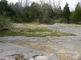
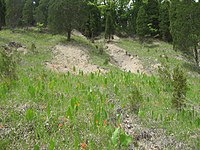
A calcareous glade is a type of ecological community that is found in the central Eastern United States. Calcareous glades occur where bedrock such as limestone occurs near or at the surface, and have very shallow and little soil development. Due to the shallow soil and the extreme conditions created by it, trees are often unable to grow in the glades. This creates a habitat that is usually sunny, dry, and hot. Calcareous glade vegetation is more similar to that of a desert habitat than a grassland, being dominated by small spring annuals with occasional geophytic or succulent perennials.

<span class="mw-page-title-main">Appalachian mixed mesophytic forests</span> Temperate broadleaf and mixed forests ecoregion of the United States

The Appalachian mixed mesophytic forests is an ecoregion of the temperate broadleaf and mixed forests biome, as defined by the World Wildlife Fund. It consists of mesophytic plants west of the Appalachian Mountains in the Southeastern United States.

<span class="mw-page-title-main">Nashville metropolitan area</span> Metropolitan area in Tennessee, United States

The Nashville metropolitan area is a metropolitan statistical area centered on Nashville, Tennessee, the capital and largest city in Tennessee, in the United States. With a population of just over 2 million, it is the most populous metropolitan area in Tennessee. It is also the largest metropolitan area in Tennessee, in terms of land area.

<span class="mw-page-title-main">Central U.S. hardwood forests</span> Temperate broadleaf and mixed forests ecoregion of the United States

The central U.S. hardwood forests comprise a temperate broadleaf and mixed forests ecoregion in the Eastern United States, as defined by the World Wildlife Fund. It has one of the most diverse herbaceous plant floras of ecoregions in North America.

<span class="mw-page-title-main">Appalachian–Blue Ridge forests</span> Temperate broadleaf and mixed forests ecoregion of the United States

The Appalachian–Blue Ridge forests are an ecoregion in the Temperate broadleaf and mixed forests Biome, in the Eastern United States. The ecoregion is located in the central and southern Appalachian Mountains, including the Ridge-and-Valley Appalachians and the Blue Ridge Mountains. It covers an area of about 61,500 square miles (159,000 km2) in: northeast Alabama and Georgia, northwest South Carolina, eastern Tennessee, western North Carolina, Virginia, Maryland, and central West Virginia and Pennsylvania; and small extensions into Kentucky, New Jersey, and New York.

The U.S. state of Tennessee is geographically diverse, with varying terrains and several distinct physiographic regions. Its landforms range from the Blue Ridge Mountains in the eastern part of the state to flat and fertile plains along the Mississippi River. The state is geographically, legally, culturally, and economically divided into three Grand Divisions: East Tennessee, Middle Tennessee, and West Tennessee.

<span class="mw-page-title-main">Cedars of Lebanon State Park</span> State park in Tennessee, United States

Cedars of Lebanon State Park is a state park in Wilson County, Tennessee, in the southeastern United States. It consists of 900 acres (364 ha) situated amidst the 9,420-acre (3,810 ha) Cedars of Lebanon State Forest. The park and forest are approximately 10 miles (16 km) south of Lebanon, Tennessee.

<span class="mw-page-title-main">Ozark Highlands (ecoregion)</span>

The Ozark Highlands is a Level III ecoregion designated by the Environmental Protection Agency (EPA) in four U.S. states. Most of the region is within Missouri, with a part in Arkansas and small sections in Oklahoma and Kansas. It is the largest subdivision of the region known as the Ozark Mountains, less rugged in comparison to the Boston Mountains in Arkansas, the highest part of the Ozarks.

The Window Cliffs State Natural Area covers 275 acres (111 ha) in Putnam County, Tennessee, near Cookeville. The Window Cliffs is the name of a prominent group of natural bridges in a narrow 200-foot-tall (61 m) ridge in the neck of a meander of Cane Creek. The day-use area is only accessible by hiking a 2.7 miles (4.3 km) trail. The Window Cliffs was an acclaimed destination in the nineteenth and early twentieth centuries. The area contains several state-listed endangered plants.

The Southern Appalachian low-elevation pine forest is a forest system that occurs in Indiana, Kentucky, Tennessee, Alabama, Virginia, North Carolina, South Carolina, and Georgia. It is found in the lower elevations of the southern Appalachian Mountains and adjacent Piedmont and Cumberland Plateau, extending into part of the Interior Low Plateaus. Pine Mountain is a great example of this forest type, as well as Sweat Mountain in the northern part of the Atlanta metropolitan area. Both of these mountain ridges are dominated by Pinus virginiana

The Allegheny–Cumberland dry oak forest and woodland is a forest system found in Ohio, West Virginia, Virginia, Kentucky, Tennessee, Alabama, and Georgia.

The Southern Ridge and Valley / Cumberland dry calcareous forest is a forest system found in Alabama, Georgia, Tennessee, Kentucky, Virginia, and West Virginia.

<span class="mw-page-title-main">Southeastern conifer forests</span> Temperate coniferous forests ecoregion of the United States

The Southeastern conifer forests are a temperate coniferous forest ecoregion of the southeastern United States. It is the largest conifer forest ecoregion east of the Mississippi River. It is also the southernmost instance of temperate coniferous forest within the Nearctic realm.

The Southern coastal plain oak dome and hammock is a forest type occurring in small patches in Florida, Georgia, Alabama, and Mississippi. These forests consist of thick stands of evergreen oaks on shallow depressions or slight hills. They are distinct from their surrounding habitats, which are often woodlands dominated by longleaf pine.

<span class="mw-page-title-main">Arkansas Valley (ecoregion)</span>

The Arkansas Valley is a Level III ecoregion designated by the Environmental Protection Agency (EPA) in the U.S. states of Arkansas and Oklahoma. It parallels the Arkansas River between the flat plains of western Oklahoma and the Arkansas Delta, dividing the Ozarks and the Ouachita Mountains with the broad valleys created by the river's floodplain, occasionally interrupted by low hills, scattered ridges, and mountains. In Arkansas, the region is often known as the Arkansas River Valley, especially when describing the history and culture of the region.

References

  1. 1 2 3 4 Hoekstra, J. M.; Molnar, J. L.; Jennings, M.; Revenga, C.; Spalding, M. D.; Boucher, T. M.; Robertson, J. C.; Heibel, T. J.; Ellison, K. (2010). Molnar, J. L. (ed.). The Atlas of Global Conservation: Changes, Challenges, and Opportunities to Make a Difference . University of California Press. ISBN   978-0-520-26256-0.
  2. Fralish, James S. (2003). "The Central Hardwood Forest: Its Boundaries and Physiographic Provinces". General Technical Report NC-234. U.S. Dept. of Agriculture, Forest Service, North Central Research Station. p. 3. Archived from the original on 2012-02-18. Retrieved 2008-10-05. (cites definition by Braun 1950)
  3. Jones, Ronald L. Plant Life of Kentucky:An Illustrated Guide to Vascular Flora. University Press of Kentucky.
  4. 1 2 3 4 5 6 Jones, Ron (2005). Plant Life of Kentucky. The University Press, Kentucky. pp. 14–15.
  5. Pennyroyal Plain Prairies, by Dwayne Estes, Botanical Research Institute of Texas
  6. 1 2 3 4 Chester, Edward (2015). Guide to the Vascular Plants of Tennessee.
  7. The Barrens, Cultural Resources Program of Fort Campbell
  8. Jackson, Marion (1997). The Natural Heritage of Indiana. Indiana University Press.
  9. McEwan, Ryan; McCarthy, Brian (2008). "Anthropogenic Disturbance and the Formation of Oak Savanna in Central Kentucky, USA". Journal of Biogeography. 35 (5): 965–975. doi:10.1111/j.1365-2699.2007.01857.x. JSTOR   30142885.
  10. Campbell, Julian (1989). "Historical evidence for forest composition in the Bluegrass Region in Kentucky" (PDF). Proceedings of the Seventh Central Hardwood Forest Conference, 5–8 March 1989: 231–246.
  11. The Cedar Glade Ecosystems of Middle Tennessee
  12. Morrison Meadow, Tennessee Natural Heritage Program
  13. Interior Low Plateau Seepage Fen, NatureServe
  14. Sunnybell Cedar Glade State Natural Area, Tennessee Natural Heritage Program
  15. Native Wetlands of the Central Bluegrass Region: from seeps to streamheads to swamps to ponds, By Julian Campbell
  16. The Nature Conservancy
  17. https://www.wku.edu/greenriver/ WKU Green River Preserve
  18. Haag, Wendell (2012). North American Freshwater Mussels: Natural History, Ecology, and Conservation. pp. 102–103.
  19. 1 2 3 Dey, Daniel C.; Richard P. Guyette (2000). "Sustaining Oak Ecosystems in the Central Hardwood Region: Lessons from the Past--Continuing the History of Disturbance". Trans. 65th No. Amer. Wildl. and Natur. Resour. Conf. p. 170-183. Retrieved 2008-10-15.