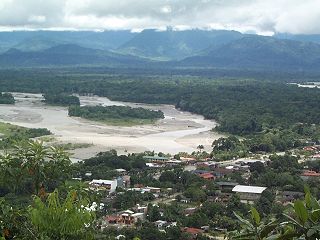
Quillacollo is a province in the Cochabamba Department, Bolivia. It is known for its festival in August where people from all over Bolivia come and pay homage to the Virgin of Urqupiña. Quillacollo is said to be one of the fastest growing cities in Bolivia.

Nor Chichas is a province in the Eastern parts of the Bolivian Potosí Department. Its seat is Cotagaita.

Oropeza is a province in the Chuquisaca Department, Bolivia. Its seat is Sucre which is also the constitutional capital of Bolivia and the capital of the Chuquisaca Department.

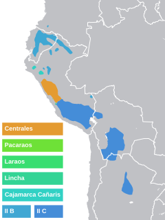
South Bolivian Quechua, also known as Central Bolivian Quechua, is a dialect of Southern Quechua spoken in Bolivia and adjacent areas of Argentina, where it is also known as Colla. It is not to be confused with North Bolivian Quechua, which is spoken on the northern Andean slopes of Bolivia and is phonologically distinct from the South Bolivian variety. Estimates of the number of speakers of South Bolivian Quechua range from 2.3 to 2.8 million, making it the most spoken indigenous language in Bolivia, just slightly greater than Aymara, with roughly 2 million speakers in Bolivia. In comparison, the North Bolivian dialect has roughly 116,000 speakers.

Villa Tunari or Tunari is a location in the department of Cochabamba, Bolivia. It is the seat of the Villa Tunari Municipality, the third municipal section of the Chapare Province. According to the census 2012 the population was 3,213 in the town which is an increment from 2,510 registered during the 2001 census.

Víctor Fajardo Province is a province in the centre of the Ayacucho Region in Peru.

Vilcas Huamán is a province in the eastern part of the Ayacucho Region in Peru.

Chilcayoc or Ch'illkayuq is the smallest of 11 districts of the Sucre Province in the Ayacucho region in Peru.

Inti Punku or Intipunku is an archaeological site in the Cusco Region of Peru that was once a fortress of the sacred city, Machu Picchu. It is now also the name of the final section of the Incan Trail between the Sun Gate complex and the city of Machu Picchu. It was believed that the steps were a control gate for those who enter and exited the Sanctuary.

Pocona Municipality is the third municipal section of the Carrasco Province in the Cochabamba Department in Bolivia. Its seat is Pocona. At the time of census 2001 the municipality had 13,488 inhabitants.

Intihuatana at the archaeological site of Machu Picchu is a notable ritual stone associated with the astronomic clock or calendar of the Inca in South America. Machu Picchu was thought to have been built c. 1450 by the Sapa Inca Pachacuti as a country estate, although it is equally likely that the Inca discovered much older ruins and opted to build this majestic estate on older foundations.. In the late 16th century, the Viceroy Francisco de Toledo and the clergy destroyed those Intihuatana which they could find. They did so as they believed that the Incas' religion was a blasphemy and the religious significance of the Intihuatana could be a political liability. The Intihuatana of Machu Picchu was found intact by Bingham in 1911, indicating that the Spanish conquerors had not found it.

Intihuatana is a ritual stone in South America associated with the astronomic clock or calendar of the Inca. Its name is derived from the local Quechua language. The most notable Intihuatana is an archaeological site located at Machu Picchu in the Sacred Valley near Machu Picchu, Peru. The name of the stone is derived from Quechua: inti means "sun", and wata- is the verb root "to tie, hitch (up)". The Quechua -na suffix derives nouns for tools or places. Hence inti watana is literally an instrument or place to "tie up the sun", often expressed in English as "The Hitching Post of the Sun".

Jatun Rumi is a mountain in the Andes of Bolivia which reaches a height of approximately 4,360 m (14,300 ft). It is located in the Potosí Department, Nor Chichas Province, Cotagaita Municipality.

Iskay Rumi is a 4,782-metre-high (15,689 ft) mountain in the Andes of Bolivia. It is located in the Potosí Department, Nor Chichas Province, Cotagaita Municipality. Iskay Rumi lies northwest of the mining town of Santa Bárbara.

Ch'utu Urqu is a mountain in the Andes of Bolivia which reaches a height of approximately 4,180 m (13,710 ft). It is located in the Potosí Department, Nor Chichas Province, Cotagaita Municipality. Ch'utu Urqu lies northwest of Iskay Rumi.

Rumi Kancha is a mountain in the Andes of Bolivia which reaches a height of approximately 3,880 m (12,730 ft). It is located in the Potosí Department, Nor Chichas Province, Cotagaita Municipality. Rumi Kancha lies south of Achakanayuq.

Ch'aki Mayu is a 3,654-metre-high (11,988 ft) mountain in the Bolivian Andes. It is located in the Chuquisaca Department, Oropeza Province, Sucre Municipality.

Jatun Q'asa is a 3,568-metre-high (11,706 ft) mountain in the Bolivian Andes. It is located in the Chuquisaca Department, Oropeza Province, on the border of the municipalities of Sucre and Yotala.

Rumi Rumiyuq is a mountain in the Bolivian Andes which reaches a height of approximately 4,160 m (13,650 ft). It is located in the Cochabamba Department, Carrasco Province, Pocona Municipality. Rumi Rumiyuq lies east of Qucha Quchayuq Urqu and southeast of Iskay Wasi.


