Tokushima Prefecture is a prefecture of Japan located on the island of Shikoku. Tokushima Prefecture has a population of 728,633 and has a geographic area of 4,146 km2. Tokushima Prefecture borders Kagawa Prefecture to the north, Ehime Prefecture to the west, and Kōchi Prefecture to the southwest.

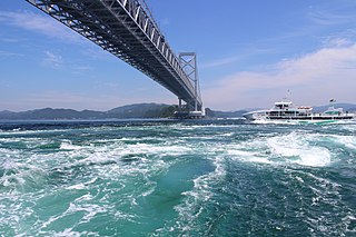
Naruto is a city located in Tokushima Prefecture, Japan. As of 30 June 2022, the city had an estimated population of 54,989 in 26,206 households and a population density of 410 persons per km2. The total area of the city is 191.11 square kilometres (73.79 sq mi).

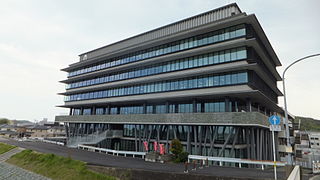
Komatsushima is a city located in Tokushima Prefecture, Japan. As of 30 June 2022, the city had an estimated population of 36,128 in 17181 households and a population density of 800 persons per km². The total area of the city is 45.37 square kilometres (17.52 sq mi).
Anan is a city in Tokushima Prefecture, Japan. As of 30 June 2022, the city had an estimated population of 70,285 in 31313 households and a population density of 250 persons per km². The total area of the city is 279.25 square kilometres (107.82 sq mi).

Sanuki is a city in Kagawa Prefecture, Japan. As of 1 September 2022, the city had an estimated population of 46,016 in 20847 households and a population density of and a population density of 290 persons per km2. The total area of the city is 158.63 square kilometres (61.25 sq mi).

Katsuura is a town located in Katsuura District, Tokushima Prefecture, Japan. As of 30 June 2022, the town had an estimated population of 4,884 in 2159 households and a population density of 70 persons per km². The total area of the town is 69.85 square kilometres (26.97 sq mi).

Sanagōchi is a village located in Myōdō District, Tokushima Prefecture, Japan. As of 30 June 2022, the village had an estimated population of 1983 and a population density of 47 persons per km².The total area of the village is 42.28 square kilometres (16.32 sq mi). Sanagōchi is the only village remaining in Tokushima Prefecture.

Kamiyama is a town in Myōzai District, Tokushima Prefecture, Japan. As of 30 June 2022, the town had an estimated population of 4,930 in 2404 households and a population density of 28 persons per km². The total area of the town is 173.305 square kilometres (66.913 sq mi).

Matsushige is a town located in Itano District, Tokushima Prefecture, Japan. As of 1 April 2022, the town had an estimated population of 14,770 in 6794 households and a population density of 1000 persons per km². The total area of the town is 14.24 square kilometres (5.50 sq mi). Matsushige is the location of Tokushima Airport, from where domestic flights depart for various other Japanese cities. The town also hosts a Japan Maritime Self-Defense Force base.

Kitajima is a town located in Itano District, Tokushima Prefecture, Japan. As of 1 December 2023, the town had an estimated population of 23,680 in 10340 households and a population density of 2700 persons per km2. The total area of the town is 8.74 square kilometres (3.37 sq mi). It has the smallest area among local governments in Tokushima prefecture and is also the most densely populated town or village in Shikoku.

Aizumi is a town located in Itano District, in northeastern Tokushima Prefecture, Japan. As of 30 June 2022, the town had an estimated population of 35,512 in 15198 households and a population density of 2200 persons per km2. The total area of the town is 16.27 square kilometres (6.28 sq mi).

Itano is a town located in Itano District, Tokushima Prefecture, Japan. As of 30 June 2022, the town had an estimated population of 13,105 in 5790 households and a population density of 360 persons per km². The total area of the town is 36.22 square kilometres (13.98 sq mi).

Kamiita is a town located in Itano District, Tokushima Prefecture, Japan. As of 30 June 2022, the town had an estimated population of 11,725 in 4951 households and a population density of 340 persons per km2. The total area of the town is 34.58 square kilometres (13.35 sq mi).

Awa is a city located in Tokushima Prefecture, Japan. As of 30 June 2022, the city had an estimated population of 35,631 in 15432 households and a population density of 190 persons per km2. The total area of the city is 191.11 square kilometres (73.79 sq mi).

Yoshinogawa is a city located in Tokushima Prefecture, Japan. As of 30 June 2022, the city had an estimated population of 39,150 in 17958 households and a population density of 270 persons per km². The total area of the city is 144.14 square kilometres (55.65 sq mi).

Miyoshi is a city located in Tokushima Prefecture, Japan. As of 30 June 2022, the city had an estimated population of 23,782 in 12103 households and a population density of 33 persons per km2. The total area of the city is 721.42 square kilometres (278.54 sq mi).

Tokushima is the capital city of Tokushima Prefecture on Shikoku island in Japan. As of 1 September 2024, the city had an estimated population of 245,264 in 122,539 households and a population density of 1,280 persons per km². The total area of the city is 191.52 square kilometres (73.95 sq mi).

Higashimiyoshi is a town located in Miyoshi District, Tokushima Prefecture, Japan. As of 30 June 2022, the town had an estimated population of 13,733 in 6281 households and a population density of 110 persons per km². The total area of the town is 122.48 square kilometres (47.29 sq mi).

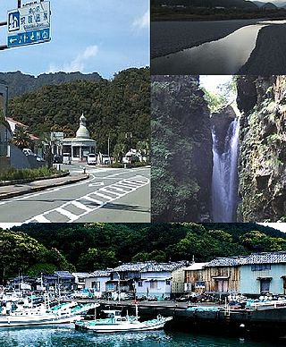
Minami is a town located in Kaifu District, Tokushima Prefecture, Japan. As of 30 June 2022, the town had an estimated population of 6,142 in 3139 households and a population density of 44 persons per km². The total area of the town is 140.80 square kilometres (54.36 sq mi).
Kaiyō is a town located in Kaifu District, Tokushima Prefecture, Japan. As of 1 May 2022, the town had an estimated population of 8,699 in 4488 households and a population density of 27 persons per km². The total area of the town is 327.65 square kilometres (126.51 sq mi).


