Islote, Arecibo, Puerto Rico

Last updated
Islote
Barrio
Homes in Islote, Arecibo, Puerto Rico.jpg
Townhouses behind wrought iron fences in Islote
Islote, Arecibo, Puerto Rico locator map.png
Location of Islote within the municipality of Arecibo shown in red
Caribbean location map.svg
Red pog.svg
Islote
Location of Puerto Rico
Coordinates: 18°28′54″N66°38′50″W / 18.481747°N 66.647162°W / 18.481747; -66.647162 [1]
Commonwealth Flag of Puerto Rico.svg  Puerto Rico
Municipality Bandera de Arecibo, Puerto Rico.svg Arecibo
Area
[1]
  Total9.63 sq mi (24.9 km2)
  Land7.28 sq mi (18.9 km2)
  Water2.35 sq mi (6.1 km2)
Elevation
[2]
23 ft (7 m)
Population
 (2010)
  Total5,665
  Density778.2/sq mi (300.5/km2)
 Source: 2010 Census
Time zone UTC−4 (AST)

Islote is a barrio in the municipality of Arecibo, Puerto Rico. Its population in 2010 was 5,665. [3] [4] [5] "Birth of a New World", a giant sculpture of Christopher Columbus on a ship, is located in Islote.

Contents

History

Crab in Islote Crab in Islote, Arecibo, Puerto Rico.jpg
Crab in Islote

Islote was in Spain's gazetteers [6] until Puerto Rico was ceded by Spain in the aftermath of the Spanish–American War under the terms of the Treaty of Paris of 1898 and became an unincorporated territory of the United States. In 1899, the United States Department of War conducted a census of Puerto Rico finding that the population of Islote barrio was 2,498. [7]

Historical population
CensusPop.Note
1900 2,498
1910 2,90816.4%
1920 2,9170.3%
1930 3,1066.5%
1940 3,56214.7%
1950 3,110−12.7%
1960 2,660−14.5%
1970 2,445−8.1%
1980 4,45882.3%
1990 5,78529.8%
2000 6,0805.1%
2010 5,665−6.8%
U.S. Decennial Census
1899 (shown as 1900) [8] 1910-1930 [9]
1930-1950 [10] 1980-2000 [11] 2010 [12]

Sectors

Barrios (which are, in contemporary times, roughly comparable to minor civil divisions) [13] in turn are further subdivided into smaller local populated place areas/units called sectores (sectors in English). The types of sectores may vary, from normally sector to urbanización to reparto to barriada to residencial, among others. [14] [15] [16]

The following sectors are in Islote barrio: [17] [18]

Callejón del Cristo (Callejón del Diablo), Callejón Francés Apartamentos Oceanía, Comunidad Islote I y II, Comunidad Jarealito, Comunidad Vigía, Condominios Atlántica, Sector Boán, Sector Caracoles, Sector Cueva del Indio, Sector El Callejón, Sector La Vía, Sector Melilla, Sector Pasaje, Sector Piquiña, Sector Rincón Chiquito, Sector Rincón Grande, Sector Vívora, Urbanización Brisas de Palma Roja, Urbanización Brisas del Mar I y II, Urbanización Corales del Mar, Urbanización Costa de Oro, Urbanización Costa del Atlántico, Urbanización Costas del Mar, and Urbanización Reparto Maritza.

Birth of a New World

Birth of the New World, a 360 foot (110 m) bronze sculpture of Christopher Columbus and a ship is located on the Atlantic coastline, in Islote. [19]

See also

Related Research Articles

<span class="mw-page-title-main">Hato Nuevo, Guaynabo, Puerto Rico</span> Barrio of Puerto Rico

Hato Nuevo is a barrio in the municipality of Guaynabo, Puerto Rico. Its population in 2010 was 4,114.

<span class="mw-page-title-main">Candelaria, Toa Baja, Puerto Rico</span> Barrio of Puerto Rico

Candelaria is a barrio in the municipality of Toa Baja, Puerto Rico. Its population in 2010 was 23,343.

<span class="mw-page-title-main">Sonador</span> Barrio of San Sebastián, Puerto Rico

Sonador is a barrio in the municipality of San Sebastián, Puerto Rico. Its population in 2010 was 1,813.

<span class="mw-page-title-main">Mucarabones</span> Barrio of Toa Alta, Puerto Rico

Mucarabones is a barrio in the municipality of Toa Alta, Puerto Rico. Its population in 2010 was 23,221.

<span class="mw-page-title-main">Quemados, San Lorenzo, Puerto Rico</span> Barrio of Puerto Rico

Quemados is a barrio in the municipality of San Lorenzo, Puerto Rico. Its population in 2010 was 4,712.

<span class="mw-page-title-main">Santana, Arecibo, Puerto Rico</span> Barrio of Puerto Rico

Santana is a barrio in the municipality of Arecibo, Puerto Rico. Its population in 2010 was 5,253.

<span class="mw-page-title-main">Garrochales, Arecibo, Puerto Rico</span> Barrio of Puerto Rico

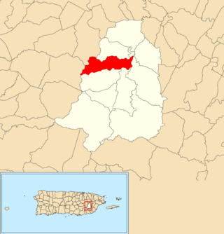
Garrochales is a barrio located in the northeastern area of the municipality of Arecibo, Puerto Rico. Its population in 2010 was 2,433.

<span class="mw-page-title-main">Arenalejos, Arecibo, Puerto Rico</span> Barrio of Puerto Rico

Arenalejos is a barrio in the municipality of Arecibo, Puerto Rico. Its population in 2010 was 3,064. Arenalejos is near the center of Arecibo, west of Miraflores.

<span class="mw-page-title-main">Cambalache, Arecibo, Puerto Rico</span> Barrio of Puerto Rico

Cambalache is a barrio in the municipality of Arecibo, Puerto Rico. Its population in 2010 was 40.

<span class="mw-page-title-main">Domingo Ruíz, Arecibo, Puerto Rico</span> Barrio of Puerto Rico

Domingo Ruíz is a barrio in the municipality of Arecibo, Puerto Rico. Its population in 2010 was 3,153.

<span class="mw-page-title-main">Dominguito, Arecibo, Puerto Rico</span> Barrio of Puerto Rico

Dominguito is a barrio in the municipality of Arecibo, Puerto Rico. Its population in 2010 was 4,895.

<span class="mw-page-title-main">Esperanza, Arecibo, Puerto Rico</span> Barrio of Puerto Rico

Esperanza is a barrio in the municipality of Arecibo, Puerto Rico. Its population in 2010 was 1,882.

<span class="mw-page-title-main">Factor, Arecibo, Puerto Rico</span> Barrio of Puerto Rico

Factor is a barrio in the municipality of Arecibo, Puerto Rico. Its population in 2010 was 8,001.

<span class="mw-page-title-main">Hato Abajo, Arecibo, Puerto Rico</span> Barrio of Puerto Rico

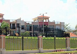
Hato Abajo is a barrio in the municipality of Arecibo, Puerto Rico. Its population in 2010 was 19,699.

<span class="mw-page-title-main">Sabana Hoyos, Arecibo, Puerto Rico</span> Barrio of Puerto Rico

Sabana Hoyos is a barrio in the municipality of Arecibo, Puerto Rico. Its population in 2010 was 10,745.

<span class="mw-page-title-main">Unibón</span> Barrio of Morovis, Puerto Rico

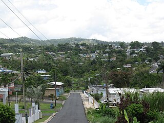
Unibón is a barrio in the municipality of Morovis, Puerto Rico. Unibón has fifteen sectors and its population in 2010 was 3,853.

<span class="mw-page-title-main">Jiménez, Río Grande, Puerto Rico</span> Barrio of Puerto Rico

Jiménez is a barrio in the municipality of Río Grande, Puerto Rico. Its population in 2010 was 2,925.

<span class="mw-page-title-main">Zarzal, Río Grande, Puerto Rico</span> Barrio of Puerto Rico

Zarzal is a barrio in the municipality of Río Grande, Puerto Rico. Its population in 2010 was 14,314.

<span class="mw-page-title-main">Bayamón, Cidra, Puerto Rico</span> Barrio of Puerto Rico

Bayamón is a barrio in the municipality of Cidra, Puerto Rico. Its population in 2010 was 5,995.

References

  1. 1 2 "US Gazetteer 2019". US Census. US Government.
  2. U.S. Geological Survey Geographic Names Information System: Islote barrio
  3. Picó, Rafael; Buitrago de Santiago, Zayda; Berrios, Hector H. Nueva geografía de Puerto Rico: física, económica, y social, por Rafael Picó. Con la colaboración de Zayda Buitrago de Santiago y Héctor H. Berrios. San Juan Editorial Universitaria, Universidad de Puerto Rico,1969.
  4. Gwillim Law (20 May 2015). Administrative Subdivisions of Countries: A Comprehensive World Reference, 1900 through 1998. McFarland. p. 300. ISBN   978-1-4766-0447-3 . Retrieved 25 December 2018.
  5. Puerto Rico: 2010 Population and Housing Unit Counts.pdf (PDF). U.S. Dept. of Commerce, Economics and Statistics Administration, U.S. Census Bureau. 2010.
  6. "Anuario del comercio, de la industria, de la magistratura y de la administración. 1881". Biblioteca Nacional de España (in Spanish). p. 1614. Retrieved 4 April 2023.
  7. Joseph Prentiss Sanger; Henry Gannett; Walter Francis Willcox (1900). Informe sobre el censo de Puerto Rico, 1899, United States. War Dept. Porto Rico Census Office (in Spanish). Imprenta del gobierno. p.  160.
  8. "Report of the Census of Porto Rico 1899". War Department Office Director Census of Porto Rico. Archived from the original on July 16, 2017. Retrieved September 21, 2017.
  9. "Table 3-Population of Municipalities: 1930 1920 and 1910" (PDF). United States Census Bureau. Archived (PDF) from the original on August 17, 2017. Retrieved September 21, 2017.
  10. "Table 4-Area and Population of Municipalities Urban and Rural: 1930 to 1950" (PDF). United States Census Bureau. Archived (PDF) from the original on August 30, 2015. Retrieved September 21, 2014.
  11. "Table 2 Population and Housing Units: 1960 to 2000" (PDF). United States Census Bureau. Archived (PDF) from the original on July 24, 2017. Retrieved September 21, 2017.
  12. Puerto Rico: 2010 Population and Housing Unit Counts.pdf (PDF). U.S. Dept. of Commerce Economics and Statistics Administration U.S. Census Bureau. 2010. Archived (PDF) from the original on 2017-02-20. Retrieved 2019-08-02.
  13. "US Census Barrio-Pueblo definition". factfinder.com. US Census. Archived from the original on 13 May 2017. Retrieved 5 January 2019.
  14. "Agencia: Oficina del Coordinador General para el Financiamiento Socioeconómico y la Autogestión (Proposed 2016 Budget)". Puerto Rico Budgets (in Spanish). Retrieved 28 June 2019.
  15. Rivera Quintero, Marcia (2014), El vuelo de la esperanza: Proyecto de las Comunidades Especiales Puerto Rico, 1997-2004 (first ed.), San Juan, Puerto Rico Fundación Sila M. Calderón, ISBN   978-0-9820806-1-0
  16. "Leyes del 2001". Lex Juris Puerto Rico (in Spanish). Retrieved 24 June 2020.
  17. "PRECINTO ELECTORAL ARECIBO 026" (PDF). Comisión Estatal de Elecciones (in Spanish). PR Government. 19 October 2018. Retrieved 2 August 2020.
  18. "PRECINTO ELECTORAL ARECIBO 027" (PDF). Comisión Estatal de Elecciones (in Spanish). PR Government. 8 October 2019. Retrieved 2 August 2020.
  19. "Culpable Cristóbal Colón... ¡del tapón!". Primera Hora (in Spanish). 22 June 2020. Retrieved 23 June 2020.