Jackson Township | |
|---|---|
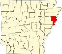
 Jackson Township Location in Arkansas  Jackson Township Jackson Township (the United States) | |
| Coordinates: 35°12′22″N90°20′04″W / 35.206155°N 90.334483°W [1] | |
| Country | United States |
| State | Arkansas |
| County | Crittenden |
| Area | |
• Total | 57.587 sq mi (149.15 km2) |
| • Land | 57.587 sq mi (149.15 km2) |
| • Water | 0.000 sq mi (0 km2) |
| Elevation | 213 ft (65 m) |
| Population | |
• Total | 1,352 |
| • Density | 23.48/sq mi (9.065/km2) |
| Time zone | UTC-6 (CST) |
| • Summer (DST) | UTC-5 (CDT) |
| FIPS code [2] [3] | 05-91857 |
| GNIS ID [2] [3] | 68748 |
Jackson Township is a township in Crittenden County, Arkansas, United States. [4] Its total population was 1,352 as of the 2010 United States census, [1] [5] a decrease of 1.24 percent from 1,369 at the 2000 census. [6] [7]
According to the 2010 Census, Jackson Township is located at 35°12′22″N90°20′04″W / 35.206155°N 90.334483°W (35.206155, -90.334483). [1] It has a total area of 57.587 square miles (149.15 square kilometers); all of which is land. [1] As per the USGS National Elevation Dataset, the elevation is 213 feet (65 m). [2]
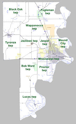
Crawfordsville, and parts of Marion, West Memphis, and Jennette are located within the township. [4]