
Berbers, or the Berber peoples, also called by their endonym Amazigh or Imazighen, are a diverse grouping of distinct ethnic groups indigenous to North Africa who predate the arrival of Arabs in the Arab migrations to the Maghreb. Their main connections are identified by their usage of Berber languages, most of them mutually unintelligible, which are part of the Afroasiatic language family. They are indigenous to the Maghreb region of North Africa, where they live in scattered communities across parts of Morocco, Algeria, Libya, and to a lesser extent Tunisia, Mauritania, northern Mali and northern Niger. Smaller Berber communities are also found in Burkina Faso and Egypt's Siwa Oasis.

The Libyan Desert is a geographical region filling the northeastern Sahara Desert, from eastern Libya to the Western Desert of Egypt and far northwestern Sudan. On medieval maps, its use predates today's Sahara, and parts of the Libyan Desert include the Sahara's most arid and least populated regions; this is chiefly what sets the Libyan Desert apart from the greater Sahara. The consequent absence of grazing, and near absence of waterholes or wells needed to sustain camel caravans, prevented Trans-Saharan trade between Kharga close to the Nile, and Murzuk in the Libyan Fezzan. This obscurity saw the region overlooked by early European explorers, and it was not until the early 20th century and the advent of the motor car before the Libyan Desert started to be fully explored.

Transhumance is a type of pastoralism or nomadism, a seasonal movement of livestock between fixed summer and winter pastures. In montane regions, it implies movement between higher pastures in summer and lower valleys in winter. Herders have a permanent home, typically in valleys. Generally only the herds travel, with a certain number of people necessary to tend them, while the main population stays at the base. In contrast, movement in plains or plateaus (horizontal transhumance) is more susceptible to being disrupted by climatic, economic, or political change.

The Vercors massif are a range in France consisting of rugged plateaus and mountains straddling the départements of Isère and Drôme in the French Prealps. It lies west of the Dauphiné Alps, from which it is separated by the rivers Drac and Isère. The cliffs at the massif's eastern limit face the city of Grenoble.

The Sahara is a desert spanning across North Africa. With an area of 9,200,000 square kilometres (3,600,000 sq mi), it is the largest hot desert in the world and the third-largest desert overall, smaller only than the deserts of Antarctica and the northern Arctic.
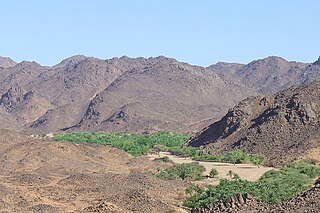
The Aïr Mountains or Aïr Massif is a triangular massif, located in northern Niger, within the Sahara. Part of the West Saharan montane xeric woodlands ecoregion, they rise to more than 1,800 m (5,900 ft) and extend over 84,000 km2 (32,000 sq mi). Lying in the midst of desert north of the 17th parallel, the Aïr plateau, with an average altitude between 500 and 900 m, forms an island of Sahel climate which supports a wide variety of life, many pastoral and farming communities, and dramatic geological and archaeological sites. There are notable archaeological excavations in the region that illustrate the prehistoric past of this region. The endangered African wild dog once existed in this region, but may now be extirpated due to human population pressures in this region.

The Marrah Mountains or Marra Mountains are a range of volcanic peaks in a massif that rises up to 3,042 metres (9,980 ft). They are the highest mountains in Sudan.

Ifrane is a city in the Middle Atlas region of northern Morocco. The capital of Ifrane Province in the region of Fès-Meknès, Ifrane is located at an elevation of 1,665 m (5,463 ft). In the regional Tamazight language, "ifran" means caves.
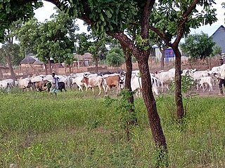
Nomadic pastoralism is a form of pastoralism in which livestock are herded in order to seek for fresh pastures on which to graze. True nomads follow an irregular pattern of movement, in contrast with transhumance, where seasonal pastures are fixed. However, this distinction is often not observed and the term 'nomad' used for both—and in historical cases the regularity of movements is often unknown in any case. The herded livestock include cattle, water buffalo, yaks, llamas, sheep, goats, reindeer, horses, donkeys or camels, or mixtures of species. Nomadic pastoralism is commonly practised in regions with little arable land, typically in the developing world, especially in the steppe lands north of the agricultural zone of Eurasia. Pastoralists often trade with sedentary agrarians, exchanging meat for grains, however have been known to raid.
Azilal is a provincial capital in central Morocco, in the Atlas Mountains. It is also the capital of the M'Goun Conservation Area.

The Anti-Atlas, also known as Lesser Atlas or Little Atlas, is a mountain range in Morocco, a part of the Atlas Mountains in the northwest of Africa. The Anti-Atlas extends from the Atlantic Ocean in the southwest toward the northeast, to the heights of Ouarzazate and further east to the city of Tafilalt, altogether a distance of approximately 500 km. The range borders on the Sahara to the south.

The Middle Atlas is a mountain range in Morocco. It is part of the Atlas mountain range, a mountainous region with more than 100,000 km2, 15 percent of its landmass, rising above 2,000 metres. The Middle Atlas is the northernmost and second highest of three main Atlas Mountains chains of Morocco. To south, separated by the Moulouya and Um Er-Rbiâ rivers, lies the High Atlas. The Middle Atlas form the westernmost end of a large plateaued basin extending eastward into Algeria, also bounded by the Tell Atlas to the north and the Saharan Atlas to the south, both lying largely in Algeria. North of the Middle Atlas and separated by the Sebou River, lie the Rif mountains which are an extension of the Baetic System, which includes the Sierra Nevada in the south of Spain. The basin of the Sebou is not only the primary transportation route between Atlantic Morocco and Mediterranean Morocco but is an area, watered by the Middle Atlas range, that constitutes the principal agricultural region of the country.

Mount Uwaynat or Gabal El Uweinat is a mountain range in the area of the Egyptian-Libyan-Sudanese tripoint. Because of thousands of prehistoric rock art sites, it is considered an important witness to the development of early pastoralism in the Sahara.

Dawadmi or Ad Dawadimi is a town in Riyadh Province, Saudi Arabia. Google Maps spells the name as Al Duwadimi. As of the 2022 census it had a population of 563,861 people. The town is mostly inhabited by the tribe of Banu 'Utaybah.

The Mediterranean woodlands and forests is an ecoregion in the coastal plains, hills, and mountains bordering the Mediterranean Sea and Atlantic Ocean in North Africa. It has a Mediterranean climate, and is in the Mediterranean forests, woodlands, and scrub biome.

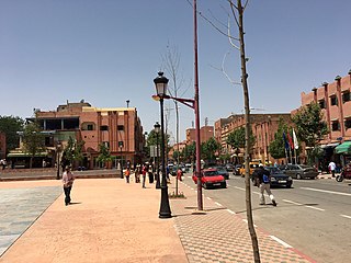
The Agdal Gardens are a large area of historic gardens and orchards in Marrakesh, Morocco. The gardens are located to the south of the city's historic Kasbah and its royal palace. Together with the medina of Marrakech and the Menara Gardens, the Agdal Gardens were listed by UNESCO as a World Heritage Site in 1985. The gardens contain several historic water reservoirs as well as several historic palaces and pavilions, including the Dar el-Hana and the Dar al-Bayda.

The Intercontinental Biosphere Reserve of the Mediterranean is the first of its type to be designated by the Man and the Biosphere Programme. It combines the Tingitan Peninsula in Morocco and the southern Iberian Peninsula of Andalusia. Both countries are located in a biogeographic region of deciduous forests and evergreen sclerophyllous scrub within the Mediterranean bioclimatic zone. The maritime area of the biosphere reserve is dominated by the Strait of Gibraltar, which links the two peninsulas. The reserve also encompasses natural and human communication routes between Africa and Europe.

Jubbah or Jubbat Ha'il is a city in Ha'il Region, Saudi Arabia, 90 kilometres (56 mi) north-west of the city of Ha'il. The city lies on the old caravan road between Najd and the eastern Mediterranean Sea. Although completely surrounded by the vast Nefud Desert, Jubbah is known for its abundant agriculture and plentiful water and has a population of 5,622.

Gara Medouar, also known as Jebel Mudawwar, Gara Mdouar or Mdoura, is a horseshoe-shaped geological formation near Sijilmasa, Morocco. In the 11th century it was developed into a fortress with a military garrison that likely protected the nearby trade city of Sijilmasa, where gold coins were minted, and the trade routes from the south. Representatives of the Almoravid dynasty likely had the fortifications built, which included a wall of up to 12 metres high that closed off the only opening to the massif, two walls and defensive structures along the mountains, dams in the canyons to collect water, and a variety of structures on the plateaus.
Janine Mountain is located in the Ha'il region in the middle of Lake Janine, which is rich in groundwater and has a large cave about 100 meters long. There are many ancient Thamudic and Abyssinian inscriptions scattered on the rocks of the mountain, in addition to a large collection of human and animal writings and drawings. Janine is located about 75 km east of Ha'il.


