Johnsonville is a city in Florence County, South Carolina, United States. The population was 1,480 at the 2010 census. It is part of the Florence Metropolitan Statistical Area.

Manicouagan Reservoir is an annular lake in central Quebec, Canada, covering an area of 1,942 km2 (750 sq mi). The lake island in its centre is known as René-Levasseur Island, and its highest point is Mount Babel. The structure was created 214 (±1) million years ago, in the Late Triassic, by the impact of a meteorite 5 km (3 mi) in diameter. The lake and island are clearly seen from space and are sometimes called the "eye of Quebec". The lake has a volume of 137.9 km3 (33.1 cu mi).

Rochechouart impact structure or Rochechouart astrobleme is an impact structure in France. Erosion has over the millions of years has mostly destroyed its impact crater, the initial surface expression of the asteroid impact leaving highly deformed bedrock and fragments of the crater's floor as evidence of it.

Suvasvesi is a lake in Eastern Finland near the town of Kuopio. Suvasvesi consists of two circular open lakes, Kuukkarinselkä in north and Haapaselkä in south. The lakes are separated by a group of islands. The lake has 688 islands in total. The area of the lake is 234 square kilometres (90 sq mi) making it the 18th largest lake in Finland. Kuukkarinselkä is the third deepest lake in Finland measuring 89.0 metres (292.0 ft) in the deepest point.

The Vredefort impact structure is the largest verified impact structure on Earth. The crater, which has since been eroded away, was around 180–300 km (100–200 mi) across when it was formed. The remaining structure, comprising the deformed underlying bedrock, is located in present-day Free State province of South Africa. It is named after the town of Vredefort, which is near its centre. The structure's central uplift is known as the Vredefort Dome. The impact structure was formed during the Paleoproterozoic Era, 2.023 billion years ago. It is the second-oldest known impact structure on Earth, after Yarrabubba.

Iturralde Crater is an 8-kilometre (5.0 mi) diameter circular geophysical feature in Madidi National Park in the Bolivian portion of the Amazon Rainforest, first identified from Landsat satellite imagery in 1985. The structure is located in a remote area in the Abel Iturralde Province of La Paz Department and was visited by researchers in 2002. Based on the presence of millions of glass beads, it has been hypothesised that the structure was created in the Late Pleistocene by the air burst of a non-impacting meteorite, similar to the Tunguska event in 1908.

The Earth Impact Database is a database of confirmed impact structures or craters on Earth. It was initiated in 1955 by the Dominion Observatory, Ottawa, under the direction of Carlyle S. Beals. Since 2001, it has been maintained as a not-for-profit source of information at the Planetary and Space Science Centre at the University of New Brunswick, Canada.
The Burckle crater is an undersea feature about 29 kilometres in diameter, in the southwestern Indian Ocean.
The Azuara structure is a structural feature of about 30 kilometres (19 mi) diameter, located in northeastern Spain, roughly 50 kilometres (31 mi) south of Zaragoza. The name is attributed to the small town of Azuara located near the center of the structure. It has been subject to controversial, generally rejected claims that it represents an impact feature. It was formerly listed in the Earth Impact Database, but was subsequently removed.

Omeonga is a town in the Sankuru province of the Democratic Republic of the Congo. It lies around 25 miles (40 km) south southeast of the nearest large town, Katako-Kombe. The Lomami river also passes nearby.

Ramgarh crater, also known as Ramgarh structure, Ramgarh Dome and Ramgarh astrobleme, is a meteor impact crater of 3.5 kilometres (2.2 mi) diameter in Kota plateau of Vindhya range located adjacent to Ramgarh village in Mangrol tehsil of Baran district in Rajasthan state of India. When formally accepted as the third crater in India, its diameter size would be between the two already confirmed craters in India - Dhala in Madhya Pradesh with 14 km diameter and Lonar in Buldhana district of Maharashtra with 1.8 km diameter.
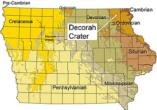
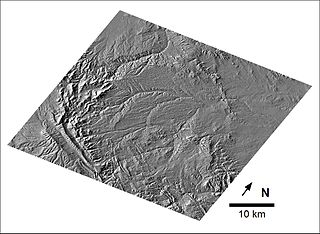
The Decorah crater, also called the Decorah impact structure, is a possible impact crater located on the east side of the city of Decorah in Iowa, United States. It is thought to have been caused by a meteor about 200 metres (660 ft) wide which struck during the Middle Ordovician Period, circa 470 million years ago.
The Bow City crater is a potential meteorite impact crater located in southern Alberta, Canada.
Cerro do Jarau crater is a 13.5 kilometres (8.4 mi) diameter circular feature in the Paraná Basin, Rio Grande do Sul in southern Brazil, close to the border with Uruguay. The Russian Academy of Sciences lists the structure as a probable impact crater.
Praia Grande crater is a 20 kilometres (12 mi) diameter circular feature in the Santos Basin offshore Brazil. It is a possible impact crater that has been identified on 3D seismic by Petrobras in 2004. Further investigation is needed to obtain more information on the structure. The Russian Academy of Sciences lists the structure as a probable impact crater.
Piratininga crater is a 12 kilometres (7.5 mi) diameter circular feature in the Paraná Basin of São Paulo State in Brazil. It is a possible impact crater, but further investigation is needed to obtain more information on the structure. The Russian Academy of Sciences listed the structure as a probable impact crater in 2017, but as questionable in 2019.