Related Research Articles
Alicel is an unincorporated community in the Sand Ridge area of the Grande Ronde Valley in Union County, Oregon, United States. It is northeast of La Grande on Oregon Route 82. It was a station on Union Pacific Railroad's Joseph branch, and in 1890 was named for Alice Ladd, wife of local resident Charles Ladd. Alicel was platted in 1890, and had a post office from 1890 until 1972.
Arock is an unincorporated rural hamlet in Malheur County, Oregon, United States. It is part of the Ontario, OR–ID Micropolitan Statistical Area. There is a post office and K-8 school in Arock, and Jordan Creek flows near Arock and joins the Owyhee River just west of Arock.

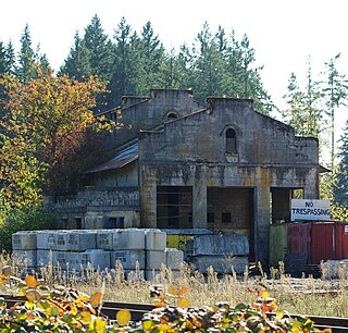
Brogan is an unincorporated community and Census-designated place (CDP) in Malheur County, Oregon, United States, on U.S. Route 26. Brogan was founded by D. M. Brogan in 1909, and when a post office was established in the locality on April 23 that year, it was named for him. Brogan is located on the north end of the now-abandoned Union Pacific Railroad branch line from Vale.

Hilgard is an unincorporated community in Union County, Oregon, United States, at the junction of Oregon Route 244 with Interstate 84/U.S. Route 30, near the Grande Ronde River. It is also the site of a junction (wye) of the Union Pacific Railroad. Hilgard Junction State Recreation Area is across the river from the community.
Nibley is an unincorporated historic community in Union County, Oregon, United States, about 11 miles east of La Grande on Oregon Route 237 in the Grande Ronde Valley.
Macleay is an unincorporated community in Marion County, Oregon, United States, about nine miles east of downtown Salem in the Waldo Hills near the Little Pudding River.

McCredie Springs are hot springs and a former resort in Lane County, Oregon, United States. It is located near Oregon Route 58, 10.7 miles (17.2 km) east of Oakridge, and 50.7 miles (81.6 km) east of Eugene, within the Willamette National Forest. It is known for the nearby natural hot springs along Salt Creek.
Nolin is an unincorporated community in Umatilla County, Oregon, United States. Nolin is about 8 miles (13 km) southeast of Echo, next to the Umatilla River. At one time the area was known as "Happy Canyon". Adam "Ad" W. Nye, a settler of the 1860s, named the Nolin area Happy Canyon, for the spirit of the people who lived there. The name was later adopted by Pendleton Round-Up for its indoor show in commemoration of this time. Nye was County Sheriff in 1872–74. The nearby community of Nye was named for him.
Tonquin is an unincorporated locale in Washington County, Oregon, United States.
Saint Joseph is an unincorporated community in Yamhill County, Oregon, United States. It is located about two miles west of Lafayette near Oregon Route 99W. The area is sometimes known as "St. Joe".
Tiernan is an unincorporated community in Lane County, Oregon, United States. It is about five miles west of Mapleton on Oregon Route 126 near the Siuslaw River and within the Siuslaw National Forest.
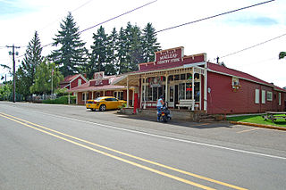
Willowcreek is an unincorporated village in Malheur County, Oregon, United States. It is about 11 miles (18 km) northwest of Vale on U.S. Route 26. The village has a combined store and café, and the region's elementary school. Willowcreek is located at 44.114605°N 117.364349°W. Today Willowcreek has a Vale mailing address, although the nearest post office is in nearby Jamieson.
Walker is an unincorporated community in Lane County, Oregon, United States. It is located about 4 miles (6 km) north of Cottage Grove on Oregon Route 99, near the Coast Fork Willamette River.
Dodson is an unincorporated community in Multnomah County, Oregon, United States. It is located about 4½ miles (7.2 km) east of Multnomah Falls and one mile west of Warrendale, in the Columbia River Gorge on Interstate 84/U.S. Route 30. It is across the Columbia River from Skamania, Washington. Dodson is within the Cascade Locks ZIP code.
Kamela is an unincorporated community in Union County, Oregon, United States. It is located west of Interstate 84 about 20 miles northwest of La Grande.
Crowley is an unincorporated community in Polk County, Oregon, United States. It is located east of Oregon Route 99W, about four miles north of Rickreall.
Cascade Summit is an unincorporated community in Klamath County, Oregon, United States. It is located on the west shore of Odell Lake near Shelter Cove; about 30 miles southeast of Oakridge.
Venator is an unincorporated community in Harney County, Oregon, United States. It is on Crane–Venator Road about 17 miles (27 km) southeast of Crane, near the South Fork Malheur River.
Hampton is an unincorporated locale in Lane County, Oregon, United States. It is located about 13 miles (21 km) southeast of Lowell. Hampton was established in 1952 as a station on the Southern Pacific Railroad Cascade Line on the shore of Lookout Point Lake, when the railroad was relocated because of the creation of the lake. It was named for Harry A. Hampton, the railroad division engineer from 1922 to 1943.
Tallman is a ghost town in Linn County, in the U.S. state of Oregon. It is located northwest of Lebanon.
References
- ↑ "Jonesboro (historical)". Geographic Names Information System . United States Geological Survey, United States Department of the Interior. November 28, 1980. Retrieved January 29, 2012.
- 1 2 3 4 McArthur, Lewis A.; McArthur, Lewis L. (2003) [1928]. Oregon Geographic Names (7th ed.). Portland, Oregon: Oregon Historical Society Press. p. 517. ISBN 978-0875952772.
- ↑ Oregon Atlas & Gazetteer (7th ed.). Yarmouth, Maine: DeLorme. 2008. pp. 82–83. ISBN 0-89933-347-8.
- ↑ "Oregon Eastern Division: WYCO Scrap Trains". High Desert Rails. trainweb.org. Retrieved January 29, 2012.
