Joppa, Illinois

Last updated

Joppa, Illinois
Joppa-from-East-il.jpg
Joppa
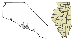
Massac County Illinois Incorporated and Unincorporated areas Joppa Highlighted.svg
Location in Massac County, Illinois
Usa edcp location map.svg
Red pog.svg
Massac
Location in the United States
Coordinates: 37°12′27″N88°50′35″W / 37.20750°N 88.84306°W / 37.20750; -88.84306
CountryUnited States
StateIllinois
County Massac
Area
[1]
  Total0.50 sq mi (1.31 km2)
  Land0.49 sq mi (1.26 km2)
  Water0.02 sq mi (0.05 km2)
Elevation
355 ft (108 m)
Population
 (2020) [2]
  Total350
  Density720.16/sq mi (278.17/km2)
Time zone UTC-6 (CST)
  Summer (DST) UTC-5 (CDT)
ZIP code
62953
Area code 618
FIPS code 17-38674
Wikimedia CommonsJoppa, Illinois

Joppa is a village in Massac County, Illinois, United States, along the Ohio River. The population was 350 as of the 2020 census. [2] It is part of the Paducah, KY-IL Metropolitan Statistical Area.

Contents

History

During the first part of the 19th century, a riverboat landing known as Copeland's Landing operated at what is now Joppa. In the early 1870s, A.J. Kuykendall, a prominent local land owner, and Jesse Baccus, who operated a local sawmill, decided to establish a town. They named the town after the Biblical city of Joppa (in modern Israel). After the arrival of the railroad in 1900, the village thrived for several years as a river-to-rail transloading station. Joppa incorporated in 1901. [3] Joppa has since lost a lot of population and stores, now only having a school and a few hundred people living there.

Geography

Joppa is located in western Massac County at 37°12′27″N88°50′35″W / 37.20750°N 88.84306°W / 37.20750; -88.84306 (37.207399, -88.843033). [4] The village lies along the Ohio River downstream from Metropolis, Illinois, and Paducah, Kentucky. Metropolis is 8 miles (13 km) southeast of Joppa, and Paducah is 20 miles (32 km) to the southeast. County Road 5 connects Joppa with U.S. Route 45 near Metropolis to the east. The Joppa Generating Station, a coal and natural gas power plant operated by Electric Energy, Inc., lies just west of the village.

According to the U.S. Census Bureau, Joppa has a total area of 0.50 square miles (1.29 km2), of which 0.02 square miles (0.05 km2), or 3.57%, are water. [1]

Demographics

Historical population
CensusPop.Note
1910 734
1920 651−11.3%
1930 462−29.0%
1940 58727.1%
1950 513−12.6%
1960 57812.7%
1970 531−8.1%
1980 5350.8%
1990 492−8.0%
2000 409−16.9%
2010 360−12.0%
2020 350−2.8%
U.S. Decennial Census [5]

2010

According to the 2010 U.S. Census Bureau, 360 persons lived in the village:

2000

In 2000, there were 409 people, 165 households, and 110 families residing in the village. [6] The population density was 838.2 inhabitants per square mile (323.6/km2). There were 203 housing units at an average density of 416.0 per square mile (160.6/km2). The racial makeup of the village was 88.26% White, 7.58% African American, 0.24% Native American, 0.98% from other races, and 2.93% from two or more races. Hispanic or Latino of any race were 2.44% of the population.

There were 165 households, out of which 32.1% had children under the age of 18 living with them, 48.5% were married couples living together, 12.7% had a female householder with no husband present, and 33.3% were non-families. 28.5% of all households were made up of individuals, and 8.5% had someone living alone who was 65 years of age or older. The average household size was 2.48 and the average family size was 3.09.

In the village, the population was spread out, with 27.6% under the age of 18, 8.3% from 18 to 24, 24.4% from 25 to 44, 26.9% from 45 to 64, and 12.7% who were 65 years of age or older. The median age was 36 years. For every 100 females, there were 109.7 males. For every 100 females age 18 and over, there were 96.0 males.

The median income for a household in the village was $17,813, and the median income for a family was $20,729. Males had a median income of $23,750 versus $16,607 for females. The per capita income for the village was $8,890. About 34.3% of families and 44.6% of the population were below the poverty line, including 65.1% of those under age 18 and 20.0% of those age 65 or over.

See also

Related Research Articles

<span class="mw-page-title-main">McCracken County, Kentucky</span> County in Kentucky, United States

McCracken County is a county located in the far west portion of U.S. state of Kentucky. As of the 2020 census, the population was 67,875. The county seat and only municipality is Paducah. McCracken County was the 78th county formed in the state, having been created in 1825. It is part of the historic Jackson Purchase, territory sold by the Chickasaw people to General Andrew Jackson and Governor Isaac Shelby; this territory was located at the extreme western end of Kentucky.

<span class="mw-page-title-main">Livingston County, Kentucky</span> County in Kentucky, United States

Livingston County is a county located in the U.S. state of Kentucky. As of the 2020 census, the population was 8,888. Its county seat is Smithland and its largest community is Ledbetter. The county was established in 1798 from land taken from Christian County and is named for Robert R. Livingston, a member of the Committee of Five that drafted the U.S. Declaration of Independence. The county was strongly pro-Confederate during the American Civil War and many men volunteered for the Confederate Army. Livingston County is part of the Paducah, KY-IL Metropolitan Statistical Area. It is a prohibition or dry county with the exception of Grand Rivers which voted to allow alcohol sales in 2016.

<span class="mw-page-title-main">Massac County, Illinois</span> County in Illinois, United States

Massac County is a county in the U.S. state of Illinois. According to the 2020 census, it had a population of 14,169. Established in 1843 and named for a French fort founded in the 18th century, its county seat is Metropolis. Massac County is included in the Paducah, KY-IL Metropolitan Statistical Area. It is located along the Ohio River, in the portion of the state known locally as "Little Egypt".

<span class="mw-page-title-main">Deer Park, Illinois</span> Village in Illinois, United States

Deer Park is a village in Lake and Cook Counties, Illinois. Per the 2020 census, the population was 3,681. The village is one of the few left in the Chicago area that enjoy a green belt which is bordered by two large natural areas providing outdoor recreation and open space. The village is home to popular shopping and dining destinations: Deer Park Town Center and the Town Center Promenade. The town is also home to the Vehe Farm, an Illinois Centennial Farm.

<span class="mw-page-title-main">Thompsonville, Illinois</span> Village in Illinois, United States

Thompsonville is a village in Cave Township, Franklin County, Illinois, United States. The population was 486 at the 2020 census.

<span class="mw-page-title-main">Sun River Terrace, Illinois</span> Village in Illinois, United States

Sun River Terrace is a village in Kankakee County, Illinois, United States. The population was 455 at the 2020 census. It is included in the Kankakee-Bradley, Illinois Metropolitan Statistical Area.

Forest Lake is an unincorporated community and census-designated place (CDP) in Ela Township of Lake County, Illinois, United States. It is about 35 miles (56 km) northwest of downtown Chicago. Per the 2020 census, the population was 1,784. The community was founded in 1935 as a vacation community for Chicago residents.

Lake Catherine is an unincorporated community and census-designated place (CDP) in Lake County, Illinois, United States. Per the 2020 census, the population was 1,279.

<span class="mw-page-title-main">Round Lake Heights, Illinois</span> Village in Illinois, United States

Round Lake Heights is a village in Lake County, Illinois, United States. Per the 2020 census, the population was 2,622.

<span class="mw-page-title-main">Brookport, Illinois</span> City in Illinois, United States

Brookport is a city in Massac County, Illinois, United States. The population was 725 at the 2020 census, down from 984 in 2010. It is part of the Paducah, KY-IL Metropolitan Statistical Area.

<span class="mw-page-title-main">Metropolis, Illinois</span> City in Illinois, United States

Metropolis is a city located along the Ohio River in Massac County, Illinois, United States. As of the 2020 census, it had a population of 5,969, down from 6,537 in 2010. Metropolis is the county seat of Massac County and is part of the Paducah, KY-IL Micropolitan Statistical Area in Southern Illinois.

<span class="mw-page-title-main">Lakewood, Illinois</span> Village in Illinois, United States

The Village of Lakewood is a village in McHenry County, Illinois, United States. It was incorporated as a village on July 10, 1933. Per the 2020 census, the population was 4,283. Although commonly referred to as Lakewood, the town's proper name is preceded by 'The Village of'.

<span class="mw-page-title-main">Oakwood Hills, Illinois</span> Village in Illinois, United States

Oakwood Hills is a village in McHenry County, Illinois, United States. It was founded in 1959. The population was 2,076 at the 2020 census.

<span class="mw-page-title-main">Spring Grove, Illinois</span> Village in Illinois, United States

Spring Grove is a village in McHenry County. Portions of unincorporated Lake County, Illinois also utilize Spring Grove postal addresses. It is a commuter village within the Chicago metropolitan area. Per the 2020 census, the population was 5,487. It is also home to Chain O'Lakes State Park.

<span class="mw-page-title-main">Hendron, Kentucky</span> Census-designated place in Kentucky, United States

Hendron is an unincorporated community and census-designated place (CDP) in McCracken County, Kentucky, United States. The population was 4,774 at the 2020 census. It is part of the Paducah, KY-IL Metropolitan Statistical Area.

<span class="mw-page-title-main">Lone Oak, Kentucky</span> Unincorporated community in Kentucky, United States

Lone Oak is an unincorporated community and former city in McCracken County, Kentucky, United States. The population was 454 at the 2000 census, the last before its disincorporation. It is a part of the Paducah, KY-IL Metropolitan Statistical Area.

<span class="mw-page-title-main">Massac, Kentucky</span> Census-designated place in Kentucky, United States

Massac is a census-designated place (CDP) in McCracken County, Kentucky, United States. The population was 4,635 at the 2020 census. It is part of the Paducah, KY-IL Metropolitan Statistical Area.

Reidland is an unincorporated community and census-designated place (CDP) in McCracken County, Kentucky, United States. The population was 4,526 at the 2020 census. It is part of the Paducah, KY-IL Metropolitan Statistical Area.

<span class="mw-page-title-main">Tower Lakes, Illinois</span> Village in Illinois, United States

Tower Lakes is a village in Lake County, Illinois, United States. Per the 2020 census, the population was 1,226.

<span class="mw-page-title-main">Paducah micropolitan area</span> Metropolitan Area in Western Kentucky

The Paducah, KY–IL Metropolitan Statistical Area, as defined by the United States Census Bureau, is an area consisting of five counties – three in the Jackson Purchase region of Kentucky, a fourth Kentucky county bordering the Purchase, and one in Southern Illinois – anchored by the city of Paducah, Kentucky. The Paducah KY-IL Micropolitan Statistical Area was upgraded to Metropolitan Statistical Area (MSA) status on July 21, 2023, by the Office of Management and Budget.. Carlisle County, Kentucky, was added to the area following the 2020 Census of the Population. The total MSA population from the 2020 United States Census was 103,486.

References

  1. 1 2 "2022 U.S. Gazetteer Files: Illinois". United States Census Bureau. Retrieved March 1, 2023.
  2. 1 2 "P1. Race – Joppa village, Illinois: 2020 DEC Redistricting Data (PL 94-171)". U.S. Census Bureau. Retrieved March 1, 2023.
  3. George W. May, History of Massac County, Illinois (Wagoner Printing Company, 1955), pp. 192-194. Accessed at archive.org.
  4. "US Gazetteer files: 2010, 2000, and 1990". United States Census Bureau. February 12, 2011. Retrieved April 23, 2011.
  5. "Census of Population and Housing". Census.gov. Retrieved June 4, 2015.
  6. "U.S. Census website". United States Census Bureau . Retrieved January 31, 2008.