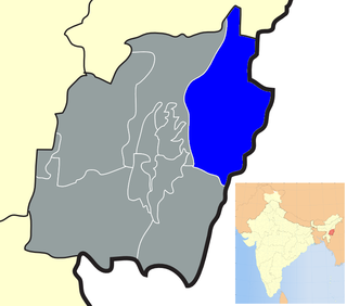
Sirarakhong also called as Kampha is a village located west of Ukhrul in Ukhrul district, Manipur state, India. As per 2011 census, the village has a total of 202 households with 1243 persons of which 620 are male while 623 are female. Of the total population, 10.86% are in the age group of 0–6 years. The average sex ratio of the village is 1015 female per 1000 male which is higher thaln the state's average of 930. The literacy rate of the village is 95.22%.Neighbouring villages of Teinem are Tungou, Lambui, Sinakeithei Tushen and Tanrui.
Ngainga also called Ngaimu is a village located west of Ukhrul in Ukhrul district, Manipur state, India. The village is approximately 17 kilometers from Ukhrul. As per 2011 census, the village has a total of 267 households with 2881 persons of which 964 are male while 917 are female. Of the total population, 323 are in the age group of 0–6 years. The average sex ratio of the village is 1015 female per 1000 male which is higher thaln the state's average of 930. The literacy rate of the village is 92.22%. Neighbouring villages of Ngainga are Seikhor, Tolloi, Phalee Somdal and Tuinem. Ngainga is the birthplace of Luingamla who was shot dead on 24 January 1986 by Indian army personnel for resisting their attempt to rape her.
Phungcham is a village located north of Ukhrul in Ukhrul district, Manipur state, India. The village is approximately 28 kilometers from Ukhrul and is connected by inter village road constructed under PMGSY. Phungcham is flanked by Longpi and Lunghar in the east, Peh in the north, Ukhrul and Halang in the south and Talui in the west.
Chingjaroi, originally known Asinei or Asewnei alternatively called Zingchui/Zingjui by the tangkhul ,Swemi by the Poumai and khatsomi by the Chakhesang tribe is a large tangkhul Naga village located north of Ukhrul in Ukhrul district, Manipur state, India and bordered mainly by villages like Peh, Phaibung ,Jessami, Laii ,Kharasom and Razai. The village is sub-divided into three parts, viz. Chingjaroi Khullen, Chingjaroi Khunou and Chingjaroi Christian Village. Chingjaroi Khullen the nearest from the National Highway 150 is approximately 84 kilometers from Ukhrul district headquarters.
Chingai is a village located north of Ukhrul in Ukhrul district, Manipur state, India. The village is one of the seven sub-divisional headquarters of Ukhrul district. The village partially connected by National Highway 150, Imphal-Kohima road via Jessami. Chingai is also one of the 60 Vidhan Sabha constituencies of Manipur and MK Preshow Shimray is the incumbent Member of Ligislative Assembly (MLA) elected from this constituency. The village is flanked by Awang Kasom in the west, Khamasom in the south, Somrah Tract in the east and Kharasom in the north.
Kharasom is a village located north of Ukhrul in Ukhrul district, Manipur state, India. The village is fully connected by National Highway 150, Imphal-Kohima road via Jessami. It is 85 km from the District headquarters and approximately 170 km from the state capital Imphal. Kharasom is flanked by Chingjaroi and Razai Khunou in the south, Laii in the west, Wahong and Soraphung to its Northeast, Tusom in the East and Jessami to its north.
Tusom is a generic reference to two villages located north of Ukhrul in Ukhrul district, Manipur state, India. The villages are Tusom Khullen or New Tusom and Tusom CV. The villages are partially connected by National Highway 150, Imphal-Kohima road via Jessami. Tusom is 120 kilometres away from Ukhrul and about 5 kilometres away from Indo-Myanmar border pillar number 130. Tusom is flanked by Kharasom in the west, Chingai in the south and Laivum village Myanmar in the east. The dialect spoken by the inhabitants of Tusom belongs to the Sorbung language family.
Poi is a village located north of Ukhrul in Ukhrul district, Manipur state, India. The village is partially connected by National Highway 150, Imphal-Kohima road via Jessami. Poi is 68 kilometers away from Ukhrul via Awangkasom and about 3 kilometers and 5 kilometers away from Indo-Myanmar border pillar number 126 and 130 respectively. Poi is flanked by Challou in the North, Chingai in the north west, Ngahui, Kuirei and Marem in the west, Huishu and Khamasom in the south. MK Preshow Shimray, the Ex- MLA from Chingai Assembly Constituency and also the Deputy Speaker of the present Manipur Legislative Assembly hails from this village.
Kalhang is a village located north of Ukhrul in Ukhrul district, Manipur state, India. The village is approximately 39 kilometers from Ukhrul. National Highway 150 Imphal-Kohima via Jessami passes through the village. Kalhang is one of the villages that used to make indigenous salt from natural salt springs and supply to other Tangkhul villages before the introduction of common salt. The village is flanked by Phungcham and Peh in the west, Khamasom in the east, Longpi in the south and Kuirei in the North. Locally inhabitants speak Kansang dialect which belongs to the Tibeto-Burman language family.
Kuirei is a village located north of Ukhrul in Ukhrul district, Manipur state, India. The village is approximately 41 kilometers from Ukhrul. National Highway 150 Imphal-Kohima via Jessami passes through the village. Kuirei is one of the villages that used to make indigenous salt from salt springs and supply to other Tangkhul villages before the advent of common salt. The village is flanked by Phungcham and Peh in the west, Huishu and Khamasom in the east, Kalhang in the south and Ngahui and Marem in the North. Locally inhabitants speak Kuirei dialect which belongs to the Tibeto-Burman language family.
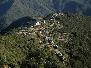
Shirui also misnomerly called 'Shiroy'/Shiroi is a village located north of Ukhrul in Ukhrul district, Manipur state, India. The village is 15 kilometers from Ukhrul. National Highway 150 Imphal-Kohima via Jessami passes through the village. The village is divided into two parts Shirui ato and Shirui aze, however, both the parts are under one chief. Shirui is famous for the rich and flora found on Shirui Kashong or Shirui peak and especially for blooming of the rare Lilium mackliniae during the start of Monsoon. The village is flanked by Ukhrul in the west, Langdang in the south, Mapum in the east, Sihai in the North east and Lunghar in the north. Locally inhabitants speak Shirui dialect which belongs to the Tibeto-Burman language family.
Langdang is a village located north of Ukhrul in Ukhrul district, Manipur state, India. The village is 13 kilometers from Ukhrul. National Highway 150 Imphal-Kohima via Jessami passes through the village. The village is divided into two major parts, Langdang Khullen and Langdang Phungthar; however, both the parts are under one chief. The village is famous for largescale plum cultivation. The village is flanked by Mapum in the east, Shirui in the north, Ukhrul in the west and Choithar in the south.
Shangshak is a generic reference to two villages viz. Shangshak Khullen and Shangshak Khunou located south of Ukhrul in Ukhrul district, Manipur state, India. The village is about 15 kilometers from Ukhrul via National Highway 150 and the state highway that connects Ukhrul-Kamjong via Shangshak. Shangshak is flanked by Hungpung in the north, Koso in the south, Ramva in the west and Gamnom and Yengtem in the east. The first battle in Indian soil during the Second World War between the Japanese and the allied forces was fought in Shangshak. The battle of Shangshak fought for two weeks from 21 to 26 March 1944 is considered as one of the bloodiest battles of the Second World War. Locally, the residents speak Shangshak dialect which belongs to the Tibeto-Burman language family.
Phungyar is a village located south of Ukhrul in Ukhrul district, Manipur state, India. The village is about 50 kilometers from Ukhrul and is partially connected by National Highway 150 that connects Imphal and Kohima via Ukhrul and Jessami. The village is flanked by Alang and Khambi in the south, Godah in the north and Kasom in the west. Locally, the inhabitants speak Phungyar tui which belongs to the Tibeto-Burman language family.
Langli is a village located southeast of Ukhrul in Ukhrul district, Manipur state, India. The village is about 60 kilometers from Ukhrul and is partially connected by Ukhrul-Kamjong State highway. The village is flanked by Maku in the north, Kamjong village in the south, the Chatric in the east and Apong in the west. The village is divided into two major parts with separate settlements; Langli K and R Langli.
Seikhor is a village located west of Ukhrul in Ukhrul district, Manipur state, India. The village falls under Ukhrul sub division. Seikhor is partially connected by the old Imphal-Ukhrul road and is about 18 kilometers from Ukhrul. Seikhor is flanked by Pharung in the east, Teinem in the west, Tashar in the south and Ngainga in the north. Locally, the inhabitants speak Seikhor dialect that belongs to the Tibeto-Burman language family.
Ningchou is a village located south of Ukhrul in Ukhrul district, Manipur state, India. The village falls under Kamjong sub division. Ningchou is connected by Ukhrul-Kamjong state highway. The village is flanked by Patbung in the west, Nambisha in the south, Kongkan in the east and Kamjong in the north. Locally, the inhabitants speak Ningchou dialect that belongs to the Tibeto-Burman language family. Some researchers are of the view that the dialect spoken by the inhabitants has some affinity to that of the Koireng tribe.
Kangpat is a generic reference to two villages, Kangpat Khullen and Kangpat Khunou located south of Ukhrul in Ukhrul district, Manipur state, India. The village falls under Kamjong sub division. The two villages are connected by Ukhrul-Kamjong state highway. Kangpat is flanked by Sorbung in the west, Choro in the south, Skipe in the east and Nambisha in the north. Locally, the inhabitants speak Kangpat dialect that belongs to the Tibeto-Burman language family. Some researchers are of the view that the dialect spoken by the inhabitants has some affinity to that of the Koireng tribe.
Skipe is a border village on the side of India in the Indo-Myanmar international border. The village is located south of Ukhrul in Ukhrul district, Manipur state, India. Skipe falls under Kamjong sub division. The village is partially connected by Ukhrul-Kamjong state highway. Skipe is flanked by Chindwin river in the east, Konkan Thana in the north, Kangpat in the west and Namlee in the south. Locally, the inhabitants speak Skipe dialect that belongs to the Tibeto-Burman language family. Some researchers are of the view that the dialect spoken by the inhabitants has some affinity to that of the Koireng tribe.
Khamlang village is situated on the southern part of Ukhrul District, Manipur, India. It is inhabited by Khameon a Tangkhul Naga tribe. It is situated 2 km away from headquarter of Sub-Division, Kasom Khullen, 137 km away from district headquarter Ukhrul and 59 km from state capital Imphal, Manipur.