Sihai is a general reference to a group of villages in the north of Ukhrul District headquarters in Manipur. Sihai Khullen, the nearest from Ukhrul is about 37 kilometers from Ukhrul, connected partially by National Highway 150.
Chingjaroi originally known Asinei /Asewnei or Swemi alternatively called Zingchui/Zingjui by the Tangkhul, Shomai by the Poumai and khotsami by the Chakhesangs is a large village located in northern Ukhrul district, Manipur state, India and bordered mainly by villages like Jessami, Tasom, Chingai, Marem, Peh, Phaibung and Laii (Gaziphema)originally. Later villages like Razai, Namrei and Kharasom came to settle in the land of chingjaroi and became its neighboring villages. The village consists of three sister villages, namely, Chingjaroi Khullen, Chingjaroi Khunou and Chingjaroi Christian Village. Chingjaroi Khullen the nearest from the National Highway 150 is approximately 84 kilometers from Ukhrul district headquarters.
Kharasom is a village located north of Ukhrul in Ukhrul district, Manipur state, India. The village is fully connected by National Highway 150, Imphal-Kohima road via Jessami. It is 85 km from the District headquarters and approximately 170 km from the state capital Imphal. Kharasom is flanked by Chingjaroi and Razai Khunou in the south, Laii in the west, Wahong and Soraphung to its Northeast, Tusom in the East and Jessami to its north.
Wahong is a small village located north of Ukhrul in Ukhrul district, Manipur state, India. The village partially connected by National Highway 150, Imphal-Kohima road via Jessami. The village is 130 kilometers away from Ukhrul and about 10 kilometers away from Indo-Myanmar border pillar number 130. Wahong is flanked by Kharasom in the west, Tusom in the south and Nagaland in the east and north.
Poi is a village located north of Ukhrul in Ukhrul district, Manipur state, India. The village is partially connected by National Highway 150, Imphal-Kohima road via Jessami. Poi is 68 kilometers away from Ukhrul via Awangkasom and about 3 kilometers and 5 kilometers away from Indo-Myanmar border pillar number 126 and 130 respectively. Poi is flanked by Challou in the North, Chingai in the north west, Ngahui, Kuirei and Marem in the west, Huishu and Khamasom in the south. MK Preshow Shimray, the Ex- MLA from Chingai Assembly Constituency and also the Deputy Speaker of the present Manipur Legislative Assembly hails from this village.
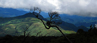
Shirui, initially called Shiroy/Shiroi, is a village located north of Ukhrul in Ukhrul district, Manipur state, India. The village is 15 kilometers from Ukhrul. National Highway 150 Imphal-Kohima via Jessami passes through the village. The village is divided into two parts, Shirui ato and Shirui aze; however, both the parts are under one chief. Shirui is famous for the rich and flora found on Shirui Kashong or Shirui peak and especially for blooming of the rare Lilium mackliniae during the start of Monsoon. The village is flanked by Ukhrul in the west, Langdang in the south, Mapum in the east, Sihai in the North east and Lunghar in the north. Locally inhabitants speak Shirui dialect which belongs to the Tibeto-Burman language family.
Langdang is a village located north of Ukhrul in Ukhrul district, Manipur state, India. The village is 13 kilometers from Ukhrul. National Highway 150 Imphal-Kohima via Jessami passes through the village. The village is divided into two major parts, Langdang Khullen and Langdang Phungthar; however, both the parts are under one chief. The village is famous for largescale plum cultivation. The village is flanked by Mapum in the east, Shirui in the north, Ukhrul in the west and Choithar in the south.
Nungshong Khullen is located south of Ukhrul in Ukhrul district, Manipur state, India. The village is about 30 kilometers from Ukhrul via the state highway that connects Ukhrul-Kamjong via Shangshak. The shorter un-metalled road from Ukhrul to Nungshong khullen is about 15 kilometers. Construction of a new road under PMGSY to connect the neighboring villages with Ukhrul is underway for which there were reports of irregularities on the part of the executing agencies. Nungshong is flanked by Hungpung in the west, Shangching in the south, Choithar and Khangkhui in the north. Locally, the residents speak Nungshong dialect which belongs to the Tibeto-Burman language family.

Shangshak is a generic reference to two villages viz. Shangshak Khullen and Shangshak Khunou located south of Ukhrul in Ukhrul district, Manipur state, India. The village is about 15 kilometers from Ukhrul via National Highway 150 and the state highway that connects Ukhrul-Kamjong via Shangshak. Shangshak is flanked by Hungpung in the north, Koso in the south, Ramva in the west and Gamnom and Yengtem in the east. Locally, the residents speak Shangshak dialect which belongs to the Tibeto-Burman language family.
Tungou also misnomerly referred to as Ringui is a village located south of Ukhrul in Ukhrul district, Manipur state, India. The village is about 35 kilometers from Ukhrul via National Highway 150 that connects Imphal and Kohima via Ukhrul and Jessami. Tungou is flanked by Ramva in the east, Tashar in the north, Sinakeithei in the west and Lungpha in the south. Locally, the inhabitants speak Tungou tui which belongs to the Tibeto-Burman language family.
Lungshang is a small village located south of Ukhrul in Ukhrul district, Manipur state, India. The village is about 20 kilometers from Ukhrul partially connected by National Highway 150 that connects Imphal and Kohima via Ukhrul and Jessami. Lungshang is divided into two major parts, Lungshang Azing and Lungshang Ato and is flanked by Shangshak in the south, Nungshong in the west, Yengtem in the east and Khangkhui in the north. Locally, the inhabitants speak Lungshang tui which belongs to the Tibeto-Burman language family.
Tangkhul Hundung is a village south of Ukhrul in Ukhrul district, Manipur, India. The village is about 65 kilometres (40 mi) from Ukhrul and about 45 kilometres (28 mi) from Imphal and is partially connected by National Highway 150 that connects Imphal and Kohima via Ukhrul and Jessami. Tangkhul Hundung is divided into two major parts, Tangkhul Hundung Khullen and Tangkhul Hundung Khunou. The village is flanked by Thoyee in the west, Shingkap in the north, Itham in the south and Alang in the east. Locally, the inhabitants speak Tangkhul Hundung tui, which belongs to the Tibeto-Burman language family.
Chatric, also known as Siyang, is a village located southeast of Kamjong in Kamjong district, Manipur state, India. The village is about 40 kilometers from Kamjong and is partially connected by Ukhrul-Kamjong state highway. The village is flanked by Chamu in the north, Chahong village in the south, the Chindwin river (Myanmar) in the east and Chahong in the west.
Ningthi is a village located west of Kamjong in Kamjong district, Manipur state, India. The village is about 20 kilometers from Kamjong and is partially connected by Ukhrul-Kamjong State highway and inter village road constructed in 2015. Ningthi is flanked by Kamjong in the east, Phungyar in the west, Tusom in the south and Hangkau in the north. Ningthi river is the main tributary of Chindwin river of Myanmar.
Bungpa is a generic reference to two villages, Bungpa Khullen and Bungpa Khunou located south of Ukhrul in Ukhrul district, Manipur state, India. The village falls under Kamjong sub division. The villages are connected by Ukhrul-Kamjong state highway. Bungpa is flanked by Phungyar in the west, Grihang in the south, Lakhan in the east and Kamjong in the north. Locally, the inhabitants speak Bungpa dialect that belongs to the Tibeto-Burman language family.
Grihang is a village located south of Ukhrul in Ukhrul district, Manipur state, India. The village falls under Kamjong sub division. The village is connected by Ukhrul-Kamjong state highway. Grihang is flanked by Tusom in the west, Ningchou in the south, Molvailup in the east and Bungpa in the north. Locally, the inhabitants speak Grihang dialect that belongs to the Tibeto-Burman language family.
Kangpat is a generic reference to two villages, Kangpat Khullen and Kangpat Khunou located south of Ukhrul in Ukhrul district, Manipur state, India. The village falls under Kamjong sub division. The two villages are connected by Ukhrul-Kamjong state highway. Kangpat is flanked by Sorbung and Punge in the west, Choro in the south, Skipe in the east and Nambisha in the north. Locally, the inhabitants speak Kangpat dialect that belongs to the Tibeto-Burman language family. Some researchers are of the view that the dialect spoken by the inhabitants has some affinity to that of the Koireng tribe.
Skipe is a border village on the side of India in the Indo-Myanmar international border. The village is located south of Ukhrul in Ukhrul district, Manipur state, India. Skipe falls under Kamjong sub division. The village is partially connected by Ukhrul-Kamjong state highway. Skipe is flanked by Chindwin river in the east, Konkan Thana in the north, Kangpat in the west and Namlee in the south. Locally, the inhabitants speak Skipe dialect that belongs to the Tibeto-Burman language family. Some researchers are of the view that the dialect spoken by the inhabitants has some affinity to that of the Koireng tribe.
Nungbi Khullen, locally called Loree, is a village north of Ukhrul in Ukhrul district of Manipur state, India. It is part of the Chingai subdivision. National Highway 150, connecting Imphal-Kohima via Ukhrul and Jessami, passes through it. About 35 kilometers from Ukhrul, it is flanked by Loree Kaju to the west, Lunghar to the south, Khamasom to the east and Kalhang to the north. Its inhabitants speak the Loree dialect of the Tibeto-Burman language family.
Razai is a generic reference two villages, Razai Khullen and Razai Khunou Ukhrul in Ukhrul district, Manipur state, India. The village falls under Chingai sub division. National Highway 150 that connects Imphal-Kohima via Ukhrul and Jessami passes through the village. Razai is about 50 kilometers from Ukhrul; and is flanked by Peh in the west, Awang Kasom in the south, Chingai in the east and Maremphung in the north. Locally, the inhabitants speak Razai dialect that belongs to the Tibeto-Burman language family.

