
Ukhrul district is an administrative district of the state of Manipur in India with its headquarters at Ukhrul. The Ukhrul district has a long history dating back to the 1920s when it was created as the North-East Hill Sub-Division of the then princely state of Manipur. In 2016, the Kamjong subdivision of the Ukhrul district was spun out as a separate district, leading to the present configuration of the Ukhrul district.
Sihai is a general reference to a group of villages in the north of Ukhrul District headquarters in Manipur. Sihai Khullen, the nearest from Ukhrul is about 37 kilometers from Ukhrul, connected partially by National Highway 150.
Sirarakhong also called as Kampha is a village located west of Ukhrul in Ukhrul district, Manipur state, India. As per 2011 census, the village has a total of 202 households with 1243 persons of which 620 are male while 623 are female. Of the total population, 10.86% are in the age group of 0–6 years. The average sex ratio of the village is 1015 female per 1000 male which is higher than the state's average of 930. The literacy rate of the village is 95.22%.
Phungcham is a village located north of Ukhrul in Ukhrul district, Manipur state, India. The village is approximately 28 kilometers from Ukhrul and is connected by inter village road constructed under PMGSY. Phungcham is flanked by Longpi and Lunghar in the east, Peh in the north, Ukhrul and Halang in the south and Talui in the west.
Chingai is a village located north of Ukhrul in Ukhrul district, Manipur state, India. The village is one of the seven sub-divisional headquarters of Ukhrul district. The village partially connected by National Highway 150, Imphal-Kohima road via Jessami. Chingai is also one of the 60 Vidhan Sabha constituencies of Manipur and Khashim Vashum is the Member of Ligislative Assembly (MLA) elected from this constituency & Minister of 1.Animal Husbandry & Veterinary Dept. 2. Transportation dept. of government of Manipur.[ The village is flanked by Awang Kasom in the west, Khamasom in the south, Somrah Tract in the east and Kharasom in the north.
Kharasom is a village located north of Ukhrul in Ukhrul district, Manipur state, India. The village is fully connected by National Highway 150, Imphal-Kohima road via Jessami. It is 85 km from the District headquarters and approximately 170 km from the state capital Imphal. Kharasom is flanked by Chingjaroi and Razai Khunou in the south, Laii in the west, Wahong and Soraphung to its Northeast, Tusom in the East and Jessami to its north.
Poi is a village located north of Ukhrul in Ukhrul district, Manipur state, India. The village is partially connected by National Highway 150, Imphal-Kohima road via Jessami. Poi is 68 kilometers away from Ukhrul via Awangkasom and about 3 kilometers and 5 kilometers away from Indo-Myanmar border pillar number 126 and 130 respectively. Poi is flanked by Challou in the North, Chingai in the north west, Ngahui, Kuirei and Marem in the west, Huishu and Khamasom in the south. MK Preshow Shimray, the Ex- MLA from Chingai Assembly Constituency and also the Deputy Speaker of the present Manipur Legislative Assembly hails from this village.
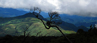
Shirui, initially called Shiroy/Shiroi, is a village located north of Ukhrul in Ukhrul district, Manipur state, India. The village is 15 kilometers from Ukhrul. National Highway 150 Imphal-Kohima via Jessami passes through the village. The village is divided into two parts, Shirui ato and Shirui aze; however, both the parts are under one chief. Shirui is famous for the rich and flora found on Shirui Kashong or Shirui peak and especially for blooming of the rare Lilium mackliniae during the start of Monsoon. The village is flanked by Ukhrul in the west, Langdang in the south, Mapum in the east, Sihai in the North east and Lunghar in the north. Locally inhabitants speak Shirui dialect which belongs to the Tibeto-Burman language family.
Langdang is a village located north of Ukhrul in Ukhrul district, Manipur state, India. The village is 13 kilometers from Ukhrul. National Highway 150 Imphal-Kohima via Jessami passes through the village. The village is divided into two major parts, Langdang Khullen and Langdang Phungthar; however, both the parts are under one chief. The village is famous for largescale plum cultivation. The village is flanked by Mapum in the east, Shirui in the north, Ukhrul in the west and Choithar in the south.
Choithar (Rithar) is a village located east of Ukhrul in Ukhrul district, Manipur state, India. The village is 12 kilometers from Ukhrul. National Highway 150 Imphal-Kohima via Jessami partially connects the village. The village is about 6 kilometers from the National highway connected earlier by an old British road. There was a proposal to construct a new road under PMGSY for which there were reports of discrepancies on the part of the executing agencies. Choithar is flanked by Ukhrul in the west, Choithar in the north, Nungshong in the south and Khangkhui in the east.
Nungshong Khullen is located south of Ukhrul in Ukhrul district, Manipur state, India. The village is about 30 kilometers from Ukhrul via the state highway that connects Ukhrul-Kamjong via Shangshak. The shorter un-metalled road from Ukhrul to Nungshong khullen is about 15 kilometers. Construction of a new road under PMGSY to connect the neighboring villages with Ukhrul is underway for which there were reports of irregularities on the part of the executing agencies. Nungshong is flanked by Hungpung in the west, Shangching in the south, Choithar and Khangkhui in the north. Locally, the residents speak Nungshong dialect which belongs to the Tibeto-Burman language family.

Shangshak is a generic reference to two villages viz. Shangshak Khullen and Shangshak Khunou located south of Ukhrul in Ukhrul district, Manipur state, India. The village is about 15 kilometers from Ukhrul via National Highway 150 and the state highway that connects Ukhrul-Kamjong via Shangshak. Shangshak is flanked by Hungpung in the north, Koso in the south, Ramva in the west and Gamnom and Yengtem in the east. Locally, the residents speak Shangshak dialect which belongs to the Tibeto-Burman language family.
Tashar, also known as Tushar or Tushen, is a generic reference to two villages viz. Tashar and Tashar Chanhong located south-west of Ukhrul in Ukhrul district, Manipur state, India. The village is about 18 kilometers from Ukhrul via National Highway that connects Imphal and Kohima via Ukhrul and Jessami. Tashar is flanked by Pharung in the north, Ramva in the south, Shangshak in the east and Sirarakhong in the West. The village is divided into two major parts, Tashar main and Tashar Chanhong. Locally, the inhabitants speak Tashar tui which belongs to the Tibeto-Burman language family.
Ramva also misnomerly called as Lambui is a village located south of Ukhrul in Ukhrul district, Manipur state, India. The village is about 25 kilometers from Ukhrul via National Highway 150 that connects Imphal and Kohima via Ukhrul and Jessami. Ramva is flanked by Hatha in the north, Shangshak in the east, Lungpha in the south and Tungou in the West. Locally, the inhabitants speak Ramva dialect which belongs to the Tibeto-Burman language family.
Shingkap is a village located south of Ukhrul in Ukhrul district, Manipur state, India. The village is about 35 kilometers from Ukhrul via National Highway 150 that connects Imphal and Kohima via Ukhrul and Jessami. Shingkap is flanked by Lungpha in the north, Riha in the west, Tangkhul Hundung in the south and Alang in the east. Locally, the inhabitants speak Shingkap tui which belongs to the Tibeto-Burman language family.
Tungou also misnomerly referred to as Ringui is a village located south of Ukhrul in Ukhrul district, Manipur state, India. The village is about 35 kilometers from Ukhrul via National Highway 150 that connects Imphal and Kohima via Ukhrul and Jessami. Tungou is flanked by Ramva in the east, Tashar in the north, Sinakeithei in the west and Lungpha in the south. Locally, the inhabitants speak Tungou tui which belongs to the Tibeto-Burman language family.
Lungshang is a small village located south of Ukhrul in Ukhrul district, Manipur state, India. The village is about 20 kilometers from Ukhrul partially connected by National Highway 150 that connects Imphal and Kohima via Ukhrul and Jessami. Lungshang is divided into two major parts, Lungshang Azing and Lungshang Ato and is flanked by Shangshak in the south, Nungshong in the west, Yengtem in the east and Khangkhui in the north. Locally, the inhabitants speak Lungshang tui which belongs to the Tibeto-Burman language family.
Pushing is a village located south east of Ukhrul in Ukhrul district, Manipur state, India. The village is about 32 kilometers from Ukhrul and is partially connected by National Highway 150 that connects Imphal and Kohima via Ukhrul and Jessami and Kamjong-Imphal state highway. The village is flanked by Mapum in the north, Gamnom in the south, Ronshak in the east and Khangkhui in the west. Locally, the inhabitants speak Pushing tui which belongs to the Tibeto-Burman language family.
Langli is a village located southeast of Ukhrul in Ukhrul district, Manipur state, India. The village is about 60 kilometers from Ukhrul and is partially connected by Ukhrul-Kamjong State highway. The village is flanked by Maku in the north, Kamjong village in the south, the Chatric in the east and Apong in the west. The village is divided into two major parts with separate settlements; Langli K and R Langli.

The prehistory of Manipur is the period of human history between the first use of stone tools by early men and the time just preceding ancient Kangleipak.

