Somdal also called as Shongran is a village located west of Ukhrul in Ukhrul district, Manipur state in India. As per 2011 census, the village has a total of 468 families of 2375 persons of which 1209 are male while 1166 are female Of the total population, 13.14% are in the age group of 0–6 years. The average sex ratio of the village is 964 female per 1000 male. The literacy rate of the village is 92.39%.
Teinem is a village located west of Ukhrul in Ukhrul district, Manipur state in India. As per 2011 census, the village has a total of 802 households with 4058 persons of which 2031 are male while 2037 are female. Of the total population, 13.45% are in the age group of 0–6 years. The average sex ratio of the village is 863 female per 1000 male. The literacy rate of the village is 83.09%. Neighbouring villages of Teinem are Phalee, Seikhor, Sirarakhong, Ngainga and Lamlang.
Sirarakhong also called as Kampha is a village located west of Ukhrul in Ukhrul district, Manipur state, India. As per 2011 census, the village has a total of 202 households with 1243 persons of which 620 are male while 623 are female. Of the total population, 10.86% are in the age group of 0–6 years. The average sex ratio of the village is 1015 female per 1000 male which is higher than the state's average of 930. The literacy rate of the village is 95.22%.
Phungcham is a village located north of Ukhrul in Ukhrul district, Manipur state, India. The village is approximately 28 kilometers from Ukhrul and is connected by inter village road constructed under PMGSY. Phungcham is flanked by Longpi and Lunghar in the east, Peh in the north, Ukhrul and Halang in the south and Talui in the west.
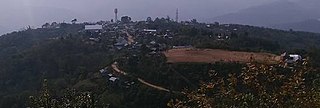
Shirui, initially called Shiroy/Shiroi, is a village located north of Ukhrul in Ukhrul district, Manipur state, India. The village is 15 kilometers from Ukhrul. National Highway 150 Imphal-Kohima via Jessami passes through the village. The village is divided into two parts, Shirui ato and Shirui aze; however, both the parts are under one chief. Shirui is famous for the rich and flora found on Shirui Kashong or Shirui peak and especially for blooming of the rare Lilium mackliniae during the start of Monsoon. The village is flanked by Ukhrul in the west, Langdang in the south, Mapum in the east, Sihai in the North east and Lunghar in the north. Locally inhabitants speak Shirui dialect which belongs to the Tibeto-Burman language family.
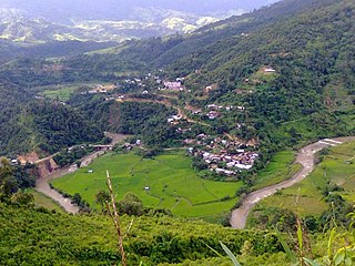
Nungshong Khullen is located south of Ukhrul in Ukhrul district, Manipur state, India. The village is about 30 kilometers from Ukhrul via the state highway that connects Ukhrul-Kamjong via Shangshak. The shorter un-metalled road from Ukhrul to Nungshong khullen is about 15 kilometers. Construction of a new road under PMGSY to connect the neighboring villages with Ukhrul is underway for which there were reports of irregularities on the part of the executing agencies. Nungshong is flanked by Hungpung in the west, Shangching in the south, Choithar and Khangkhui in the north. Locally, the residents speak Nungshong dialect which belongs to the Tibeto-Burman language family.

Shangshak is a generic reference to two villages viz. Shangshak Khullen and Shangshak Khunou located south of Ukhrul in Ukhrul district, Manipur state, India. The village is about 15 kilometers from Ukhrul via National Highway 150 and the state highway that connects Ukhrul-Kamjong via Shangshak. Shangshak is flanked by Hungpung in the north, Koso in the south, Ramva in the west and Gamnom and Yengtem in the east. The Battle of Shangshak fought for two weeks from 21 to 26 March 1944 is considered one of the bloodiest battles of the Second World War. Locally, the residents speak Shangshak dialect which belongs to the Tibeto-Burman language family.
Tashar, also known as Tushar or Tushen, is a generic reference to two villages viz. Tashar and Tashar Chanhong located south-west of Ukhrul in Ukhrul district, Manipur state, India. The village is about 18 kilometers from Ukhrul via National Highway that connects Imphal and Kohima via Ukhrul and Jessami. Tashar is flanked by Pharung in the north, Ramva in the south, Shangshak in the east and Sirarakhong in the West. The village is divided into two major parts, Tashar main and Tashar Chanhong. Locally, the inhabitants speak Tashar tui which belongs to the Tibeto-Burman language family.
Hatha is a small Village located south-west of Ukhrul in Ukhrul district, Manipur state, India. The village is about 20 kilometers from Ukhrul via National Highway 150 that connects Imphal and Kohima via Ukhrul and Jessami. Hatha is flanked by Hungpung in the north, Ramva in the south, Shangshak in the east and Tashar in the West. Locally, the inhabitants speak Hatha tui which belongs to the Tibeto-Burman language family.
Ramva also misnomerly called as Lambui is a village located south of Ukhrul in Ukhrul district, Manipur state, India. The village is about 25 kilometers from Ukhrul via National Highway 150 that connects Imphal and Kohima via Ukhrul and Jessami. Ramva is flanked by Hatha in the north, Shangshak in the east, Lungpha in the south and Tungou in the West. Locally, the inhabitants speak Ramva dialect which belongs to the Tibeto-Burman language family.
Lungpha is a village located south of Ukhrul in Ukhrul district, Manipur state, India. The village is about 15 kilometers from Ukhrul via National Highway 150 that connects Imphal and Kohima via Ukhrul and Jessami. Lungpha is flanked by Ramva in the north, Tungou in the west, Litan in the south and Shangshak in the east. Locally, the inhabitants speak Lungpha tui which belongs to the Tibeto-Burman language family.
Shingkap is a village located south of Ukhrul in Ukhrul district, Manipur state, India. The village is about 35 kilometers from Ukhrul via National Highway 150 that connects Imphal and Kohima via Ukhrul and Jessami. Shingkap is flanked by Lungpha in the north, Riha in the west, Tangkhul Hundung in the south and Alang in the east. Locally, the inhabitants speak Shingkap tui which belongs to the Tibeto-Burman language family.
Tungou also misnomerly referred to as Ringui is a village located south of Ukhrul in Ukhrul district, Manipur state, India. The village is about 35 kilometers from Ukhrul via National Highway 150 that connects Imphal and Kohima via Ukhrul and Jessami. Tungou is flanked by Ramva in the east, Tashar in the north, Sinakeithei in the west and Lungpha in the south. Locally, the inhabitants speak Tungou tui which belongs to the Tibeto-Burman language family.
Tangkhul Hundung is a village south of Ukhrul in Ukhrul district, Manipur, India. The village is about 65 kilometres (40 mi) from Ukhrul and about 45 kilometres (28 mi) from Imphal and is partially connected by National Highway 150 that connects Imphal and Kohima via Ukhrul and Jessami. Tangkhul Hundung is divided into two major parts, Tangkhul Hundung Khullen and Tangkhul Hundung Khunou. The village is flanked by Thoyee in the west, Shingkap in the north, Itham in the south and Alang in the east. Locally, the inhabitants speak Tangkhul Hundung tui, which belongs to the Tibeto-Burman language family.
Maku is a village located south east of Ukhrul in Ukhrul district, Manipur state, India. The village is about 32 kilometers from Ukhrul and is partially connected by National Highway 150 that connects Imphal and Kohima via Ukhrul and Jessami and Kamjong-Imphal state highway. The village is flanked by Shingcha in the north, Langli in the south, Chatric in the east and Yengtem in the west. Maku is a major and strategic junction for the neighboring remote village as the state highway and Inter Village Roads (IVR) converges in the vicinity of the village. Locally, the inhabitants speak Maku tui which belongs to the Tibeto-Burman language family.
Shingcha is a village located southeast of Ukhrul in Ukhrul district, Manipur state, India. The village is about 45 kilometers from Ukhrul and is partially connected by Ukhrul-Kamjong State highway. The village is flanked by Pushing in the north, Maku in the south, the Langkhe in the east and Shangshak in the west.
Pharung also called as Shimtang is a village located west of Ukhrul in Ukhrul district, Manipur state, India. The village falls under Ukhrul sub division. Pharung borders with Hunphun (Ukhrul) village and Hungpung. The village is connected by the old National highway road route. Pharung is flanked by Ukhrul in the east, Seikhor in the west, Tashar in the south and Ngainga in the north. Locally the inhabitants speak Pharung tou which belongs to the Tibeto-Burman language family.
Seikhor is a village located west of Ukhrul in Ukhrul district, Manipur state, India. The village falls under Ukhrul sub division. Seikhor is partially connected by the old Imphal-Ukhrul road and is about 18 kilometers from Ukhrul. Seikhor is flanked by Pharung in the east, Teinem in the west, Tashar in the south and Ngainga in the north. Locally, the inhabitants speak Seikhor dialect that belongs to the Tibeto-Burman language family.
Lamlang also popularly referred as Lamlang Gate is a village located west of Ukhrul in Ukhrul district, Manipur state, India. The village falls under Ukhrul sub division. The old Imphal-Ukhrul road passes through the village and is about 19 kilometers from Ukhrul. Lamlang is flanked by Seikhor in the north, Pharung in the east, Tashar in the south and Sirarakhong in the west. Locally, the inhabitants speak Lamlang dialect that belongs to the Tibeto-Burman language family.
Kangpat is a generic reference to two villages, Kangpat Khullen and Kangpat Khunou located south of Ukhrul in Ukhrul district, Manipur state, India. The village falls under Kamjong sub division. The two villages are connected by Ukhrul-Kamjong state highway. Kangpat is flanked by Sorbung and Punge in the west, Choro in the south, Skipe in the east and Nambisha in the north. Locally, the inhabitants speak Kangpat dialect that belongs to the Tibeto-Burman language family. Some researchers are of the view that the dialect spoken by the inhabitants has some affinity to that of the Koireng tribe.

