Peh pronounced "Pe-h" is a village in Ukhrul District, Manipur, India. The village was earlier called 'Paoyi', which is a misconstrued derivative of the original name 'Pehyi' given by outsiders. Peh is approximately 35 kilometers north of Ukhrul district headquarter. The village is partially connected by National Highway 150, Imphal–Kohima via Ukhrul–Jessami Highway. The village comprises two settlement areas: Proper Peh and Peh Ngahurum. The total population of the village is around 3800. The village panchayat (Sangvui) consists of the representative from different clans headed by an elected chairman is the Apex body of the village. All administrative, political and judicial decisions are taken by them. The judiciary functions are partly performed in the name of King (raja); also known as the khulakpa.
Sihai is a general reference to a group of villages in the north of Ukhrul District headquarters in Manipur. Sihai Khullen, the nearest from Ukhrul is about 37 kilometers from Ukhrul, connected partially by National Highway 150.
Longpi is a general reference to two villages in the Ukhrul District of the Indian state of Manipur. Longpi is about 37 kilometres (23 mi) north of Ukhrul, connected by National Highway 202. The two villages together have a population of over 8,000.
Somdal also called as Shongran is a village located west of Ukhrul in Ukhrul district, Manipur state in India. As per 2011 census, the village has a total of 468 families of 2375 persons of which 1209 are male while 1166 are female Of the total population, 13.14% are in the age group of 0–6 years. The average sex ratio of the village is 964 female per 1000 male. The literacy rate of the village is 92.39%.

Phalee also called as Phadang is a village located west of Ukhrul in Ukhrul district, Manipur state in India. It lies in the Indo-Burma Biodiversity Hot-Spot Region of the world wherein the flora and fauna diversity are very rich.
Sirarakhong also called as Kampha is a village located west of Ukhrul in Ukhrul district, Manipur state, India. As per 2011 census, the village has a total of 202 households with 1243 persons of which 620 are male while 623 are female. Of the total population, 10.86% are in the age group of 0–6 years. The average sex ratio of the village is 1015 female per 1000 male which is higher than the state's average of 930. The literacy rate of the village is 95.22%.
Ngainga also called Ngaimu is a village located west of Ukhrul in Ukhrul district, Manipur state, India. The village is approximately 17 kilometers from Ukhrul. As per 2011 census, the village has a total of 267 households with 2881 persons of which 964 are male while 917 are female. Of the total population, 323 are in the age group of 0–6 years. The average sex ratio of the village is 1015 female per 1000 male which is higher than the state's average of 930. The literacy rate of the village is 92.22%. Neighbouring villages of Ngainga are Seikhor, Tolloi, Phalee Somdal and Tuinem. Ngainga is the birthplace of Luingamla who was shot dead on 24 January 1986 by Indian army personnel for resisting their attempt to rape her.
Phungcham is a village located north of Ukhrul in Ukhrul district, Manipur state, India. The village is approximately 28 kilometers from Ukhrul and is connected by inter village road constructed under PMGSY. Phungcham is flanked by Longpi and Lunghar in the east, Peh in the north, Ukhrul and Halang in the south and Talui in the west.
Chingjaroi originally known Asinei /Asewnei or Swemi alternatively called Zingchui/Zingjui by the Tangkhul, Shomai by the Poumai and khotsami by the Chakhesangs is a large village located in northern Ukhrul district, Manipur state, India and bordered mainly by villages like Jessami, Tasom, Chingai, Marem, Peh, Phaibung and Laii (Gaziphema)originally. Later villages like Razai, Namrei and Kharasom came to settle in the land of chingjaroi and became its neighboring villages. The village consists of three sister villages, namely, Chingjaroi Khullen, Chingjaroi Khunou and Chingjaroi Christian Village. Chingjaroi Khullen the nearest from the National Highway 150 is approximately 84 kilometers from Ukhrul district headquarters.
Poi is a village located north of Ukhrul in Ukhrul district, Manipur state, India. The village is partially connected by National Highway 150, Imphal-Kohima road via Jessami. Poi is 68 kilometers away from Ukhrul via Awangkasom and about 3 kilometers and 5 kilometers away from Indo-Myanmar border pillar number 126 and 130 respectively. Poi is flanked by Challou in the North, Chingai in the north west, Ngahui, Kuirei and Marem in the west, Huishu and Khamasom in the south. MK Preshow Shimray, the Ex- MLA from Chingai Assembly Constituency and also the Deputy Speaker of the present Manipur Legislative Assembly hails from this village.
Kalhang is a village located north of Ukhrul in Ukhrul district, Manipur state, India. The village is approximately 39 kilometers from Ukhrul. National Highway 150 Imphal-Kohima via Jessami passes through the village. Kalhang is one of the villages that used to make indigenous salt from natural salt springs and supply to other Tangkhul villages before the introduction of common salt. The village is flanked by Phungcham and Peh in the west, Khamasom in the east, Longpi in the south and Kuirei in the North. Locally inhabitants speak Kansang dialect which belongs to the Tibeto-Burman language family.
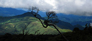
Shirui, initially called Shiroy/Shiroi, is a village located north of Ukhrul in Ukhrul district, Manipur state, India. The village is 15 kilometers from Ukhrul. National Highway 150 Imphal-Kohima via Jessami passes through the village. The village is divided into two parts, Shirui ato and Shirui aze; however, both the parts are under one chief. Shirui is famous for the rich and flora found on Shirui Kashong or Shirui peak and especially for blooming of the rare Lilium mackliniae during the start of Monsoon. The village is flanked by Ukhrul in the west, Langdang in the south, Mapum in the east, Sihai in the North east and Lunghar in the north. Locally inhabitants speak Shirui dialect which belongs to the Tibeto-Burman language family.
Langdang is a village located north of Ukhrul in Ukhrul district, Manipur state, India. The village is 13 kilometers from Ukhrul. National Highway 150 Imphal-Kohima via Jessami passes through the village. The village is divided into two major parts, Langdang Khullen and Langdang Phungthar; however, both the parts are under one chief. The village is famous for largescale plum cultivation. The village is flanked by Mapum in the east, Shirui in the north, Ukhrul in the west and Choithar in the south.
Tangkhul Hundung is a village south of Ukhrul in Ukhrul district, Manipur, India. The village is about 65 kilometres (40 mi) from Ukhrul and about 45 kilometres (28 mi) from Imphal and is partially connected by National Highway 150 that connects Imphal and Kohima via Ukhrul and Jessami. Tangkhul Hundung is divided into two major parts, Tangkhul Hundung Khullen and Tangkhul Hundung Khunou. The village is flanked by Thoyee in the west, Shingkap in the north, Itham in the south and Alang in the east. Locally, the inhabitants speak Tangkhul Hundung tui, which belongs to the Tibeto-Burman language family.
Phungyar is a small town located south of Kamjong in Kamjong district, Manipur state, India. It is also the name of a sub division of the district. The town is about 50 kilometers from Ukhrul and is partially connected by National Highway 150 that connects Imphal and Kohima via Ukhrul and Jessami. The town is flanked by Khambi in the south, Loushing in the north and alang in the west. Locally, the inhabitants speak common tangkhul language and native village dialect which belongs to the Tibeto-Burman language family.
Yengtem is a village located south of Ukhrul in Ukhrul district, Manipur state, India. The village is about 40 kilometers from Ukhrul and is partially connected by National Highway 150 that connects Imphal and Kohima via Ukhrul and Jessami and Kamjong-Imphal state highway. The village is flanked by Gamnom in the north, Apong village in the south, Maku in the east and Shangshak in the west. Yengtem is a major and strategic junction for the neighboring remote village as the state highway and Inter Village Roads (IVR) converges in the vicinity of the village. Locally, the inhabitants speak Yengtem tui which belongs to the Tibeto-Burman language family.
Ningthi is a village located west of Kamjong in Kamjong district, Manipur state, India. The village is about 20 kilometers from Kamjong and is partially connected by Ukhrul-Kamjong State highway and inter village road constructed in 2015. Ningthi is flanked by Kamjong in the east, Phungyar in the west, Tusom in the south and Hangkau in the north. Ningthi river is the main tributary of Chindwin river of Myanmar.
Hungpung also called as Hundung is a village located south in Ukhrul district, Manipur state, India. The village falls under Ukhrul sub division. HAO (Animism) religion was strictly practiced in the kingdom of "KHAYAIWUNG" i,e Kingdom of Hungpung Haokok.
Khamlang village is situated on the southern part of Ukhrul District, Manipur, India. It is inhabited by Khameon a Tangkhul Naga tribe. It is situated 2 km away from headquarter of Sub-Division, Kasom Khullen, 137 km away from district headquarter Ukhrul and 59 km from state capital Imphal, Manipur.
Itham originally and locally called Nungha is a beautiful, under-populated Tangkhul village in Kamjong District, Manipur state, India.It was previously under Ukhrul District. The village falls under Kasom sub division. The village can be connected by National Highway 102A that connects Shangshak-Yairipok via Hongbei area of Chongdan village. Also it connects Imphal via Nongdam village. Itham share boundaries with Tangkhul Hundungvillage in the north, Bohoram village in the east and south and Nongdam village in the west. It is situated 16km away from kasom khullen sub-district headquater and 149 km away from Ukhrul headquater with the route passing through Lungphu village, Shingta village, Marou village, Shingkap village and Tangkhul Hundung. The village is well known for its fresh organic vegetable shops by the roadside with no shopkeeper.

