Kaien Island

Last updated

Kaien Island dusted in frost Kaien Island dusted in frost.jpg
Kaien Island dusted in frost
Kaien Island showing Prince Rupert Prince Rupert Harbour.png
Kaien Island showing Prince Rupert

Kaien Island is a Canadian island on the coast of British Columbia, just north of the mouth of the Skeena River and to the south of the Alaska Panhandle. [1] The island has an area of about 45 square kilometres (11,000 acres), is roughly oval, and about 11 kilometres (6.8 miles) long along its long axis. [2] The island consists of a central mountain ridge, surrounded by coastal lowlands. The dominant central peak is Mount Hays, reaching 708 metres (2,323 ft), [3] with a secondary peak, Mount Olfield, reaching 555 metres (1,821 ft) [4] to the northeast.

Contents

The island is contained within the North Coast Regional District and is part of the North Coast region. Tidal waters surrounding the island have a wide range which results in extensive exposure of mud flats and rock shoals that are prime habitat for invertebrates and intertidal fish. [5]

Kaien Island is central to the traditional territories of the Tsimshian First Nations, and has been permanently settled for more than 5,000 years. [5] The city of Prince Rupert is on the island. Casey Point is on the western extremity of the island, [6] facing Digby Island, and was the site of one of the coastal defence installations to protect the BC Coast during World War II. Another such installation was at Seal Cove on the island's northern tip. [7]

Geology

Located within the Hecate Depression of the Coastal Trough, the island is a situated between the Coast Mountains and the continental shelf, and has been influenced by tectonic subsidence and glacial history. It has a central mountainous spine with peaks like Mount Hays 708 metres (2,323 ft), and surrounding lowlands, reflecting both deep-seated structural patterns and surface erosion.

The dominant bedrock of Kaien Island is amphibolite, dating to the early Mesozoic or Paleozoic. The bedrock strata on the island dip eastward at about 35°, suggesting deformation likely tied to regional tectonic forces. [8] Within this bedrock, are inclusions of feldspathic schist, quartzite, and hornblende schist. [8] Surficial deposits include colluvial material, organic and alluvial sediments, with some glacial till from past glaciations. [9]

Ecology

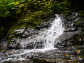
Kaien Island supports a Pacific temperate rainforest and marine–estuarine ecology shaped by high rainfall, cool temperatures, and strong ocean influence . [10] The Island's ecology is notable for its tight coupling between land, freshwater, and marine systems, making the island ecologically resilient but also sensitive to disturbance. [11] The island has long supported Tsimshian harvesting, stewardship, and settlement, and today its ecosystems remain central to regional biodiversity and cultural landscapes.

Terrestrial

Kaien Island lies within the Coastal Western Hemlock biogeoclimatic zone. Forests are typically dense, multi-layered, and moisture-rich, dominated by western hemlock, sitka spruce, western red cedar, and amabilis fir. The forest floor supports abundant mosses, lichens, ferns, and shade-tolerant shrubs such as salal, devil's club, and salmonberry. Poorly drained areas develop into muskeg and peatlands, characterized by shallow soils, sphagnum moss, sedges, Labrador tea, and stunted shore pine. [12]

Freshwater and Estuarine

Island streams and wetlands drain into surrounding bays and inlets, which support a variety of pacific salmon species, including pink, chum, and coho. [13] Local Estuaries include mudflats and salt marshes, eelgrass beds, brackish channels and tidal creeks which offer nursery habitat for juvenile fish, feeding grounds for shorebirds, and refuge for invertebrates. [14]

Marine and Intertidal

The rocky and muddy shorelines host north pacific intertidal communities including, barnacles, mussels, rockweed, kelp, sea stars, crabs, chitons, and snails. [15] The surrounding marine environment provides nutrient-rich waters driven by tidal mixing and freshwater input sustaining kelp forests and macroalgae, dungeness crab, pacific herring and forage fish, seals, sea lions, porpoises, and whales.

See also

References

  1. "Kaien Island". BC Geographical Names .
  2. "Bulk Liquids Terminal, South Kaien Island, Prince Rupert, BC, Volume II Environmental Report" (PDF). Ocean Ecology.
  3. "Mount Hays". BC Geographical Names .
  4. "Mount Olfield". BC Geographical Names .
  5. 1 2 "Coast Tsimshian pre-contact Economics and Trade: An Archaeological and Ethno-historic reconstruction" (PDF). University of British Columbia .
  6. "Casey Point". BC Geographical Names .
  7. "Seal Cove". BC Geographical Names .
  8. 1 2 Crawford, M. L.; Crawford, W. A.; Gehrels, G. E. Terrane assembly and structural relationships in the eastern Prince Rupert quadrangle, British Columbia (PDF). Retrieved 28 December 2025.
  9. Clague, John J. (1984). Quaternary Geology and Geomorphology, Smithers‑Terrace‑Prince Rupert Area, British Columbia. Geological Survey of Canada Memoir. Vol. 413. Ottawa, Canada: Geological Survey of Canada. ISBN   0660116278.
  10. Bidlack, A.L.; et al. (Bisbing, S.M.; Buma, B.) (2021). "Climate‑Mediated Changes to Linked Terrestrial and Marine Ecosystems across the Northeast Pacific Coastal Temperate Rainforest Margin". BioScience. 71 (6): 581–595. doi:10.1093/biosci/biaa171.
  11. Bidlack, A.L.; et al. (Edwards, K.; Oliver, S.) (2020). Advancing an Integrated Understanding of Land–Ocean Connections in Coastal Temperate Rainforest Regions (Report). NOAA Coastal Studies.
  12. "Terrestrial Ecosystem Mapping — CWHvm1 Bog and Wetland Site Series" (PDF). BC Government Terrestrial Ecosystem Mapping. Retrieved 2025-12-27. Bog woodland ecosystems in the Coastal Western Hemlock (CWHvm1) variant occur on poorly drained depressional sites with deep organic soils. Characteristic vegetation includes mosses such as common green sphagnum and shrubs including Labrador tea (Ledum), salal, and shore pine in open bog woodland.
  13. Chilibeck, Branden; Bateman, Andrew; Connors, Brian M. (2014). "Juvenile Salmon Usage of the Skeena River Estuary". PLOS ONE. 9 (2): e89988. doi: 10.1371/journal.pone.0118988 . PMC   4352006 . PMID   25749488. We captured six species of juvenile anadromous salmonids throughout the Skeena River estuary in both years,
  14. Ocean Ecology (May 21, 2014). Skeena River Estuary Juvenile Salmon Habitat (PDF) (Technical report). Prince Rupert, British Columbia: Ocean Ecology. Retrieved 28 December 2025.
  15. Rubidge, Emily; Jeffery, Sharon; Gregr, Edward J.; Gale, Katie S. P.; Frid, Alejandro (2020). Assessment of nearshore features in the Northern Shelf Bioregion against criteria for determining Ecologically and Biologically Significant Areas (EBSAs) (PDF) (Report). DFO Can. Sci. Advis. Sec. Sci. Resp. Ottawa, Ontario: Fisheries and Oceans Canada, Canadian Science Advisory Secretariat.

Images

54°16′58″N130°18′12″W / 54.28274°N 130.30341°W / 54.28274; -130.30341