Kansai Science City

Last updated • 3 min readFrom Wikipedia, The Free Encyclopedia
Keihanna Science City
関西文化学術研究都市
けいはんな学研都市
Kansai Science City
Keihanna Plaza.jpg
Keihanna Plaza in Seika
Kansai Science City
Coordinates: 34°44′42″N135°45′54″E / 34.745°N 135.765°E / 34.745; 135.765
Country Japan
Region Kansai
Prefectures
OpenedOctober 1994
Founded byAzuma Okuda
Area
  Total
154.12 km2 (59.51 sq mi)
Population
 (April 1, 2021) [2]
  Total
253,729
  Density1,600/km2 (4,300/sq mi)
Time zone UTC+9 (JST)
Website www.kri.or.jp/en/
Doshisha University in Kyotanabe The Learned Memorial Library at Doshisha University, Kyotanabe, Japan.JPG
Doshisha University in Kyōtanabe

Kansai Science City (関西文化学術研究都市, Kansai Bunka-gakujutsu-kenkyū-toshi) is an unincorporated city located in the Keihanna Hills (京阪奈丘陵, Keihanna kyūryō), a border region between Kyoto, Osaka, and Nara Prefectures in Kansai region, Japan. The name is commonly shortened [a] to Keihanna Science City (けいはんな学研都市, Keihanna Gakken-toshi) or Gakken-toshi (学研都市). The name Keihanna is constructed by extracting a representative kanji from Kyoto, Osaka, and Nara. It is about 25 kilometers (16 mi) south of the city of Kyoto and 30 kilometers (19 mi) east of the city of Osaka. The city was constructed to help the advancement of creative arts, sciences, and research, as well as to spur the creation of new industries and cultures.

Contents

Location

Historical population
YearPop.±%
1986 128,278    
1991 171,805+33.9%
1996 194,514+13.2%
2001 212,826+9.4%
2006 228,425+7.3%
2011 241,020+5.5%
2016 248,435+3.1%
2021 253,729+2.1%
Source: [2]

Kansai Science City is located in portions of the following eight cities (, shi) and towns (, chō), in three prefectures:

Out of these, Seika in Kyoto Prefecture is completely inside the Kansai Science City.

The overall area of the Kansai Science City is 154 square kilometers (59 sq mi), with an estimated population of 250,000. There are 12 "Cultural and Academic Research Zones" within the Kansai Science City, encompassing 33 square kilometers (13 sq mi), with an estimated population of 100,000. Seika & Nishikizu is the central district of this city. Fugenji and Kita-Tawara are science districts in land use adjustment.

Areas, populations, and zones as of 1 April 2021 [1] [2]
JurisdictionOsaka PrefectureKyoto PrefectureNara PrefectureTotal
HirakataShijōnawateKatanoKyōtanabeSeikaKizugawaNaraIkoma
Area15.10 km214.70 km215.50 km224.42 km225.68 km223.62 km214.60 km220.50 km2154.12 km2
Population33,24411,38214,51522,12658,07937,02452,40324,956253,729
Cultural and Academic Research ZoneHimuro & Tsuda (0.74 km2)Seika & Nishikizu (5.06 km2)Takayama (3.33 km2)
  • (33.29 km2)
  • Population : 100,261
Kiyotaki & Muroike (3.40 km2)Heijo & Soraku (6.26 km2)
Tanabe (1.00 km2)Kizu (7.37 km2)
Minamitanabe & Komada (3.44 km2) Heijo Palace Site (1.42 km2)
Tawara (1.27 km2)FugenjiKita-Tawara
Aerial photographs [3]

Main research institutes and universities

Universities

Research institutes

Other

Transportation

In 2016, a government committee planning the final Kyoto-Osaka segment of the Hokuriku Shinkansen proposed routing the new high-speed line through Kyōtanabe. [9]

About 100 minutes by bus from Kansai International Airport.

Notes

    1. The Japanese form of the official name, which literally translates to Kansai Culture and Academic Research City, is substantially longer than the official English name.

    Related Research Articles

    <span class="mw-page-title-main">Nara Prefecture</span> Prefecture of Japan

    Nara Prefecture is a prefecture of Japan located in the Kansai region of Honshu. As of 2020, Nara Prefecture has a population of 1,321,805 and has a geographic area of 3,691 square kilometres (1,425 sq mi). Nara Prefecture borders Kyoto Prefecture to the north, Osaka Prefecture to the northwest, Wakayama Prefecture to the southwest, and Mie Prefecture to the east.

    <span class="mw-page-title-main">Jōyō, Kyoto</span> City in Kansai, Japan

    Jōyō is a city located in Kyoto Prefecture, Kansai, Japan. As of 1 September 2023, the city has an estimated population of 72,869 in 30720 households and a population density of 2200 persons per km². The total area of the city is 32.71 square kilometres (12.63 sq mi).

    <span class="mw-page-title-main">Kyōtanabe, Kyoto</span> City in Kansai, Japan

    Kyōtanabe is a city located in the southern part of Kyoto Prefecture, Japan. As of 1 September 2023, the city has an estimated population of 71,757 in 31555 households and a population density of 1700 persons per km2. The total area of the city is 42.92 square kilometres (16.57 sq mi).

    <span class="mw-page-title-main">Takatsuki</span> Core city in Kansai, Japan

    Takatsuki is a city in Osaka Prefecture, Japan. As of 31 March 2023, the city had an estimated population of 348,020 in 164,494 households and a population density of 3.300 persons per km2. The total area of the city is 105.29 square kilometres (40.65 sq mi).

    <span class="mw-page-title-main">Kashiwara</span> City in Kansai, Japan

    Kashiwara is a city located in Osaka Prefecture, Japan. As of 31 January 2022, the city had an estimated population of 67,698 in 32007 households and a population density of 2,700 inhabitants per square kilometre (7,000/sq mi). The total area of the city is 25.33 square kilometres (9.78 sq mi).

    <span class="mw-page-title-main">Higashiōsaka</span> Core city in Kansai, Japan

    Higashiōsaka is a city located in Osaka Prefecture, Japan. As of 1 July 2023, the city had an estimated population of 486,464 in 233,124 households and a population density of 7,874 persons per km2. The total area of the city is 61.78 square kilometres (23.85 sq mi). The city is known as one of the industrial cities of Japan and "the rugby football town".

    <span class="mw-page-title-main">Ikoma, Nara</span> City in Kansai, Japan

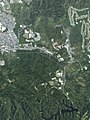
    Ikoma is a city in the northwestern end of Nara Prefecture in the Kansai region of Japan. It was founded on November 1, 1971. As of September 1, 2023, the city has an estimated population of 117,259, with 51,478 households. It has a population density of 2,300 persons per km², and it has the third largest population in the prefecture. The total area is 53.18 km². The city is known as one of the most affluent suburbs of the Greater Osaka Metropolitan Area (Keihanshin), with a high rate of college graduates, professionals, and company directors amongst its residents. As a result, the city has developed as a satellite city of Osaka, with some 54% of its residents commuting across prefectural borders to Osaka. Kansai Science City is partially located in Ikoma, which is also home to the Nara Institute of Science and Technology. The city is also famous for chasen.

    <span class="mw-page-title-main">Kintetsu Railway</span> Japanese passenger railway company

    Kintetsu Railway Co., Ltd., referred to as Kintetsu (近鉄) and officially Kinki-Nippon Railway, is a Japanese passenger railway company, managing infrastructure and operating passenger train service. Its railway system is the largest in Japan, excluding Japan Railways Group. The railway network connects Osaka, Nara, Kyoto, Nagoya, Tsu, Ise, and Yoshino. Kintetsu Railway Co., Ltd. is a wholly owned subsidiary of Kintetsu Group Holdings Co., Ltd.

    <span class="mw-page-title-main">Keihanshin</span> Metropolitan region in the Kansai region of Japan

    Keihanshin is a metropolitan region in the Kansai region of Japan encompassing the metropolitan areas of the cities of Kyoto in Kyoto Prefecture, Osaka in Osaka Prefecture and Kobe in Hyōgo Prefecture. The entire region has a population of 19,302,746 over an area of 13,228 km2 (5,107 sq mi). It is the second-most-populated urban region in Japan, containing approximately 15% of Japan's population.

    <span class="mw-page-title-main">Seika, Kyoto</span> Town in Kansai, Japan

    Seika is a town located in Sōraku District, Kyoto Prefecture, Japan. As of 1 September 2023 the town has an estimated population of 36,542 in 15468 households and a population density of 1400 persons per km2. The total area of the town is 25.68 square kilometres (9.92 sq mi).

    <span class="mw-page-title-main">Katamachi Line</span> Railway line in Japan

    The Katamachi Line, officially nicknamed the Gakkentoshi Line, is a commuter rail line and service in the Osaka-Kobe-Kyoto Metropolitan Area of Japan, owned and operated by West Japan Railway Company. The line connects Kizu Station in Kyoto Prefecture and Kyōbashi Station in Osaka.

    <span class="mw-page-title-main">Ikoma Station</span> Railway and funicular station in Ikoma, Nara Prefecture, Japan

    Ikoma Station (生駒駅) is a railway station in Ikoma, Nara Prefecture, Japan.

    <span class="mw-page-title-main">Nara (city)</span> City in Nara prefecture, Japan

    Nara is the capital city of Nara Prefecture, Japan. As of 2022, Nara has an estimated population of 367,353 according to World Population Review, making it the largest city in Nara Prefecture and sixth-largest in the Kansai region of Honshu. Nara is a core city located in the northern part of Nara Prefecture bordering the Kyoto Prefecture.

    <span class="mw-page-title-main">Kizugawa, Kyoto</span> City in Kansai, Japan

    Kizugawa is a city located in southern Kyoto Prefecture, Japan. As of 1 September 2023, the city has an estimated population of 79,866 in 33183 households and a population density of 940 persons per km2. The total area of the city is 85.12 square kilometres (32.87 sq mi).

    <span class="mw-page-title-main">Yumehanna</span> Railway line in Osaka, Japan

    Yumehanna (ゆめはんな) is the collective nickname for the Chūō Line of the Osaka Metro and the Keihanna Line of the Kintetsu Railway in Osaka Prefecture and Nara Prefecture, Japan. The two lines operate through trains between Cosmosquare Station, the western terminus of the Chūō Line in Suminoe-ku, Osaka, and Gakken Nara-Tomigaoka Station, the eastern terminus of the Keihanna Line in Nara.

    <span class="mw-page-title-main">Gakken Kita-Ikoma Station</span> Railway station in Ikoma, Nara Prefecture, Japan

    Gakken Kita-Ikoma Station is a train station on the Kintetsu Keihanna Line in Ikoma, Nara Prefecture, Japan. It is the nearest station to Nara Institute of Science and Technology.

    <span class="mw-page-title-main">Gakken Nara-Tomigaoka Station</span> Railway station in Nara, Nara Prefecture, Japan

    Gakken Nara-Tomigaoka Station is a passenger railway station located in the city of Nara, Nara Prefecture, Japan. It is operated by the private transportation company, Kintetsu Railway.

    Gakken can refer to:

    Greater Kyoto is a metropolitan area in Japan encompassing Kyoto City, the capital of Kyoto Prefecture, as well as its surrounding areas including Ōtsu, the capital of Shiga Prefecture.

    References

    1. 1 2 "Structure and Scale of Keihanna Science City" . Retrieved September 3, 2020.
    2. 1 2 3 4 "Population" (PDF) (in Japanese). Kansai Research Institute.
    3. National Land Image Information (Color Aerial Photography), Ministry of Land, Infrastructure, Transport and Tourism.
    4. リンク/大阪大学 自由電子レーザー研究施設
    5. Advanced Telecommunications Research Institute International
    6. International Institute for Advanced Studies
    7. Kansai Electronic Industry Development Center
    8. Research Institute of Innovative Technology for the Earth
    9. "北陸新幹線、「けいはんな」通る第3案 京都と大阪間、与党委". The Nikkei. 12 April 2016. Retrieved 13 April 2016.

    This article was translated from a portion of the corresponding article in the Japanese Wikipedia, retrieved on December 10, 2006.

    See also