Kanwaka, Kansas

Last updated

Kanwaka, Kansas
Map of Douglas Co, Ks, USA.png
USA Kansas location map.svg
Red pog.svg
Kanwaka
Usa edcp location map.svg
Red pog.svg
Kanwaka
Coordinates: 38°58′00″N95°24′31″W / 38.96667°N 95.40861°W / 38.96667; -95.40861 [1]
Country United States
State Kansas
County Douglas
Founded1854
Elevation
[1]
1,066 ft (325 m)
Time zone UTC-6 (CST)
  Summer (DST) UTC-5 (CDT)
Area code 785
FIPS code 20-36065 [1]
GNIS ID 484875 [1]

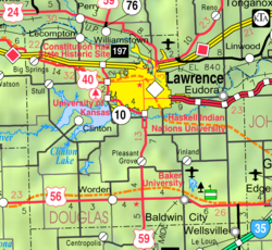
Kanwaka is an unincorporated community in Douglas County, Kansas, United States. [1] It is located 4 miles west of Lawrence. The name is a portmanteau of the Kansas and Wakarusa Rivers.

Contents

History

Kanwaka was first settled in 1854. Kanwaka had a post office from 1857 to 1870 and again from 1898 until 1900. [2]

Geography

Kanwaka is located at the intersection of U.S. Highway 40 and Stull Road.

Related Research Articles

<span class="mw-page-title-main">Douglas County, Kansas</span> County in Kansas, United States

Douglas County is located in the U.S. state of Kansas. Its county seat and most populous city is Lawrence. As of the 2020 census, the county population was 118,785, making it the fifth-most populous county in Kansas. The county was named after Stephen Douglas, a U.S. Senator from Illinois and advocate for the moderate popular sovereignty choice in the Kansas slavery debate.

<span class="mw-page-title-main">Franktown, Colorado</span> Census Designated Place in Colorado, United States

Franktown is an unincorporated town, a post office, and a census-designated place (CDP) located in and governed by Douglas County, Colorado, United States. The CDP is a part of the Denver–Aurora–Lakewood, CO Metropolitan Statistical Area. The Franktown post office has the ZIP Code 80116. At the United States Census 2020, the population of the Franktown CDP was 409.

<span class="mw-page-title-main">Vinland, Kansas</span> Unincorporated community in Kansas, United States

Vinland is an unincorporated community in Douglas County, Kansas, United States. It is located south of Lawrence and north of Baldwin City.

<span class="mw-page-title-main">Stull, Kansas</span> Unincorporated community in Kansas, United States

Stull is an unincorporated community in Douglas County, Kansas, United States. Founded in 1857, the settlement was initially known as Deer Creek until it was renamed after its only postmaster, Sylvester Stull. As of 2018, only a handful of structures remain in the area.

<span class="mw-page-title-main">Clinton Township, Douglas County, Kansas</span> Township in Kansas, United States

Clinton Township is a township in Douglas County, Kansas, USA. As of the 2000 census, its population was 531. It took its name from Clinton, Illinois.

<span class="mw-page-title-main">Kanwaka Township, Douglas County, Kansas</span> Township in Kansas, United States

Kanwaka Township is a township in Douglas County, Kansas, USA. As of the 2000 census, its population was 1,317. The name is a portmanteau of the Kansas River and Wakarusa River.

<span class="mw-page-title-main">Lecompton Township, Douglas County, Kansas</span> Township in Kansas, United States

Lecompton Township is a township in Douglas County, Kansas, USA. As of the 2000 census, its population was 1,761.

<span class="mw-page-title-main">Willow Springs Township, Douglas County, Kansas</span> Township in Kansas, United States

Willow Springs Township is a township in Douglas County, Kansas, USA. As of the 2000 census, its population was 1,409. Willow Springs Township was formed in 1856. It was named after a small watering stop along the Santa Fe Trail.

<span class="mw-page-title-main">Wakarusa, Kansas</span> Unincorporated community in Shawnee County, Kansas

Wakarusa is an unincorporated community in Shawnee County, Kansas, United States. As of the 2020 census, the population of the community and nearby areas was 242. It is located 11 miles (18 km) south of downtown Topeka. Wakarusa is also the name of an unincorporated community in adjacent Douglas County, Kansas, 6.6 mi (10.6 km) southwest of downtown Lawrence and the name of the township that includes Lawrence, Kansas.

<span class="mw-page-title-main">Clearfield, Kansas</span> Unincorporated community in Kansas, United States

Clearfield is an unincorporated community in Douglas County, Kansas, United States. It is located nine miles northeast of Baldwin City.

<span class="mw-page-title-main">Globe, Kansas</span> Unincorporated community in Kansas, United States

Globe is an unincorporated community in Douglas County, Kansas, United States. It is located along U.S. Highway 56 in Marion Township. To the west of Globe is the Simmons Point Station.

<span class="mw-page-title-main">Grover, Kansas</span> Unincorporated community in Kansas, United States

Grover is an unincorporated community in Douglas County, Kansas, United States. It is located 4 miles west of Lecompton and 6 miles east of Tecumseh.

<span class="mw-page-title-main">Hesper, Kansas</span> Unincorporated community in Douglas County, Kansas

Hesper is an unincorporated community in Douglas County, Kansas, United States. It is located two and a half miles southeast of Eudora.

<span class="mw-page-title-main">Lake View, Kansas</span> Unincorporated community in Kansas, United States

Lake View is an unincorporated community in Douglas County, Kansas, United States. It is located 1 mile north of Lawrence.

<span class="mw-page-title-main">Lone Star, Kansas</span> Unincorporated community in Kansas, United States

Lone Star is an unincorporated community in Douglas County, Kansas, United States. It is located 7 miles (11 km) southwest of Lawrence.

<span class="mw-page-title-main">Pleasant Grove, Kansas</span> Unincorporated community in Kansas, United States

Pleasant Grove is an unincorporated community in Douglas County, Kansas, United States. It is located four miles south of Lawrence.

<span class="mw-page-title-main">Worden, Kansas</span> Unincorporated community in Douglas County, Kansas

Worden is an unincorporated community in Douglas County, Kansas, United States. It is located seven miles west of Baldwin City and nine miles east of Overbrook along U.S. Highway 56.

<span class="mw-page-title-main">Norwood, Kansas</span> Ghost town in Franklin County, Kansas

Norwood is a ghost town in north Franklin County, Kansas, United States. It is located approximately 1.25 miles (2.01 km) east of U.S. Route 59 on Stafford Rd, and 2 miles (3.2 km) south of the Franklin-Douglas county line.

Media is a ghost town in Douglas County, Kansas, United States.

<span class="mw-page-title-main">Weaver, Kansas</span> Ghost town in Kansas, United States

Weaver is a ghost town in Douglas County, Kansas, United States.

References

  1. 1 2 3 4 5 "Kanwaka, Kansas", Geographic Names Information System , United States Geological Survey, United States Department of the Interior
  2. "Kansas Post Offices, 1828-1961, page 2". Kansas Historical Society. Retrieved June 8, 2014.

Further reading