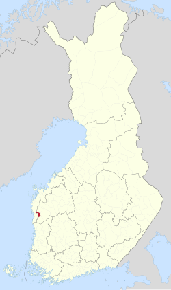
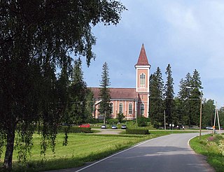
Liminka is a municipality in the Northern Ostrobothnia region in Finland. Liminka is located about 25 kilometres (16 mi) south of Oulu.

Evijärvi is a municipality of Finland. It is located in the Southern Ostrobothnia region. The municipality has a population of 2,270 and covers an area of 390.71 square kilometres (150.85 sq mi) of which 36.7 km2 (14.2 sq mi) is water. The population density is 6.41 inhabitants per square kilometre (16.6/sq mi).

Halsua is a municipality of Finland.
Isojoki is a municipality of Finland. It is part of the South Ostrobothnia region. The city of Pori is located 83 kilometres (52 mi) south of Isojoki. Neighbouring municipalities are Honkajoki, Karijoki, Kauhajoki, Kristinestad, Merikarvia and Siikainen. The population of Isojoki is 1,798. The municipality covers an area of 642.4 km2 (248.0 sq mi), of which 5.05 km2 (1.95 sq mi) is inland water. The population density is 2.8/km2 (7.3/sq mi). The municipality is unilingually Finnish.

Isokyrö is a municipality of Finland. It is located in the South Ostrobothnia region, 43 kilometres (27 mi) from Vaasa. The municipality has a population of 4,313 and covers an area of 356.91 square kilometres (137.80 sq mi) of which 2.79 km2 (1.08 sq mi) is water. The population density is 12.18 inhabitants per square kilometre (31.5/sq mi).

Kannus is a town and municipality of Finland. It is situated in the province of Western Finland and is part of the Central Ostrobothnia region. The municipality has a population of 5,260 and covers an area of 470.65 square kilometres (181.72 sq mi), of which 2.41 km2 (0.93 sq mi) is water. The population density is 11.24 inhabitants per square kilometre (29.1/sq mi). The municipality is unilingually Finnish. Neighbour municipalities are Kalajoki, Kokkola, Sievi and Toholampi.
Kauhajoki is a town and municipality of Finland. It is located in the province of Western Finland and is part of the Southern Ostrobothnia region, 59 kilometres (37 mi) southwest of the city of Seinäjoki. The population of Kauhajoki is 12,572 and the municipality covers an area of 1,298.98 km2 (501.54 sq mi) of which 16.46 km2 (6.36 sq mi) is inland water. The population density is 9.68/km2 (25.1/sq mi). The town is unilingually Finnish.

Korsnäs is a municipality in Finland, located on the west coast of the country. Korsnäs is situated in Ostrobothnia, along the Gulf of Bothnia. The population of Korsnäs is approximately 2,000, while the sub-region has a population of approximately 111,000. It is the 258th most populous municipality in Finland.

Kuortane is a municipality of Finland. It is located in the South Ostrobothnia region. The municipality has a population of 3,332 and covers an area of 484.88 square kilometres (187.21 sq mi) of which 22.72 km2 (8.77 sq mi) is water. The population density is 7.21 inhabitants per square kilometre (18.7/sq mi). The neighboring municipalities of Kuortane are Alajärvi, Alavus, Lapua and Seinäjoki. The municipality is unilingually Finnish.

Malax is a municipality in Finland, located on the west coast of the country. Malax is situated in Ostrobothnia, along the Gulf of Bothnia. The population of Malax is approximately 5,000, while the sub-region has a population of approximately 111,000. It is the 160th most populous municipality in Finland.

Merijärvi is a municipality of Finland.

Nivala is a town and municipality of Finland. It is located in the Northern Ostrobothnia region. The town has a population of 10,383 (31 October 2024) and covers an area of 536.88 square kilometres (207.29 sq mi) of which 8.92 km2 (3.44 sq mi) is water. The population density is 19.69 inhabitants per square kilometre (51.0/sq mi). The municipality is unilingually Finnish.

Pyhäntä is a municipality of Finland. It is located in the Northern Ostrobothnia region. The municipality has a population of 1,655 (31 October 2024) and covers an area of 847.48 square kilometres (327.21 sq mi) of which 36.72 km2 (14.18 sq mi) is water. The population density is 2.04 inhabitants per square kilometre (5.3/sq mi). The municipality is unilingually Finnish.

Siikajoki is a municipality of Finland. It is part of the North Ostrobothnia region. The municipality has a population of 4,792 (31 October 2024) and covers an area of 1,653.89 square kilometres (638.57 sq mi) of which 601.94 km2 (232.41 sq mi) is water. The population density is 4.54 inhabitants per square kilometre (11.8/sq mi). Neighbour municipalities are Hailuoto, Liminka, Lumijoki, Raahe and Siikalatva.

Soini is a municipality of Finland. It is located in the Southern Ostrobothnia region. The municipality has a population of 1,802 and covers an area of 574.22 square kilometres (221.71 sq mi) of which 22.17 km2 (8.56 sq mi) is water. The population density is 3.26 inhabitants per square kilometre (8.4/sq mi).
Teuva is a municipality of Finland.
Toholampi is a municipality of Finland.

Tyrnävä is a municipality in the North Ostrobothnia region of Finland with a population of 6,492 (31 October 2024). It covers an area of 494.85 square kilometres (191.06 sq mi), of which 3.07 km2 (1.19 sq mi) is water. The population density is 13.2 inhabitants per square kilometre (34/sq mi). The municipality is unilingually Finnish. The city of Oulu is located about 30 kilometres (19 mi) north of the center of Tyrnävä.
Utajärvi is a municipality of Finland. It is located in the Northern Ostrobothnia region next to the border of the Kainuu region, and is part of the former province of Oulu. It is 58 kilometres (36 mi) from Utajärvi to Oulu and 125 kilometres (78 mi) to Kajaani. The municipality has a population of 2,479 (31 October 2024) and covers an area of 1,736.73 square kilometres (670.56 sq mi) of which 65.55 km2 (25.31 sq mi) is water. The population density is 1.48 inhabitants per square kilometre (3.8/sq mi). The municipality is unilingually Finnish.
Veteli is a municipality of Finland.