
The Northwest Territories is a federal territory of Canada. At a land area of approximately 1,127,711.92 km2 (435,412.01 sq mi) and a 2021 census population of 41,070, it is the second-largest and the most populous of the three territories in Northern Canada. Its estimated population as of the second quarter of 2024 is 44,920. Yellowknife is the capital, most populous community, and only city in the territory; its population was 20,340 as of the 2021 census. It became the territorial capital in 1967, following recommendations by the Carrothers Commission.

Tyne and Wear is a ceremonial county in North East England. It borders Northumberland to the north and County Durham to the south, and the largest settlement is the city of Newcastle upon Tyne.
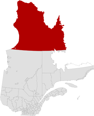
Nunavik is an area in Canada which comprises the northern third of the province of Quebec, part of the Nord-du-Québec region and nearly coterminous with Kativik. Covering a land area of 443,684.71 km2 (171,307.62 sq mi) north of the 55th parallel, it is the homeland of the Inuit of Quebec and part of the wider Inuit Nunangat. Almost all of the 14,045 inhabitants of the region, of whom 90% are Inuit, live in fourteen northern villages on the coast of Nunavik and in the Cree reserved land (TC) of Whapmagoostui, near the northern village of Kuujjuarapik.

Meghalaya is a state in northeast India. Meghalaya was formed on 21 January 1972 by carving out two districts from the state of Assam: (a) the United Khasi Hills and Jaintia Hills and (b) the Garo Hills. The estimated population of Meghalaya in 2014 was 3,211,474. Meghalaya covers an area of approximately 22,429 square kilometres, with a length-to-breadth ratio of about 3:1.

The administrative divisions of New York are the various units of government that provide local services in the American state of New York. The state is divided into boroughs, counties, cities, towns, and villages. They are municipal corporations, chartered (created) by the New York State Legislature, as under the New York State Constitution the only body that can create governmental units is the state. All of them have their own governments, sometimes with no paid employees, that provide local services. Centers of population that are not incorporated and have no government or local services are designated hamlets. Whether a municipality is defined as a borough, city, town, or village is determined not by population or land area, but rather on the form of government selected by the residents and approved by the New York State Legislature. Each type of local government is granted specific home rule powers by the New York State Constitution. There are still occasional changes as a village becomes a city, or a village dissolves, each of which requires legislative action. New York also has various corporate entities that provide local services and have their own administrative structures (governments), such as school and fire districts. These are not found in all counties.

Gagetown is a former village in Queens County, New Brunswick, Canada. It held village status prior to 2023 and is now part of the village of Arcadia. It is on the west bank of the Saint John River and is the county's shire town.

Kohima is the capital of the North East Indian state of Nagaland. With a resident population of almost 100,000, it is the second largest city in the state. Kohima constitutes both a district and a municipality. The municipality covers 20 km2 (7.7 sq mi). The city lies on the foothills of Japfü section of the Barail Range located south of the District and has an average elevation of 1,261 m (4,137 ft).

Jaunpur is a city and a municipal board in Jaunpur district in the Indian state of Uttar Pradesh. It is located 228 km southeast of state capital Lucknow. Demographically, Jaunpur resembles the rest of the Purvanchal area in which it is located.

Bhadohi district is a district of Uttar Pradesh state in northern India. It is also referred to as Sant Ravidas Nagar. It is the smallest district by area in the state of Uttar Pradesh which was created on June 30, 1994 by dividing western part of the district Varanasi. It is surrounded by Varanasi district on east, Allahabad on west, Jaunpur north and Mirzapur district in south. The state capital Lucknow is distanced at 234 KM from Bhadohi. Its district headquarters is situated in the city of Gyanpur. The district is popularly known for carpet weaving as it is one of largest centres of Carpet Industries in India and therefore it also known as the 'Carpet City of India'. Carpets of Bhadohi have 'Geographical Indication' tag attached to it. Bhadohi has huge geographical significance and position attached to it due to its location between two culturally important and rich heritage cities of Prayagraj and Varanasi.
Ashok Kumar is an Indian politician from Samastipur ( Bihar) and of the 'वारिसनगर' Bihar Legislative Assembly. He was elected from Warisnagar constituency in the 2015 Bihar Legislative Assembly election as a candidate from Janata Dal (United) of the Mahagathbandhan (Bihar). He is from Katghara village. He is commonly known as Munna Mandal by the villagers.
Harugeri (ಹಾರುಗೇರಿ) is a town in Raybag tehsilin Belguam District of the Indian state of Karnataka.

Bahrabise is an urban municipality located in Sindhupalchok District of Bagmati Province of Nepal.

Sceptre is a special service area in the Canadian province of Saskatchewan within the Rural Municipality of Clinworth No. 230 and Census Division No. 8. It held village status between 1913 and 2022.
Premraja is a small village with a population of around 500, located in the Ballia district of Uttar Pradesh state, India. Its political location is such that it lies very near to the borders of four districts of UP named Mau, Azamgarh, Ballia and Deoria. It is almost 1.5 km east to the native village, Ibrahimpatti, of former Indian Prime Minister Late Shri Chandra Shekhar (Singh).

The Rural Municipality of Mount Hope No. 279 is a rural municipality (RM) in the Canadian province of Saskatchewan within Census Division No. 10 and SARM Division No. 5.

Pema Khandu is an Indian politician and the Chief Minister of Arunachal Pradesh. He is the son of former Chief Minister of Arunachal Pradesh Dorjee Khandu. Since assuming the office of the Chief Minister in July 2016, he and his government have twice changed their party affiliation; in September from the Indian National Congress to the Peoples Party of Arunachal, and then in December 2016 to the Bharatiya Janata Party. Previously he had served as Minister of Tourism, Urban Development and Water Resources in Nabam Tuki's government.
Sahdullahpur is a village in Bihar in the Vaishali district. It is about five kilometers from the nearest town, Lalganj. The name of its panchayat is the name of the village Sahdullahpur. The village is not so big according to the geographical area. It is expected to be about 650 acres of land acquired by the village. Its north border is shared by Hussaina and Amritpur and its southern border is shared by Jaitipur and Sarariya. The village has its own post office with the pin code 844121.
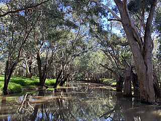
Mirrool Creek, a watercourse that is part of the Lachlan sub-catchment of the Murrumbidgee catchment in the Murray–Darling basin, is in the Riverina region of New South Wales, Australia. The course of the Mirrool Creek is indefinite at various locations.
Bakulari is a village located in Sohagara Panchayat of Guthani Block of Siwan district in the Indian state of Bihar.

Chümoukedima District is the 15th district of the Indian state of Nagaland. It was created on 18 December 2021. The district is bounded by Kohima District to the east, Peren District to the south, Tseminyü District & Niuland District to the north-east, Dimapur District to the north and Karbi Anglong District of Assam to the west and north-west. The district headquarter is located in the municipality of Chümoukedima.

