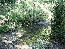
Kerthen Wood, or Kirthen Wood, is a hamlet near Townshend in Cornwall, England. [1] [2] It is in the civil parish of Crowan [3]
Kerthen Wood, or Kirthen Wood, is a hamlet near Townshend in Cornwall, England. [1] [2] It is in the civil parish of Crowan [3]

The Ordnance Survey National Grid reference system is a system of geographic grid references used in Great Britain, distinct from latitude and longitude.

The River Lynher flows through east Cornwall, England, and enters the River Tamar at the Hamoaze, which in turn flows into Plymouth Sound.

Cookbury is a village and civil parish in the local government district of Torridge, Devon, England. The parish, which lies about five miles east of the town of Holsworthy, is surrounded clockwise from the north by the parishes of Thornbury, Bradford, Ashwater, Hollacombe, and Holsworthy Hamlets. In 2001 its population was 158, little changed from the 146 residents it had in 1901.

Perranzabuloe is a coastal civil parish and a hamlet in Cornwall, England, United Kingdom. Perranzabuloe parish is bordered to the west by the Atlantic coast and St Agnes parish, to the north by Cubert parish, to the east by St Newlyn East and St Allen parishes and to the south by Kenwyn parish. The hamlet is situated just over a mile (2 km) south of the principal settlement of the parish, Perranporth; the hamlet is also seven miles (11 km) south-southwest of Newquay. Other settlements in the parish include Perrancoombe, Goonhavern, Mount and Callestick. The parish population was 5,382 in the 2001 census, increasing to 5,486 at the 2011 census.

Booby's Bay is a sandy beach near Padstow, Cornwall, England, UK. The beach is wide with many rock pools. It is completely covered by high tide and is popular with surfers, though may be dangerous for the amateur. There is a lifeguard on duty during the summer, but the water is often red-flagged. Access to the beach is by climbing down from the coast path, or walking along the beach at low tide. Dogs are allowed on the beach all year round. Booby's Bay has no beach at the highest tides, the ribs of a wrecked ship appear periodically as the sand is relocated by the sea and prevailing currents. During World War I the three masted sailing ship Carl of the German navy was beached and abandoned in Constantine Bay while being towed to London during a storm.
Hensbarrow Beacon is a hill in Cornwall, England, United Kingdom. It is situated a mile north-west of Stenalees village at grid reference SW 996 575. It is the highest natural point of the Hensbarrow uplands, a natural region and national character area.

Bodrean and Frogmore are farmstead settlements in Cornwall, England, United Kingdom, situated two miles north-northeast of Truro.

Carland Cross is a location in Cornwall, England, United Kingdom, about six miles north of Truro at OS grid reference OS grid ref SW846539. At Carland Cross there are a hamlet, a road junction and a large wind farm. The road junction is in the civil parish of St Erme, very close to the boundary with St Newlyn East.
Lantyan is a settlement in Cornwall, United Kingdom. It is situated on the west side of the River Fowey just over a mile (1.6 km) south of Lostwithiel.

The River Allen in north Cornwall is one of two rivers in Cornwall which share this name. In this case the name is the result of a mistake made in 1888 by Ordnance Survey, replacing the name Layne with Allen which is the old name for the lower reaches of the Camel. The other River Allen runs through Truro.

The De Lank River is a small river in north Cornwall, England. It is a tributary of the River Camel and is approximately nine miles (14.5 km) long from its source on Bodmin Moor to its confluence with the Camel two miles (3 km) south of St Breward.

Luckett is a hamlet in east Cornwall, England. It is situated in a former mining area beside the River Tamar approximately three miles (5 km) north of Callington. According to the Post Office the population at the 2011 census was included in the civil parish of Stokeclimsland

Clowance Wood is a hamlet in the civil parish of Crowan in west Cornwall, England. Clowance Wood is situated 1 mile (1.6 km) east of Leedstown and 4.7 miles (7.6 km) north-west of Helston.

Idless is a hamlet north of Truro in Cornwall, England. The River Allen rises north of St Allen and flows southwards through the Idless Valley into Truro. It is in the civil parish of Kenwyn.
Haye Farm is a farm in the parish of Callington, Cornwall, England.

Millook is a deep coastal valley and hamlet in the parish of Poundstock, on the north coast of Cornwall, England.

Mount Pleasant is a hamlet in the parish of Roche, Cornwall, England. The main A30 road used to pass through the hamlet but a dual carriageway bypass and graded junction have been constructed to the south of the original road. There is a Grade II listed eighteenth century guidestone beside the old road, consisting of a 5-foot (1.5 m) granite monolith with a rounded head. The text "WITHIEL" is carved into it, and the letters are painted.

Paramoor is a hamlet near St Mewan in Cornwall, England. Paramoor is southwest of Sticker and Paramoor Wood is nearby.
Loggans Moor is a nature reserve and Site of Special Scientific Interest, noted for its biological characteristics, in west Cornwall, England, UK. It is located 1 mile north-east of the town of Hayle, off the A30 road.
Kennack Sands is a beach and sand-dune system on the east coast of the Lizard Peninsula, Cornwall, England, UK.
| Unitary authorities | |
|---|---|
| Major settlements |
|
| Rivers | |
| Topics | |
Coordinates: 50°09′01″N5°23′03″W / 50.15032°N 5.3842644°W
| | This Cornwall location article is a stub. You can help Wikipedia by expanding it. |