Khodi खुदि | |
|---|---|
Rural municipality | |
 | |
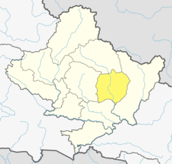
 Khodi Location in Nepal  Khodi Khodi (Nepal) | |
| Coordinates: 28°24′N84°19′E / 28.40°N 84.31°E | |
| Country | |
| Zone | Gandaki Zone |
| District | Lamjung District |
| Population (1991) | |
• Total | 3,212 |
| Time zone | UTC+5:45 (Nepal Time) |
| Postal Code | 33607 |
| Area code | 066 |
Khodi is a rural municipality in Lamjung District in the Gandaki Zone of northern-central Nepal. At the time of the 1991 Nepal census it had a population of 3212 people living in 664 individual households. [1]