Kielder Viaduct

Last updated

Kielder Viaduct
Kielder viaduct (1).jpg
Kielder skew viaduct, built to carry the Border Counties Railway over Deadwater Burn
Coordinates 55°13′29″N2°34′48″W / 55.2247°N 2.5799°W / 55.2247; -2.5799
OS grid reference NY632924
Carries
CrossesDeadwater Burn
Locale Northumberland
OwnerNorthumberland & Newcastle Society
Heritage status Scheduled monument [1] [2]
Characteristics
Design Skew arch viaduct
MaterialStone
Total length392 ft (119 m)
Longest spanSeven spans of 40 ft (12 m)
No. of spans7
Piers in water3
History
DesignerJohn Furness Tone
Construction start1858
Construction end1862
Opened1862 (1862)
Closed1 September 1958 (1958-09-01), as a railway
Location
Kielder Viaduct

Kielder Viaduct consists of seven semi-circular masonry skew arches and was built in 1862 by the North British Railway to carry the Border Counties Line across marshy land, which following flooding to create Kielder Water, became the place where Deadwater Burn joins Bakethin Reservoir. [3] Now closed to rail traffic, the bridge is currently used as a footpath.

History

Kielder Viaduct, spandrel detail Kielder viaduct (2).jpg
Kielder Viaduct, spandrel detail
Kielder Viaduct, information plaque Kielder viaduct (3).jpg
Kielder Viaduct, information plaque

The viaduct was conceived in a joint project of the Border Counties Railway and the North British Railway as part of the former's extension to Riccarton Junction in Scotland. The project was completed in 1862 but the Border Counties Railway had been absorbed by the North British Railway two years earlier. In order to meet with the approval of local landowner the Duke of Northumberland who had a shooting lodge nearby, the viaduct was built in a Baronial style and decorated with a battlemented parapet and faux arrow slits. [4] [5]

Robert Nicholson had been the engineer responsible for building the first section of the line but, on his death in 1855, his nephew John Furness Tone (1822–1881) [6] took on the task of completing the project and it was under his direction that contractors William Hutchinson and John Ridley built the viaduct. [4] The arches are constructed at a skewed angle and the stones are laid along helical courses, according to a set of principles attributed to architect and mathematician Peter Nicholson. [7] [8]

The railway company had hoped to tap the coal traffic from Plashetts colliery that opened nearby in the 1850s but this proved disappointing, although there was some traffic from forestry in the area. [5] Passenger traffic was always limited, though the line did open up the North Tyne valley and was in part responsible for the increase in population there. [5] The North British Railway, therefore, gained its own route between Edinburgh and Newcastle upon Tyne via Hexham but it compared poorly with the route via Berwick, taking almost five hours to complete the journey. [5]

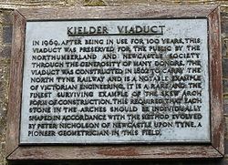
On 1 January 1923 ownership of the viaduct, along with the rest of the line, passed to the London and North Eastern Railway and thence to the North Eastern region of British Railways on nationalisation in 1948. The line through Kielder lost its passenger service on 15 October 1956 and closed completely on 1 September 1958 and the viaduct's future became uncertain when the £167 million Kielder reservoir project was begun in 1976, a substantial part of the route of the old line being lost under the waters. [5] However, steps were taken by the Northumberland and Newcastle Society [5] [9] to protect the viaduct itself by encasing the bases of its piers in concrete and waterproofing the bridge deck. [4] [5]

The structure is now a Scheduled Monument [1] [2] and forms part of a footpath from which walkers can enjoy the views from the top of its arches. [7]

Related Research Articles

<span class="mw-page-title-main">Royal Border Bridge</span> Bridge in Northumberland

The Royal Border Bridge spans the River Tweed between Berwick-upon-Tweed and Tweedmouth in Northumberland, England. It is a Grade I listed railway viaduct built between 1847 and 1850, when it was opened by Queen Victoria. It was designed by Robert Stephenson. It was built for the York, Newcastle and Berwick Railway and is still in regular use today, as part of the East Coast Main Line. Despite its name, the bridge does not in fact span the border between England and Scotland, which is approximately three miles further north.

<span class="mw-page-title-main">Barrasford</span> Village in Northumberland, England

Barrasford is a village in Northumberland, England. It is situated to the north of Hexham, on the North Tyne. Barrasford is an ancient village that lies within the shadow of Haughton Castle. The village is notable for being the location of a Bronze Age burial site where the Reaverhill Dagger was excavated in 1964. Today Barrasford is noted for its quarry.

Charlton is a village in Northumberland, England. It is about 1.5 miles (2.4 km) to the northwest of Bellingham, on the River North Tyne.

<span class="mw-page-title-main">Wark on Tyne</span> Human settlement in England

Wark on Tyne is a small village and civil parish in Northumberland, England, 12 miles (19 km) north of Hexham.

<span class="mw-page-title-main">Falstone</span> Human settlement in England

Falstone is a small village in Northumberland, England, just east of Kielder Water. The village is 8 miles (13 km) from the Anglo–Scottish border. The name Falstone means "speckled stone". Much of the village is clustered around its two churches, St. Peter's Anglican and the United Reformed Church.

The Blyth and Tyne Railway was a railway company in Northumberland, England, incorporated by Act of Parliament on 30 June 1852. It was created to unify the various private railways and waggonways built to carry coal from the Northumberland coalfield to Blyth and the River Tyne, which it took control of on 1st January 1853. Over time, the railway expanded its network to reach Morpeth (1857/8), North Seaton (1859), Tynemouth (1860/1), Newcastle upon Tyne (1864), and finally Newbiggin-by-the-Sea (1872). It became part of the much larger North Eastern Railway in 1874.

<span class="mw-page-title-main">Kielder</span> Human settlement in England

Kielder is a small, remote village in western Northumberland, England. Located at the head of Kielder Water and in the north west of Kielder Forest, the village is within three miles of the Scottish border.

<span class="mw-page-title-main">Wylam Railway Bridge</span> Bridge in Northumberland

Wylam Railway Bridge is a footbridge and former railway bridge crossing the River Tyne at Hagg Bank, approximately 12 mile (0.8 km) west of Wylam in Northumberland, England.

<span class="mw-page-title-main">Alston line</span> Partially operational railway line in Cumbria and Northumberland

The Alston Line was a 13-mile (21 km) single-track branch line, which linked Haltwhistle in Northumberland with Alston in Cumbria.

The Border Counties Railway was a railway line connecting Hexham in Northumberland, with Riccarton Junction on the Waverley Route in Roxburghshire.

John and Benjamin Green were a father and son who worked in partnership as architects in North East England during the early nineteenth century. John, the father was a civil engineer as well as an architect. Although they did carry out some commissions separately, they were given joint credit for many of their projects, and it is difficult to attribute much of their work to a single individual. In general, John Green worked on civil engineering projects, such as road and rail bridges, whereas Benjamin worked on projects that were more purely architectural. Their work was predominantly church and railway architecture, with a sprinkling of public buildings that includes their masterpiece, Newcastle's Theatre Royal.

<span class="mw-page-title-main">Skew arch</span>

A skew arch is a method of construction that enables an arch bridge to span an obstacle at some angle other than a right angle. This results in the faces of the arch not being perpendicular to its abutments and its plan view being a parallelogram, rather than the rectangle that is the plan view of a regular, or "square" arch.

<span class="mw-page-title-main">Deadwater, Northumberland</span> Human settlement in England

Deadwater is a small settlement in Northumberland, England, about 3 miles (5 km) north west of Kielder, Northumberland, on the English side of the border between Scotland and England. It is regarded as the source of the River North Tyne, which merges with the River South Tyne near Hexham, and continues around 93 miles/150 km to the North Sea.

<span class="mw-page-title-main">Tyne Valley line</span> Railway line in north of England

The Tyne Valley Line is a 58-mile (93 km) route, linking Newcastle upon Tyne with Hexham and Carlisle, England. The line follows the course of the River Tyne through Tyne and Wear and Northumberland. Five stations and two viaducts on the route are listed structures.

<span class="mw-page-title-main">Neidpath Viaduct</span> Bridge in Neidpath, Borders

Neidpath Viaduct, occasionally known as the Queen's Bridge, consists of eight stone skew arches and was built to carry the Symington to Peebles branch line of the Caledonian Railway over the River Tweed to the south-west of Neidpath Castle. Now closed to rail traffic the bridge is used as a footpath.

<span class="mw-page-title-main">Peter Nicholson (architect)</span> Scottish architect

Peter Nicholson was a Scottish architect, mathematician and engineer. Largely self-taught, he was apprenticed to a cabinet-maker but soon abandoned his trade in favour of teaching and writing. He practised as an architect but is best remembered for his theoretical work on the skew arch, his invention of draughtsman's instruments, including a centrolinead and a cyclograph, and his prolific writing on numerous practical subjects.

<span class="mw-page-title-main">York, Newcastle and Berwick Railway</span> Former English railway company

The York, Newcastle and Berwick Railway (YN&BR) was an English railway company formed in 1847 by the amalgamation of the York and Newcastle Railway and the Newcastle and Berwick Railway. Both companies were part of the group of business interests controlled by George Hudson, the so-called Railway King. In collaboration with the York and North Midland Railway and other lines he controlled, he planned that the YN&BR would form the major part of a continuous railway between London and Edinburgh. At this stage the London terminal was Euston Square and the route was through Normanton. This was the genesis of the East Coast Main Line, but much remained to be done before the present-day route was formed, and the London terminus was altered to King's Cross.

<span class="mw-page-title-main">Corby Bridge</span> Bridge in Cumbria, England

Corby Bridge is a railway viaduct adjacent to and immediately east of Wetheral railway station at Wetheral, near Carlisle, in north-western England, begun in 1830 and completed in 1834. It is 920 feet (280 m) long and 100 feet (30 m) high, and has been a Grade I listed building since 1 April 1957.

<span class="mw-page-title-main">Lambley Viaduct</span> Bridge in Northumberland

Lambley Viaduct is a stone bridge across the River South Tyne at Lambley in Northumberland. Formerly a railway bridge, it remains open to pedestrians but one end of the viaduct has been fenced off.

<span class="mw-page-title-main">Gelt Bridge</span> Bridge in Carlisle, England

The Gelt Bridge or Gelt Viaduct is a skew arch railway viaduct in the parish of Hayton, east of Carlisle in Cumbria, north west England. Built from 1832, it is one of the earliest and largest skew bridges in Britain. It is a Grade II* listed building.

References

  1. 1 2 Historic England. "Kielder Viaduct (1002913)". National Heritage List for England . Retrieved 8 September 2018.
  2. 1 2 Historic England. "Kielder Viaduct (14588)". Research records (formerly PastScape). Retrieved 8 September 2018.
  3. Peter McDermott. "NY6392 : Kielder Viaduct". Geograph . Retrieved 24 August 2009.
  4. 1 2 3 Rennison, Robert W. (1996). Civil Engineering Heritage: Northern England (2nd ed.). Thomas Telford. p. 28. ISBN   0-7277-2518-1.
  5. 1 2 3 4 5 6 7 "North Tyne – Kielder Railway Viaduct". Bridges On The Tyne. Retrieved 24 August 2009.
  6. "Obituary. John Furness Tone, 1822–1881". Institution of Civil Engineers . Retrieved 24 August 2009.
  7. 1 2 "Kielder Viaduct". Forgotten Relics of an Enterprising Age. Retrieved 24 August 2009.
  8. Nicholson, Peter (1828). A Popular and Practical Treatise on Masonry and Stone-cutting (1st ed.). London: Thomas Hurst, Edward Chance & Co. pp.  39–60.
  9. "The Northumberland and Newcastle Society Home page". Northumberland & Newcastle Society. Archived from the original on 29 September 2011. Retrieved 1 February 2011.
Next crossing upstreamRiver North TyneNext crossing downstream
Butteryhaugh BridgeKielder Viaduct Falstone Bridge