Causey Arch

Last updated

Causey Arch
Causey Arch.jpg
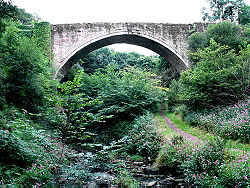
North side of the bridge
Coordinates 54°53′51″N1°41′16″W / 54.8974°N 1.6878°W / 54.8974; -1.6878
OS grid reference NZ 20126 55896
CarriesWaggonway (disused); footpath
CrossesCausey Burn
Locale Stanley, County Durham
Characteristics
DesignArch
MaterialStone
Total length105 ft (32 m)
Height80 ft (24 m)
No. of spans1
History
DesignerRalph Wood
Opened1727 (1727)
Statistics
Listed Building – Grade I
Official nameCAUSEY ARCH
Designated19 July 1950 (1950-07-19)
Reference no.1240816 [1]
Location
Causey Arch

The Causey Arch is a bridge near Stanley in County Durham, northern England. It is the oldest surviving single-arch railway bridge in the world, and a key element of the industrial heritage of England. It carried an early wagonway (horse-drawn carts on wooden rails) to transport coal. The line was later diverted, and no longer uses the bridge. [2]

Contents

History

It was built in 1725–26 by stonemason Ralph Wood, funded by a conglomeration of coal-owners known as the "Grand Allies" (founded by Colonel Liddell, the Hon. Charles Montague and George Bowes the owner of Gibside Estate on which the bridge is situated) at a cost of £12,000. Two tracks crossed the Arch: one (the "main way") to take coal to the River Tyne, and the other (the "bye way") for returning the empty wagons. Over 900 horse-drawn wagons crossed the arch each day using the Tanfield Railway.

When the bridge was completed in 1726, it was the longest single-span bridge in the country with an arch span of 31 metres (102 ft), a record it held for thirty years until 1756 when the Old Bridge was built in Pontypridd, Wales. After he designed the bridge, Ralph Wood was so afraid that his arch would collapse that he committed suicide in 1727, [3] but the bridge still stands today. An inscription on a sundial at the site reads "Ra. Wood, mason, 1727".

Use of the arch declined when Tanfield Colliery was destroyed by fire in 1739.

Present status

The Arch has been Grade I listed since 1950. [4] It was restored and reinforced in the 1980s. There are a series of scenic public paths around the area and the Causey Burn which runs underneath it. The quarry near the bridge is a popular spot for local rock climbers.

Causey Burn itself flows into Beamish Burn which then flows into the River Team eventually discharging into the River Tyne.

See also

Related Research Articles

<span class="mw-page-title-main">Tanfield, County Durham</span> Human settlement in England

Tanfield is a former mining village in County Durham, England, near Stanley, and the location of Tanfield Railway, the Causey Arch and Tanfield School.

<span class="mw-page-title-main">Wagonway</span> Railway using horses to pull goods wagons

Wagonways, also known as horse-drawn railways and horse-drawn railroad consisted of the horses, equipment and tracks used for hauling wagons, which preceded steam-powered railways. The terms plateway, tramway, dramway, were used. The advantage of wagonways was that far bigger loads could be transported with the same power.

<span class="mw-page-title-main">Tanfield Railway</span> Preserved railway in County Durham, England

The Tanfield Railway is a 4 ft 8+12 instandard gauge heritage railway in Gateshead and County Durham, England. Running on part of a former horse-drawn colliery wooden waggonway, later rope & horse, lastly rope & loco railway. It operates preserved industrial steam locomotives. The railway operates a passenger service every Sunday, plus other days, as well as occasional demonstration coal, goods and mixed trains. The line runs 3 miles (4.8 km) between a southern terminus at East Tanfield, Durham, to a northern terminus at Sunniside, Gateshead. Another station, Andrews House, is situated near the Marley Hill engine shed. A halt also serves the historic site of the Causey Arch. The railway claims it is "the world's oldest railway" because it runs on a section dating from 1725, other parts being in use since 1621.

<span class="mw-page-title-main">North Tyneside Steam Railway</span> Visitor attraction in North East England

The North Tyneside Steam Railway and Stephenson Steam Railway are visitor attractions in North Shields, North East England. The museum and railway workshops share a building on Middle Engine Lane adjacent to the Silverlink Retail Park. The railway is a standard gauge line, running south for 2 miles (3.2 km) from the museum to Percy Main. The railway is operated by the North Tyneside Steam Railway Association (NTSRA). The museum is managed by Tyne and Wear Archives and Museums on behalf of North Tyneside Council.

Burnopfield is a village in County Durham, in England. It is situated north of Stanley and Annfield Plain, close to the River Derwent and is 564 feet above sea level. There are around 4,553 inhabitants in Burnopfield. It is located 7 miles from Newcastle upon Tyne and 15 miles from Durham.

<span class="mw-page-title-main">Causey, County Durham</span> Human settlement in England

Causey is a village in County Durham, in England. It is situated a short distance to the north of Stanley.

<span class="mw-page-title-main">Shildon</span> Town and civil parish in County Durham, England

Shildon is a town and civil parish in County Durham, in England. The population taken at the 2011 Census was 9,976. The town has the Locomotion Museum, due to it having the first station, built in 1825, and locomotive works on the Stockton and Darlington Railway.

<span class="mw-page-title-main">Wylam</span> Human settlement in England

Wylam is a village and civil parish in the county of Northumberland. It is located about 10 miles (16 km) west of Newcastle upon Tyne.

Wideopen, also occasionally spelled Wide Open, is a village in the North Tyneside metropolitan borough of Tyne and Wear, England, around 5 miles (8.0 km) north of Newcastle.

<span class="mw-page-title-main">Leamside line</span> Former railway line in North East England

The Leamside Line, originally part of the Durham Junction Railway, is a disused railway line, located in the North East of England. The alignment diverges from the East Coast Main Line at Tursdale Junction, travelling a distance of 21 miles north through the Durham Coalfield and Washington, prior to joining the Durham Coast Line at Pelaw Junction. The Leamside Line closed to passenger traffic in 1964, under the Beeching cuts.

<span class="mw-page-title-main">Seaton Sluice</span> Human settlement in England

Seaton Sluice is a village in Northumberland. It lies on the coast at the mouth of the Seaton Burn, midway between Whitley Bay and Blyth. It has a population of about 3,000 people.

<span class="mw-page-title-main">Lobley Hill</span>

The Stanhope and Tyne Railway was an early British mineral railway, that ran from Stanhope in County Durham, to South Shields at the mouth of the River Tyne. The object was to convey limestone from Stanhope and coal from West Consett and elsewhere to the Tyne, and to local consumers. Passengers were later carried on parts of the line.

<span class="mw-page-title-main">York, Newcastle and Berwick Railway</span> Former English railway company

The York, Newcastle and Berwick Railway (YN&BR) was an English railway company formed in 1847 by the amalgamation of the York and Newcastle Railway and the Newcastle and Berwick Railway. Both companies were part of the group of business interests controlled by George Hudson, the so-called Railway King. In collaboration with the York and North Midland Railway and other lines he controlled, he planned that the YN&BR would form the major part of a continuous railway between London and Edinburgh. At this stage the London terminal was Euston Square and the route was through Normanton. This was the genesis of the East Coast Main Line, but much remained to be done before the present-day route was formed, and the London terminus was altered to King's Cross.

<span class="mw-page-title-main">Marley Hill</span>

Marley Hill is a former colliery village about six miles to the south west of Gateshead, near the border between Tyne and Wear and County Durham. It has been part of the Metropolitan Borough of Gateshead since 1974. Prior to this it was part of Whickham Urban District. It lies within the Whickham South & Sunniside electoral ward of the Blaydon parliamentary constituency.

<span class="mw-page-title-main">Brandling Junction Railway</span> Former railway in England

The Brandling Junction Railway was an early railway in County Durham, England. It took over the Tanfield Waggonway of 1725 that was built to bring coal from Tanfield to staiths on the River Tyne at Dunston. The Brandling Junction Railway itself opened in stages from 1839, running from Gateshead to Wearmouth and South Shields. Wearmouth was regarded at the time as the "Sunderland" terminal.

<span class="mw-page-title-main">Newcastle & Carlisle Railway</span>

The Newcastle & Carlisle Railway (N&CR) was an English railway company formed in 1825 that built a line from Newcastle upon Tyne on Britain's east coast, to Carlisle, on the west coast. The railway began operating mineral trains in 1834 between Blaydon and Hexham, and passengers were carried for the first time the following year. The rest of the line opened in stages, completing a through route between Carlisle and Gateshead, south of the River Tyne in 1837. The directors repeatedly changed their intentions for the route at the eastern end of the line, but finally a line was opened from Scotswood to a Newcastle terminal in 1839. That line was extended twice, reaching the new Newcastle Central Station in 1851.

<span class="mw-page-title-main">Fawdon Wagonway</span>

The Fawdon Wagonway was from 1818 to 1826 a 1 mile 3 furlongs (2.2 km) long horse-drawn and partially rope-operated industrial railway in Fawdon near Newcastle upon Tyne. It was the first cable car employing a moving rope that could be picked up or released by a grip on the cars.

<span class="mw-page-title-main">Seaton Burn Wagonway</span> Cable railway near Newcastle upon Tyne, England

The Seaton Burn Wagonway was from 1826 to 1920 a partially horse-drawn and partially rope-operated industrial railway with a gauge of 4 ft 6 in near Newcastle upon Tyne.

References

  1. Historic England & 1240816.
  2. "Sunniside Local History Society". www.sunnisidelocalhistorysociety.co.uk. Retrieved 12 August 2021.
  3. "Causey Arch Stanley, England". Atlas Obscura. Retrieved 24 April 2021.
  4. Historic England (19 July 1950). "Causey Arch (Grade I) (1240816)". National Heritage List for England . Retrieved 14 August 2021.