
Waterford is a city in County Waterford in the south-east of Ireland. It is located within the province of Munster. The city is situated at the head of Waterford Harbour. It is the oldest and the fifth most populous city in the Republic of Ireland. It is the ninth most populous settlement on the island of Ireland. According to the 2022 census, 60,079 people live in the city, with a wider metropolitan population of 82,963.

Cahir is a town in County Tipperary in Ireland. It is also a civil parish in the barony of Iffa and Offa West.
Dungarvan is a coastal town and harbour in County Waterford, on the south-east coast of Ireland. Prior to the merger of Waterford County Council with Waterford City Council in 2014, Dungarvan was the county town and administrative centre of County Waterford. Waterford City and County Council retains administrative offices in the town. The town's Irish name means "Garbhann's fort", referring to Saint Garbhann who founded a church there in the seventh century.

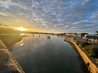
Ardmore is a seaside resort and fishing village in County Waterford, Ireland, not far from Youghal on the south coast of Ireland. It has a permanent population of around 430, that increases in the tourist season. It is believed to be the oldest Christian settlement in Ireland. According to tradition, Saint Declan lived in the region in the early 5th century, and Christianised the area before the coming of Saint Patrick.
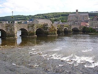
Carrick-on-Suir is a town in County Tipperary, Ireland. It lies on both banks of the River Suir. The part on the north bank of the Suir lies in the civil parish of "Carrick", in the historical barony of Iffa and Offa East. The part on the south bank lies in the civil parish of Kilmolerin in the barony of Upperthird, County Waterford.
Newbridge, officially known by its Irish name Droichead Nua, is a town in County Kildare, Ireland. While the nearby Great Connell Priory was founded in the 13th century, the town itself formed from the 18th century onwards, and grew rapidly alongside a military barracks which opened in the early 19th century. Taking on the name Newbridge in the 20th century, the town expanded to support the local catchment, and also as a commuter town for Dublin. Doubling in population during the 20 years between 1991 and 2011, its population of 22,742 in 2016 makes it the largest town in Kildare and the fifteenth-largest in Ireland.
Thomastown, historically known as Grennan, is a town in County Kilkenny in the province of Leinster in the south-east of Ireland. It is a market town along a stretch of the River Nore which is known for its salmon and trout, with a number of historical landmarks in the vicinity. Visitor attractions include Jerpoint Abbey, Kilfane Glen gardens, and Mount Juliet Golf Course.

Mountshannon is a village in east County Clare, Ireland. It is part of the Catholic parish Mountshannon-Whitegate. The village is on the western shore of Lough Derg, north of Killaloe. Mountshannon won the Irish Tidy Towns Competition in 1981.

Riverstown, historically called Ballyederdaowen, is a village in County Sligo, Ireland. Known for its musical tradition it is located at a bridging point of the River Unshin (Arrow), 17.2 km south of Sligo town and 4 km east of the N4 road.

Kilmacthomas or Kilmactomas, often referred to locally as "Kilmac", is a town on the River Mahon in County Waterford, Ireland. It lies on the R677, a road north of the N25 national primary road from Dungarvan to Waterford.

Bunmahon, also called Bonmahon, is a coastal village in County Waterford, Ireland, at the mouth of the River Mahon. During the 19th century, when copper mines operated in the area, Bonmahon was a mining village. As of the 21st century, the village and its beach lie on a tourist route.

Kilcullen, formally Kilcullen Bridge, is a small town on the River Liffey in County Kildare, Ireland. Its population of 3,473 at the 2011 census made it the 12th largest settlement in County Kildare and the fastest growing in the county, having doubled in population from 1,483 in the census of 2002. By 2016, the population had risen to 3,710. It is situated primarily in the Barony of Kilcullen, with a part in the Barony of Naas South, and subsidiary areas include Logstown, Harristown, Carnalway and Brannockstown, Gilltown, Nicholastown, and Castlemartin.

Mooncoin is an urban area in County Kilkenny, in Ireland. The population was 1,175 in 2016. Historically part of the Gaelic kingdom of Osraige, today it is in the far south of the county of Kilkenny, located in the valley of the River Suir. It is surrounded by the uplands of the Slievenamon and Comeragh Mountains, just 10 kilometres (6.2 mi) north of Waterford City along the N24 national primary road, and it is 48 kilometres (30 mi) south of Kilkenny.

Tallow is a town, civil parish and townland in County Waterford, Ireland. Tallow is in the province of Munster near the border between County Cork and County Waterford and situated on a small hill just south of the River Bride.
Knockanore is a rural village and townland in County Waterford, situated approximately 9 miles (15 km) from neighbouring towns Youghal and Tallow .The village is located on a designated scenic routeway.
Aglish is a village in west County Waterford, Ireland.
Clashmore is a village, townland and civil parish in west County Waterford, Ireland. The village and surrounding district are very low-lying, as the name Clais Mhór implies; elsewhere the land is rather hilly. It is also a parish in the Roman Catholic Diocese of Waterford and Lismore.

Grange is a small village and townland in west County Waterford, Ireland. It borders Ardmore and An Seanphobal. Ardmore and Grange are two villages that make up the Ardmore-Grange parish.

Ballycullane is a small village located in the south-west of County Wexford, in Ireland. As of the 2016 census, it had a population of 318 people.
Ballinroad is a village approximately 3 km from Dungarvan, County Waterford on the south coast of Ireland. Ballinroad grew rapidly during the Celtic tiger era and is now one of Dungarvan's main dormitory areas.


