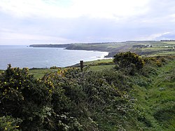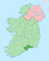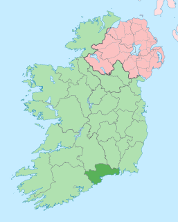
County Waterford is a county in Ireland. It is in the province of Munster and is part of the South-East Region. It is named after the city of Waterford. Waterford City and County Council is the local authority for the county. The population of the county at large, including the city, was 116,176 according to the 2016 census. The county is based on the historic Gaelic territory of the Déise. There is an Irish-speaking area, Gaeltacht na nDéise, in the south-west of the county.
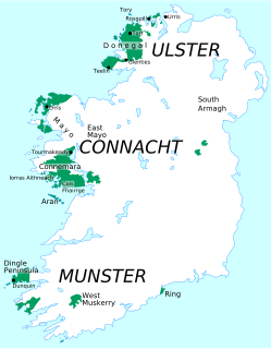
Gaeltacht includes individually to any, or collectively to all, of the districts where the Irish government recognises that the Irish language is the predominant vernacular, or language of the home. The Gaeltacht districts were first officially recognised during the 1920s in the early years of the Irish Free State, following the Gaelic Revival, as part of a government policy aimed at restoring the Irish language.

Dungarvan is a coastal town and harbour in County Waterford, on the south-east coast of Ireland. Prior to the merger of Waterford County Council with Waterford City Council in 2014, Dungarvan was the county town and administrative centre of County Waterford. Waterford City and County Council retains administrative offices in the town. The town's Irish name means "Garbhann's fort", referring to Saint Garbhann who founded a church there in the seventh century. The town lies on the N25 road, which connects Cork, Waterford and Rosslare Europort.

Ballyferriter is a Gaeltacht village in County Kerry, Ireland. It is in the west of the Corca Dhuibhne (Dingle) peninsula and according to the 2002 census, about 75% of the town's population speak the Irish language on a daily basis. The village is named after the Norman-Irish Feiritéar family who settled in Ard na Caithne in the late medieval period. The last Chief of the Name was the seventeenth-century Bard and leader Piaras Feiritéar who was executed. The older Irish name for the village An B[h]uailtín is still used locally.
Baile na hAbhann, anglicised as Ballynahown, is a Gaeltacht village and townland about 31 km west of Galway, Ireland, on the R336 regional road between Indreabhán and Casla. The name means "river settlement".

Munster Irish is the dialect of the Irish language spoken in the province of Munster. Gaeltacht regions in Munster are found in the Gaeltachtaí of the Dingle Peninsula in west County Kerry, in the Iveragh Peninsula in south Kerry, in Cape Clear Island off the coast of west County Cork, in Muskerry West; Cúil Aodha, Ballingeary, Ballyvourney, Kilnamartyra, and Renaree of central County Cork; and in an Rinn and an Sean Phobal in Gaeltacht na nDéise in west County Waterford.

Ring or Ringagonagh is a parish within the Irish-speaking Gaeltacht na nDéise area in County Waterford, Ireland. It lies on a peninsula about eleven kilometres (7 mi) south of Dungarvan. The main settlement is the village of Ring or Ringville, which is within the townland of Ballynagaul.

Ahiohill is a small village in County Cork, Ireland. The historical spelling for the area, Aghyohil, is reflected in the names of two local townlands, Aghyohil Beg and Aghyohil More. The village lies between the towns of Bandon, Clonakilty and Ballineen/Enniskean. Ahiohill has one pub, "The Four Winds", and is home to Oliver Plunkett's GAA.

Ranafast or Rinnafarset, officially only known by its Irish name Rann na Feirste is a Gaeltacht village and townland in the Rosses region of northwest County Donegal, Ireland.

Ballynanty, or Ballynantybeg, is a neighbourhood and electoral district on the north side of Limerick in the mid-west of Ireland.
Ballinroad is a village approximately 3 km from Dungarvan, County Waterford on the south coast of Ireland. Ballinroad grew rapidly during the Celtic tiger era and is now one of Dungarvan's main dormitory areas.

Old Parish is a village in west County Waterford, Ireland. It is part of the Gaeltacht in Waterford Gaeltacht na nDéise.
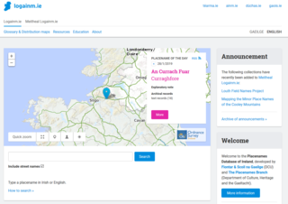
The Placenames Database of Ireland, also known as logainm.ie, is a database and archive of place names in Ireland. It was created by Fiontar, Dublin City University in collaboration with the Placenames Branch of the Department of Tourism, Culture, Arts, Gaeltacht, Sport and Media.

Gaeltacht na nDéise is a Gaeltacht area in County Waterford consisting of the areas of Ring and Old Parish. It is located 10 km from the town of Dungarvan. Gaeltacht na nDéise has a population of 1,816 people and encompasses a geographical area of 62 km2. This represents 1% of total Gaeltacht area.
Séamus Ó hEocha nicknamed "An Fear Mór", was an Irish educator and briefly an independent senator. He was active in the Gaelic League and became head teacher of Coláiste na Rinne in County Waterford.
Smallcounty or ‘’’Small County’’’ is a historical barony in County Limerick, Ireland. Settlements in the barony include Hospital, Herbertstown, Fedamore, Knockainy, and Six-Mile-Bridge.
Kilbeacon is a civil parish in the ancient barony of Knocktopher. It is located in the south of County Kilkenny, Ireland and is around 22 miles (35 km) south of the city of Kilkenny on the road to Waterford. The parish contains 3,151 statute acres. According to Lewis's survey of 1837, "At Earlsrath was a large fort, encompassed by a fosse and a bank about 20 feet high.". In 1833, there were 383 inhabited houses in the parish; of these, 270 families were primarily engaged in agriculture, 61 in manufactures or crafts, 52 in other. The total population was 2284 people.

Decies-within-Drum is a barony in County Waterford, Republic of Ireland.
Kilcommon, is a civil parish in the ancient barony of Ballinacor South in County Wicklow, Ireland. The parish is centered on the village of Tinahely. It is divided into 28 townlands
Ballinard is a civil parish and townland located in the eastern part of County Limerick, Ireland. The civil parish is part of the barony of Smallcounty. The largest population centre is the village of Herbertstown. The south-eastern part of the parish borders the parish of Kilcullane. Geologically, the parish rests on a substratum of limestone, except in some few places where the basalt rises.
