
The Hill of Tara is a hill and ancient ceremonial and burial site near Skryne in County Meath, Ireland. Tradition identifies the hill as the inauguration place and seat of the High Kings of Ireland; it also appears in Irish mythology. Tara consists of numerous monuments and earthworks—dating from the Neolithic to the Iron Age—including a passage tomb, burial mounds, round enclosures, a standing stone, and a ceremonial avenue. There is also a church and graveyard on the hill. Tara forms part of a larger ancient landscape and Tara itself is a protected national monument under the care of the Office of Public Works, an agency of the Irish Government.
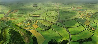
Rathcroghan is a complex of archaeological sites near Tulsk in County Roscommon, Ireland. It is identified as the site of Cruachan, the traditional capital of the Connachta, the prehistoric and early historic rulers of the western territory. The Rathcroghan Complex is a unique archaeological landscape with many references found in early Irish medieval manuscripts.

John Palliser was an Irish-born geographer and explorer. Following his service in the Waterford Militia and hunting excursions to the North American prairies, he led the British North American Exploring Expedition which investigated the geography, climate and ecology of what would later become western Canada.

Souterrain is a name given by archaeologists to a type of underground structure associated mainly with the European Atlantic Iron Age.
Union Hall, also Unionhall, is a small fishing village located in County Cork, Ireland, located on the west side of Glandore Harbour. Its nearest neighbour to the west is Castletownshend; to the east, Glandore village. It is approximately 10 kilometres south-east of Skibbereen. As of the 2016 census, 270 people were living in Union Hall.

Ballybough is an inner city district of northeast Dublin city, Ireland. Adjacent areas include the North Strand and Clonliffe.

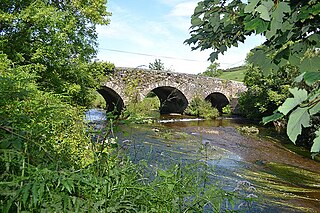
Bennettsbridge is a village in County Kilkenny in Ireland. It is situated on the River Nore 6 kilometres (3.7 mi) south of Kilkenny city, in the centre of the county. Bennettsbridge is a census town, and had population of 745 as of the 2016 census.

Island Bridge, formerly Sarah or Sarah's Bridge, is a road bridge spanning the River Liffey, in Dublin, Ireland which joins the South Circular Road to Conyngham Road at the Phoenix Park.

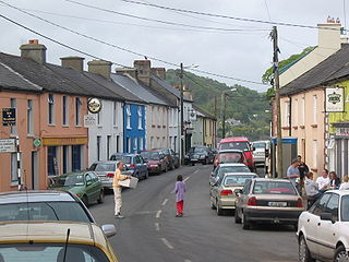
Kilmacthomas or Kilmactomas, often referred to locally as "Kilmac", is a town on the River Mahon in County Waterford, Ireland. It lies on the R677, a road north of the N25 national primary road from Dungarvan to Waterford.

River Mahon flows from the Comeragh Mountains in County Waterford, Ireland.

Lemybrien is a small village and townland in County Waterford, Ireland. It is on the N25 Cork to Waterford City road. Lemybrien is in the foothills of the Comeragh Mountains, in an area of County Waterford known as "The Déise". As of the 2016 census, the village had a population of 192 people, of whom 104 were male and 88 female.

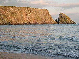
Bunmahon, also called Bonmahon, is a coastal village in County Waterford, Ireland, at the mouth of the River Mahon. During the 19th century, when copper mines operated in the area, Bonmahon was a mining village. As of the 21st century, the village and its beach lie on a tourist route.
Ballylaneen is a small village and townland in County Waterford, Ireland, approximately halfway between the villages of Kilmacthomas and Bunmahon on a hill by the River Mahon. Ballylaneen is in a civil parish of the same name.

The Comeragh Mountains are a glaciated mountain range situated in southeast Ireland in County Waterford. They are located between the town of Dungarvan and stretch inland to the town of Clonmel on the County Tipperary border and the villages of Kilrossanty and Kilmacthomas in County Waterford.

Kilrossanty GAA is a Gaelic Athletic Association (GAA) club located in Lemybrien, County Waterford, Ireland. The club is named for the nearby village of Kilrossanty. It plays home games at Pairc Naomh Brid. Kilrossanty is one of the oldest GAA clubs in Waterford and one of the larger Gaelic Football clubs there.

Clondrohid is a village and civil parish in County Cork, Ireland, four miles (6 km) north of Macroom. As of the 2022 census, the population of the village was recorded as 180, down slightly from 188 people as of the 2011 census.
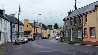
Drimoleague is a village on the R586 road at its junction with the R593 in County Cork, Ireland. It lies roughly halfway between the towns of Dunmanway and Bantry, within the civil parish of Dromdaleague. As of the 2022 census of Ireland, Drimoleague had 486 residents.

Kilrossanty is a small village and civil parish in County Waterford, Ireland. It lies between the Comeragh Mountains and the R676 road between Dungarvan and Carrick-on-Suir, close to the Mahon Falls. It is 11 km (7 mi) north of Dungarvan, and 32 km (20 mi) west of Waterford city. Kilrossanty is in a townland of the same name.
Decies-without-Drum is a barony in County Waterford, Ireland.

