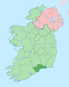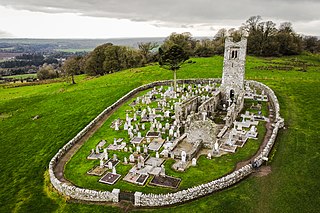
Slane is a village in County Meath, in Ireland. The village stands on a steep hillside on the left bank of the River Boyne at the intersection of the N2 and the N51. As of the 2022 census, Slane's population was 1,445. The village and surrounding area contains many historic sites dating back over 5,000 years. The village centre, as it is laid-out today, dates mainly from the 18th century. The village is in a townland and civil parish of the same name.

Cahir is a town in County Tipperary in Ireland. It is also a civil parish in the barony of Iffa and Offa West.

Tramore is a seaside town in County Waterford, on the southeast coast of Ireland. It has a population of 11,277 as per the 2022 census, the second largest town in the county.
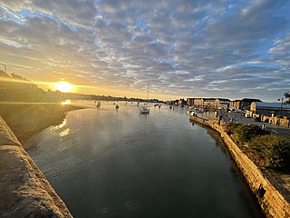
Dungarvan is a coastal town and harbour in County Waterford, on the south-east coast of Ireland. Prior to the merger of Waterford County Council with Waterford City Council in 2014, Dungarvan was the county town and administrative centre of County Waterford. Waterford City and County Council retains administrative offices in the town. The town is in a townland and civil parish of the same name.

Midleton is a town in south-eastern County Cork, Ireland. It lies approximately 16 km east of Cork City on the Owenacurra River and the N25 road, which connects Cork to the port of Rosslare. A satellite town of Cork City, Midleton is part of Metropolitan Cork. It is the central hub of business for the East Cork Area. Midleton is within the Cork East Dáil constituency.

Ardmore is a seaside resort and fishing village in County Waterford, Ireland, not far from Youghal on the south coast of Ireland. The village is in a civil parish of the same name. As of the 2022 census, the village had a population of 468. Ardmore is believed to be the oldest Christian settlement in Ireland. According to tradition, Saint Declan lived in the region in the early 5th century, and Christianised the area before the coming of Saint Patrick.

Bagenalstown, officially named Muine Bheag, is a small town on the River Barrow in County Carlow, Ireland.

Thomastown, historically known as Grennan, is a town in County Kilkenny in the province of Leinster in the south-east of Ireland. It is a market town along a stretch of the River Nore which is known for its salmon and trout, with a number of historical landmarks in the vicinity. Visitor attractions include Jerpoint Abbey, Kilfane Glen gardens, and Mount Juliet Golf Course. The town is in a civil parish of the same name. As of the 2022 census, Thomastown had a population of 2,305, making the town the third most populous in the county.
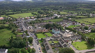
Cappamore is a small town in northeast County Limerick in the midwest of Ireland. It is also a parish in the Roman Catholic Archdiocese of Cashel and Emly.

Bennettsbridge is a village in County Kilkenny in Ireland. It is situated on the River Nore 6 kilometres (3.7 mi) south of Kilkenny city, in the centre of the county. Bennettsbridge is a census town, and had population of 745 as of the 2016 census.

Ballyhale is a village in the south east of Ireland. Located in the south of County Kilkenny, south of the city of Kilkenny and roughly halfway to Waterford city.

Mullinavat is a town in south County Kilkenny, Ireland. Its main industries are tourism and agriculture. The town's name in Irish translates as 'mill of the stick' which, according to local tradition, may refer to a mill which could only be approached by means of a rough stick over the Glendonnel River, close to where Mullinavat Bridge is now located.

Portlaw is a town in County Waterford, Ireland. It is also a parish in the Roman Catholic Diocese of Waterford and Lismore. It is situated approximately 14 km west-north-west of Waterford City, where the Clodiagh meets the Suir.

Tallow is a town, civil parish and townland in County Waterford, Ireland. Tallow is in the province of Munster near the border between County Cork and County Waterford and situated on a small hill just south of the River Bride.

Kilsheelan is a village and civil parish within the barony of Iffa and Offa East in County Tipperary, Ireland. A part of the civil parish is in neighbouring County Waterford. It is also one half of the Roman Catholic parish of Kilsheelan & Kilcash in the Roman Catholic Diocese of Waterford and Lismore.
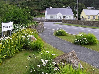
Croithlí or Croichshlí is a village in the Gaeltacht parishes and traditional districts of Gweedore and The Rosses in the west of County Donegal in Ulster, the northern province in Ireland. The two 'districts' are separated by the Crolly River. It has one convenience shop/restaurant and petrol station and one public house, Páidí Óg's. Crolly is located in two baronies: the Gweedore part of the village is in the Barony of Kilmacrenan, while The Rosses part of the village is in the Barony of Boylagh, the Crolly River being the boundary between the two baronies.

Ballyhack is a small village located in the south-west of County Wexford, in Ireland, on the eastern shore of the Waterford Harbour, which is the estuary of The Three Sisters

Kilmeadan or Kilmeaden is a village in County Waterford, Ireland. It is 10 km (6 mi) west of the centre of Waterford city on the R680 road. The village is in a civil parish of the same name. Kilmeaden townland is nearby the village, at Old Kilmeaden.
Mahon Bridge, also spelled Mahonbridge, is a village in the parish of Kilrossanty in mid County Waterford, Ireland. It is on the R676 road between Carrick on Suir and Dungarvan, and the nearest town is Kilmacthomas.


